Detailed description of the research and research plan.
Relevance to the call
This project addresses sea ice loss (=de-icing) on biodiversity and ecosystem services in Arctic coastal ecosystems across spatial scales of relevance to multiple types of decisions. We are aiming to determine potential early warning of (socio-) ecological breakpoints and regime shifts and provide scientific and social science advices for sustainable ecosystem based management of coastal regions in the high-Arctic.Rationale
The Arctic is characterised by extensive coasts that constitute 34% of the total global coastline. Nearshore waters are among the most productive regions in the Arctic and the coastal zone has always been the preferred ecotype for humans in the area. Here, a strong coupling between sea and land exists, and shallow bottom depths create tight ice-pelagic-benthic coupling. These highly productive regions are also critical breeding and foraging grounds for many fish, bird and marine mammal species, which combined provide a valuable host of ecosystem services that are vulnerable to climate induced stressors. Melting of permafrost, shrinking of ice pack and retreat of glaciers are already subjects of intensive research, while the reduction of landfast ice and ice foot (seasonal coastal ice) has received much less attention. Coastal de-icing will impact the Arctic coastline. Physically it will lead to more wave action, and erosion, and earlier snow melt and increased river runoff will have implications for nutrients and the underwater light regime and, thus, for primary production and primary consumers. The Arctic supra-littoral region has been regarded as barren due to ice scouring. De-icing and continued warming will facilitate colonization of the intertidal zone by Arctic and boreal flora and fauna. Disappearance of coastal sea ice may, however, also result in habitat loss. Recent studies show that the coastal sea ice may serve as an important nursery ground for benthic and pelagic offspring with several thousands of individuals per square meter of sea ice in spring when ice algae grow (Bluhm et al 2018).Sea ice based primary production is also essential for Arctic top predators (Brown et al 2018). Increased coastal erosion and sediment loads will physically change the nearshore bottom habitats and, thus, the biodiversity of these regions with cascading effects on food webs. Consequently, the coastal ecosystem goods and services (provisional, regulatory, socio-cultural) will also encounter changes. Extensive loss of Arctic sea ice opens up new routes for commercial ships. Increases in global trade, urbanization and travel create new opportunities for organisms to move across previously isolated regions advancing biotic homogenization and extinctions (Miller & Ruiz 2014). At present the extent of protected coastal marine ecosystems in the Arctic remains very small in comparison with the terrestrial environment (CAFF 2013), despite that Arctic coastal environments are recognised as some of the most threatened ecosystems on Earth (Lantuit et al 2011). This fact led to the recent establishment of the Coastal Expert Monitoring Group (CEMG), which is part of the Circumpolar Biodiversity Monitoring Program (CBMP, www.cbmp.is) under the Arctic Council’s Conservation of Arctic Flora and Fauna (CAFF, www.caff.is) working group. Arctic coastal biodiversity is under growing pressure as climate change and human activities increase, necessitating that government managers, industries, conservation organisations and communities have access to timely and complete biodiversity status and trend data.Hypotheses, approaches and choice of methods
Our overarching hypothesis of the ACCES project is that de-icing of Arctic coasts will have multidimensional consequences for ecosystem biodiversity and function - leading to socio- ecological breakpoints and regime shifts in near future. Through multiple (and often interrelated) abiotic, biotic and human induced stressors “native” species assemblages and distribution patterns will change and alter coastal marine food web structures and livelihoods of coastal communities.The central objectives of the proposed project are to:
- Determine to what extent changes in hydrography, nutrient dynamics, underwater light and sediment load impact primary producers’ biodiversity, distribution and bloom phenology.
- Identify consequences of sea ice decline on nearshore metazoan biodiversity, distribution and trophic structure.
- Start dialog with relevant stakeholders to document and analyse their development strategies and knowledge-needs in light of different de-icing scenarios.
Approach
Multidimensional scenarios of biodiversity and ecosystem services will be predicted through a comparison of Arctic coastal sites with an existing gradient in ice cover spanning a wide geographical scale from the Pacific to the Atlantic Arctic (Figure 1). In Svalbard we will use the ice free Adventfjorden in West Spitsbergen as model system for future ice-free coasts and the extensive ice-covered coast line in East Spitsbergen (Agardh/Inglefieldbukta) as model system for “native” Arctic coastal ecosystems. Both model sites are located at the same latitude (78°N), including both rocky and soft sediment shore lines. In Canadian Arctic, two sites on Southampton Island with very different timing in ice break-up (May vs. July) will be studied. On this island the shore line mainly comprises of soft sediment with pockets of rocky substrates and limited river runoff in summer. The US lagoon systems along the central and eastern coast of Alaskan Beaufort Sea are characterised by long-lasting ice cover and soft sediment shore lines and shallow bottom depths (max 5-7 m). These lagoons are selected to be Long-Term Ecological Research (LTER) sites (https://lternet.edu/) and here an extensive research is carried out on variations in terrestrial inputs, local production and impacts on food web structures through effects on carbon and nitrogen cycling, microbial and metazoan community composition (PI K. Dunton). These lagoons are seasonally covered by thick sea ice (2 m), but to date algae and metazoan living in sea ice has not been studied here. Finally, we will also target Young Sound, East Greenland, which is covered by sea ice for nine months of the year and strongly influenced by glacial meltwater in summer (Sejr et al 2017). Time series of physical, chemical and biological parameters have been monitored since 2003 and are available to ACCES.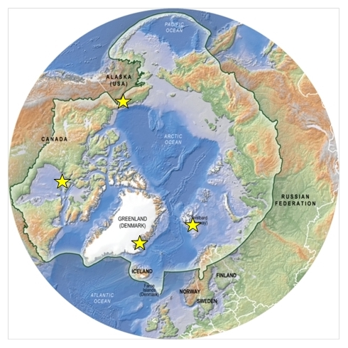 |
Figure 1.ACCES will synthesize existing environmental and biodiversity data and gain new knowledge from sites spanning over a wide geographical scale from the Pacific to the Atlantic Arctic (yellow stars).The drawn line in the map shows the Arctic region where the Conservation of Arctic Flora and Fauna (CAFF) addresses in their work. CAFF is a working group under the Arctic Council. Monitoring, assessment, protected areas and conservation strategies are all tasks under this working group. ACCES aim for close collaboration with CAFF. Source Grid Arendal. |
The selected model sites in this project are already sites of ongoing complementary research led by ACCES project’s partners (see CVs and budget forms). Our aim is to establish and harmonize long-term monitoring sites which are urgently needed for quantifying or detecting climate change impacts so we can better predict future biodiversity and social-ecological consequences of de-icing of Arctic coasts.
Division of work packages and individual tasks
This project comprises four well integrated work packages (WP) where all four partners will be actively involved in all WPs. In addition, the involvement of Denmark (M. Sejr and E. Møller, Aarhus University) with their expertise, extensive data, and ongoing research in coastal ecosystems in Greenland will strengthen the multidisciplinary consortium.WP1 Ecosystem drivers and primary producers
WP2 Biodiversity and food web structures
WP3 Climate scenarios
WP4 Social impacts and management
WP1 Ecosystem drivers and primary producers (CJ Mundy, Canada, K Dunton, US and A Hudson, Norway)
In order to understand the direct and indirect effects of de-icing in coastal ecosystems we need a detailed understanding of the physical environment and its impact on primary producers as the base of the food web. Few data are available regarding the interplay of physical and biological steering factors across the land-ocean interface in the Arctic. In WP1 we will determine the main abiotic factors shaping the primary producer communities and bloom phenology in iced versus ice-free/less extensively ice covered coastal rocky and soft sediment shore sites. Our focus is on how variability in sea ice, river run-off, coastal erosion, light and nutrient dynamics impacts primary producers. For example, loss of ice along the Arctic coast line has the potential to significantly increase underwater light availability, leading to favourable conditions for expansion of macroalgal communities, yet loss of ice algae. In areas of higher turbidity from increased riverine/glacial run-off and coastal erosion, however, light availability, and subsequently algal growth, will be suppressed. Higher freshwater input may also stress “native” primary producer communities, including both macro- and microalgae. The following working hypotheses (H) will be tested using a space for time approach:
WP1 - H1 Gradients in physical (sea ice, temperature, salinity, turbidity) and environmental (nutrients) conditions across sites will shift the balance between sympagic (ice algae), pelagic (phytoplankton) and benthic (microphytobenthos) microalgae in Arctic coastal regions through their impacts on blooming phenology, species composition, and biomass.
WP1 - H2 Less sea ice and ice scouring will lead to higher percent coverage, a broader depth range, and a more diverse macroalgal assemblage in the littoral zone. This enhancement in macroalgal growth should be observed in most areas, except those in the immediate vicinity of turbid glacial, river and coastal erosion plumes.
Physical drivers/ Abiotic parameters: Sea ice freeze-up, melt onset and ice break-up will be monitored by remote sensing (see WP3 below). Additionally, in situ field sampling during spring will provide information of sea ice properties during peak algal biomass (Leu et al 2015). Deployed over a year, small logger sensors will be used to record photosynthetically active radiation (PAR), temperature and salinity at depths between 5 and 15 m in close proximity to the shore line. Subsurface taut-line moored observatories are also available at a few of the Alaska, Canada, Greenland and Svalbard sites ensuring high-resolution background data on hydrography and in vivo fluorescence (proxy for Chlorophyll a) and for some, sea ice thickness, dissolved oxygen, pH and turbidity will be available. Water column profiles of PAR, salinity, temperature, density, turbidity and fluorescence will be measured via CTD casts (Saiv, model 208 or Searbird Scientific 19Plus). Water samples from 0, 5 and 15 m will be collected for nutrients and suspended sediments and dissolved organic matter.
Primary Producers: Macroalgal beds are an important part of marine coastal ecosystems, both as primary producers and habitat builders, protecting organisms from predators and currents. Macroalgae bind organic carbon for a longer time than short-living phytoplankton serving as a food source for benthic fauna all year round, being responsible for up to 20% of primary production in the shallow Arctic (Krause-Jensen et al 2012). Macroalgae growing on hard substrates will be intensively studied at the rocky shore study sites. In Greenland, growth and distribution of macroalgae has been shown to be directly related to the duration of the ice-free season (Krause-Jensen et al 2012). Same is evident in Svalbard, where an abrupt five- to eightfold increase in macroalgal cover has been detected in West Spitsbergen as seawater temperatures have increased and ice cover declined since 1980 (Kortsch et al 2012). These changes must be taken into account when evaluating the productivity and functioning of fjords and other coastal marine systems (Arrigo & van Dijken 2011). We will use a combination of methods (scuba diving, acoustics and video images) to determine kelp and seaweed coverage to map their distribution and depth zonation. Specimens will be collected for morphological identification to determine the biodiversity and fate of macroalgal beds in different coastal “climate scenarios”.
Tidal flats can be covered by dense “carpets” of microphytobenthos (MPB), mainly comprised of benthic diatoms (Wiktor et al 2016). In Arctic coastal habitats down to 30 m depth, benthic microalgal productivity may account for a substantial part of the overall primary production (Oakes et al 2016). The species biodiversity within these MPB communities and their ecological function is hardly known for high latitudes. MPB in the different ice coast scenarios will be collected by sampling surface sediments along a depth gradient with a small sediment corer suitable for small boat operations.
Ice algae can grow under very low light concentrations allowing these microalgae to start growing >2 months prior to the spring bloom of phytoplankton (Mundy et al 2014, Søreide et al 2010). Ice algae may only comprise a small fraction (e.g., 5-10% in the Canadian Arctic; (Michel et al 2006) of the total primary production, but its earlier bloom make these primary producers particularly important food for grazers to kick in reproduction after a long food-deplete winter (Søreide et al 2010). Samples of ice algae will be collected under different snow depths using an ice corer during peak bloom in spring to obtain an averaged site-specific estimate of net biomass accumulation over the spring (Mundy et al 2005).
Phytoplankton dynamics often not considered in detail within shallow coastal zones of the Arctic, where ice-breakers and other deep-water oceanographic ships cannot access to deploy their rosettes. Near-shore water samples will thus be sampled using Niskin bottles at 0, 5 and 15 m depths at each of the sites. Ice algae will be sampled by sea ice coring. Microalgae biodiversity will be determined morphologically according to (Kubiszyn et al 2017) and by metabarcoding (see WP2 below).
Other standing stock parameters such as Chlorophyll a and particulate organic carbon and nitrogen (POC/PON) will be taken and bulk stable isotopes (carbon and nitrogen) will be analysed to determine the food web baseline and carbon source signature of the 4 main primary producers across the Arctic and across different “climate and sea ice scenarios” on local, regional and pan-Arctic scale as described in (Iken et al 2010, Søreide et al 2013) (see WP2). Additionally, the potential presence of unique bio-markers for different algal communities will be explored in an effort to provide an estimate of the relative contribution of algal community sources for higher trophic levels (e.g., h-print method; (Brown et al 2014). For more information on food web structures see WP2 below.
WP2 Biodiversity and food web structures (K Iken, US, JE Søreide, Norway and M Sejr, Denmark)
High biodiversity and complex food web structures are typically viewed as agents of stability and resilience in coastal habitats due to niche complementarity and effective use of resources (e.g. (Elmqvist et al 2003). We will determine the biodiversity of pelagic, benthic and sea ice realms and trophic structures in soft sediment and rocky coastal ecosystems with contrasting sea ice conditions. We will focus on how primary consumers, i.e., small metazoans living in sea ice, the water column, and on the seafloor (infauna), utilize the various sources of primary production (see WP1) in these coastal Arctic systems.
Main hypotheses
WP2 – H1 Sea ice is an important nursery ground for larvae of benthic invertebrates. Loss of the sea ice habitat will thus have negative consequences on both biodiversity and abundance of “true” Arctic benthic infauna species in high-Arctic coastal ecosystems.
WP2 – H2 Less sea ice and longer exposure to river-runoff will change the zooplankton community to a more brackish one that is less species- and energy-rich due to smaller body sizes.
WP2 – H3 Less sea ice and ice scouring will have positive effects on faunal diversity and biomass at high-Arctic rocky shore sites.
WP2 – H4 A change from a cold Arctic to a warmer sub-Arctic climate will lead to higher biodiversity and a more stable and resilient coastal ecosystem despite that true Arctic species may be disappearing.
Sea ice: Brine channels, which form due to the exclusion of salt ions from the ice crystal matrix during freeze-up, make up the habitat for a wide variety of viruses, bacteria, fungi, algae and proto- and metazoan meiofauna (Bluhm et al 2011, Marquardt et al 2011). Ice algae provide nutritious food for meiofaunal organisms capable of entering the brine channels, which also provide them refuge from larger predators. Very limited studies of these sea ice communities exist from coastal sea ice, with the exception of a few studies from the Alaskan coast line (Gradinger et al 2009). So far, there are indications of sea ice being an important nursery ground for some meroplanktic larvae (Bluhm et al 2018, McConnell et al 2012).
Pelagic: Coastal waters can have steep gradients in salinity and high sediment loads making the environment stressful for zooplankton species. Brackish waters are often characterized by smaller and less lipid-rich species compared to marine environments dominated by large, lipid-rich copepods of the genus Calanus (Middelbo et al 2018). Zooplankton biomass in nearshore, shallow waters are therefore normally low, but may temporarily be dominated by tiny benthic larvea (meroplankton) when phytoplankton is plentiful (Stubner et al 2016).
Benthic invertebrate communities are highly diverse, but often only a few species dominate in extreme habitats (Weslawski et al 1993). We will determine valid indicator species for different substrates (rocky and soft) and sea ice climate scenarios on local, regional and a wider pan-Arctic scale, with a special focus on potentially rare and invasive species.
Sampling: We will target our spring sampling to the ice algal and phytoplankton bloom and our summer sampling to post-bloom conditions to ensure that we representatively capture the biodiversity in the dynamic sea ice and pelagic environments. For the less fluctuating benthic environment only summer sampling will be performed.
Sea ice will be sampled with ice cores, which will be melted in filtered seawater to avoid osmotic shock. Live organisms from melted sea ice cores will be identified to the lowest possible taxonomic level under a stereomicroscope (Leica MS 5, 40x magnification), counted and photographed, and either stored individually in 80% ethanol or frozen for later molecular analyses. If two or more individuals of the same species are present, a parallel sample will be stored and preserved for taxonomic reference. Zooplankton will be sampled with vertical net hauls using regular WP2 nets with two different mesh sizes (20 µm and 60µm). Benthic fauna will be sampled with small van veen grabs for soft bottom communities and small triangle dredges and picking within a defined area (0.5m-2) in rocky shore sites. The aim of the sampling program is to obtain a standardised data set that allows (regional and local) comparison across sites with varying ice conditions. Thus, within the logistic constraints of working in the Arctic we aim to conduct the outlined sampling program at the study sites identified in Fig.1.
The biodiversity of communities of microalgae (phytoplankton and ice algae) and smaller metazoans will also be investigated using DNA metabarcoding from bulk samples in seawater filtered onto 0.45 um pore size filters. Metabarcoding increases the ability to genetically discriminate small organisms (Lindeque et al 2013) and species with very low abundance such as early invaders, which may be missed by traditional identifications (Darling& Mahon 2011). DNA will be extracted using Plant (ice algae, phytoplankton) or the Qiagen Blood& Tissue (zooplankton) kits, PCR-amplified with appropriate primers (mitochondrial COI or nuclear 18S rDNA for zooplankton; nuclear 18S rDNA for phytoplankton), and sent for paired-end Illumina sequencing. Standard bioinformatics workflows (i.e. the Usearch pipeline, Edgar 2010) will be used to quality check the sequences and cluster them into operational taxonomic units (OTUs). Taxonomy will be assigned by Blast -searching (Altschul et al 1990) the OTUs against suitable databases (i.e., NCBI or PR2). For selected ice algae and plankton samples we will also conduct traditional microscopy work (see WP1) to identify the species diversity and community structure. Food web structures and consumers main carbon sources will be determined with stable carbon and nitrogen isotope analyses. Samples of primary producers and consumers from all realms will be collected and dried at 60°C for 24h. Samples will then be treated for carbonates and lipid removal as needed and re-dried. The 13C:12C and 15N:14N ratios will be measured using continuous-flow isotope ratio mass spectrometry (IRMS) at the University of California (http://stableisotopefacility.ucdavis.edu/). Isotope values will be expressed in the common delta notation in parts per thousand (‰) following:
WP3 Climate scenarios (J.M. Węsławski, Poland, Bélanger, Canada and Poste, Norway)
Remote sensing and modelling will in this study be used to generalize our results from local to a wider geographical pan-Arctic scale. In situ data from field sampling (WP1) will be actively used to validate remote sensing data, which may be challenging to use due to close proximity to land and terrigenous inputs disturbing correct interpretation of the images. Physical drivers change (coastal ice cover) and species distribution modelling will answer how the biotic system responds to the physical one.
Main hypotheses
WP3 H1 The coastal ice change occurs faster than the biotic response may follow, furthermore de- icing is directly related to the marine climate, while the biotic response is an interplay between local species and new immigrants.
WP3 H2 Remote sensing can be used to identify different Arctic coastal climate systems and determine the geographical extent/ relative importance of these different systems across the Arctic.
Remote sensing and modelling: Water colour in coastal environments, as detected from space-borne multi-spectral sensors, is driven by three types of optically active constituents: phytoplankton, colored dissolved organic matter (CDOM) and non-living particulate matter (mineral or organic). In shallow waters, bottom and vegetation may also contribute to the water-leaving signal measured from space. The new generation of high resolution (10 to 30 meters) multi-spectral satellite such as Landsat-8 (Fig. 3) and Sentinel-2 can provide maps of useful optical proxies (e.g. Chl a, total suspended sediments, CDOM, and sometimes near shore vegetation indices) in the coastal zone, including vertical diffuse light attenuation coefficient (Kd). Combined with emergent technologies such as the nanosatellites (e.g. from Planet Labs https://www.planet.com/) equipped with 4-bands camera (RGB+NIR), we now have almost daily coverage at very high spatial resolution (4 m) allowing us to study very dynamic environments. These unprecedented data sets will provide useful insights on the dynamic and the spatial and temporal variability of these key environmental parameters.
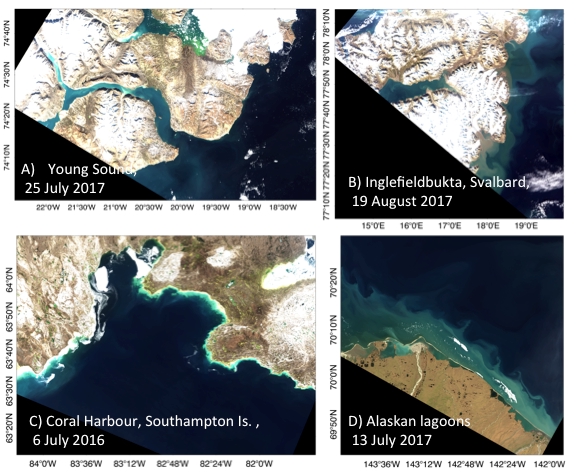 |
Figure 2.Landsat images of the studied sites in true color composite showing contrasting patterns in terms of suspended sediments and shorelines. |
Ecosystems productivity largely relies on light availability. Therefore, optical remote sensing will be combined to passive microwaves and thermal infrared as well as active remote sensing (SAR) for shore ice and cloud cover mapping in order to model incident PAR in the coastal environment. This will be achieved by adapting a satellite-based approach developed by to model Arctic primary production (Belanger et al 2013, Laliberte et al 2016). The adapted satellite-based PAR model will provide daily PAR at the sea surface. In addition, we will attempt to assess PAR available for bottom habitats using satellite-derived diffuse light attenuation coefficient (Kd). Those modeled PAR will be validated using in situ PAR measurements and applied to assess PAR other key arctic coastal sites. The GIS analyses of satellite imagery strengthened by surface validation will be used for the species and habitat modelling that will serve to update e.g. the old assessment of Svalbard coastal zone vulnerability for hazards like an oil spill (Weslawski et al 1997). Bayesian Network (BN) modelling define relationships between stressors and endpoints based on information from several sources (e.g. empirical data, expert judgment, existing statistical and mechanistic models, and stakeholder inputs), and will be used to characterize complex systems, relationships and processes in coastal nearshore Arctic ecosystems (Chen& Pollino 2012) that will be spatially applied (through incorporation of GIS data).
WP4 Social impacts and management Several of the principles guiding the Ecosystem Approach under the Convention of Biological Diversity are relevant for stakeholder involvement and engagement - not only in policy and management - but also in knowledge production, including principle 11, which states that one should “consider all forms of relevant information, including scientific and indigenous and local knowledge, innovations and practices”, as well as highlighting the importance of information sharing with all stakeholders and actors; principle 12, calling for the involvement of all relevant sectors of society and scientific disciplines; and not least principle 1, acknowledging that “The objectives of management of land, water and living resources are a matter of societal choices” (our underlining).
The extent and timing of interactions between science and stakeholders may vary considerably (Figure 3), but for approaching the CBD ambitions, some version of models 4 or 5 in figure 3 must generally be achieved. One could for example envisage a periodical engagement of stakeholders (rather than the “continual engagement” of model 5) at critical junctures in a management-oriented research project.
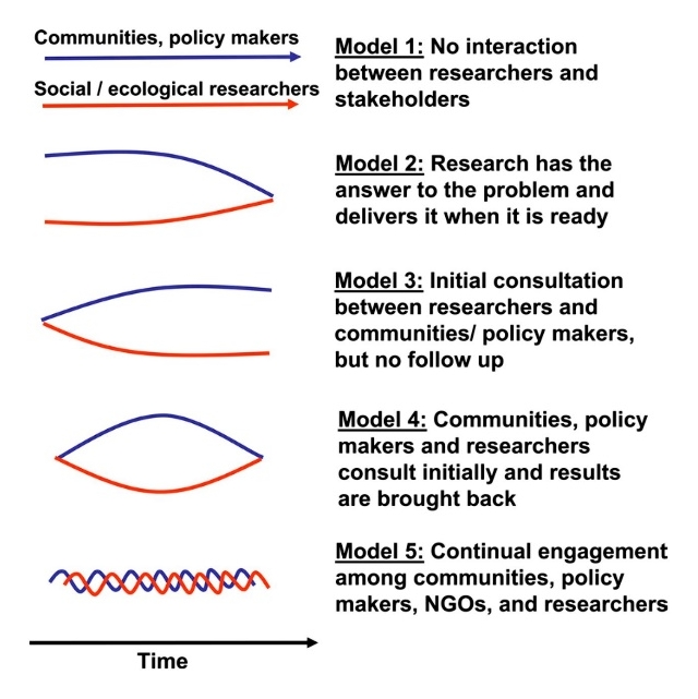 |
Figure 3. Different models for linking knowledge and action in research based management. (Reid et al 2016) |
As (Berghöfer et al 2008) note with regard to fisheries management, ecosystem-based management (EBM) approaches pose “special challenges for information management, as it is a matter of societal negotiation to determine different expectations and uses of our seas”. Stakeholder involvement is thus both necessary and challenging in such settings.
The first step in our analysis will be stakeholder mapping that will be done through a one day workshop in Tromsø, attended by the team members and invited experts. The workshop will use an expert brainstorming techniques to identify and map key stakeholders to be engaged in the next stages. Having identified the key stakeholders we will, in the second step, conduct a detailed and targeted electronic survey and follow-up in-depth interviews with primary stakeholders over phone or Internet-based communicators.
The third step will be to examine how different de-icing scenarios will affect the identified stakeholders in defined coastal areas, this project will use a framework developed under the Millennium Ecosystem Assessment (MEA 2005) that links major ecosystem services (supporting, provisioning, regulating, and cultural) with constituents of well-being (security, basic material for good life, health, good social relations, freedom of choice and action) extended to include also economic, governance and political aspects, which are essential for effective future coastal management.
To build plausible, distinct, consistent, challenging scenarios with decision-making utility (Ringland 1998, Schwartz 1996) an exploratory scenario-building logic will be applied based on results and findings from the other work packages, but also employing an “Intuitive Logics” method (Kosow& Gassner 2008) that allows for a focus on decision-making processes and takes into account not only unpredictability but also every piece of available information about the future in order to recognize inherent structures and develop new ideas (Wilson 1998). In doing so, this work package research will rely not only on variables and parameters related to ecosystem drivers (WP 1), biodiversity and food web structures (WP 2) and different climate scenarios (WP 3), but will also include those suggested by stakeholders as “experts” (obtained in the survey and interviews) that are of crucial importance for certain areas as based on local and traditional knowledge to construct scenarios for social impacts of these changes. Once the key variables and parameters are identified and ranked according to impact/uncertainty matrix (likely labelled as ‘High-Medium-Low’), the axes for scenario constructing will be developed that will indicate the scenarios’ logics. This method will also provide for better accommodation of uncertainty factors related to stakeholders’ livelihood and activities. By applying this method to scenario-building related to direct and indirect drivers, it will be possible to better understand how the changes in biodiversity and ecosystem services will affect different stakeholders in defined coastal areas, and thus to develop better models of impacts. This will provide for coupling social and ecological components of models (including feedbacks) and will be of paramount importance for strengthening the decision-making processes related to adaptation.
The fourth and final step will be receiving feedback to further fine-tune the scenarios and to make them more applicable for possible decision- and policy-making purposes. This will be done either by a joint workshop with selected stakeholders and experts (additional event funding to be sought from the Research Council of Norway and the Fram Centre) or, if funding applications are unsuccessful, through electronic communications (teleconference or individual meetings/talks).
Stakeholder analysis: Given increased and predictable access to open sea, a number of both new and established industries (e.g. fisheries, shipping, tourism, mining, gas and oil). may see new potentials for increasing their use of arctic waters. And as (Newton et al 2016) point out, various forms of infrastructure will be required to support these new developments. This may lead to undesired environmental impacts, and/or conflicts due to competition over both marine, coastal and terrestrial space. To make developments sustainable it is of high importance to to identify the actual, as well as the potential, stakeholders, analyse their development strategies, and bring ecosystem knowledge to bear on decisions regarding the use of arctic coastal waters and resources (Buanes et al 2004).
Relevance for the policy application
Diverse communities are more likely to exploit a broader range of resources (niche complementarity) ensuring that different taxa can step in following disturbance to maintain ecosystem functions resulting in a resilient ecosystem. Basic assessment of coastal biodiversity and state of processes, needed for future management decisions.
Description of stakeholder engagement and identification of end-user project results
To ensure that the knowledge generated in this project is incorporated in coastal management and communicated to stakeholders we have social scientists in our project team and an own work package (WP4) dedicated to this important task.
Proposed exploitation of results, and knowledge transfer to practitioners, policy- and decision-makers
This project is of high relevance for developing local and national management plans and for the Arctic in general - the Coastal Plan that the Coastal Expert Monitoring Group under CAFF is currently being developed. One project member (Renaud) is a member of the expert group writing the monitoring plan guidelines to be recommended to the Arctic Council. The work proposed here already fits well into priorities of this developing plan, and we will be sure that our work will fill some of the monitoring targets to be established.
Communication of results to practitioners, policy- and decision-makers
Results from this project will be published in peer-reviewed journals and communicated at international scientific conferences. Popular scientific publications will also be prioritized as well as open meetings to ensure that the project knowledge reach out to stakeholders, policy- and decision-makers. One meeting we will target is Arctic Frontiers, the largest annual conference where scientists, industry, and policy makers interact.
International added value of research proposed and transnational collaboration
The ACCES project has a clear added value to ongoing Norwegian, Polish, Canadian, US and Danish national marine research projects across the Arctic by linking expertise and efforts across national teams and across studied areas. This allows matching needs of stakeholders and research products at local and regional levels, optimization and standardization of methods, and general increase in comparable and ecosystem-relevant understanding of the levels and consequences of changing biodiversity, spanning both the Pacific and the Atlantic sides of the Arctic.
References
- Altschul SF, Gish W, Miller W, Myers EW, Lipman DJ. 1990. Basic local alignment search tool Journal of Molecular Biology 215: 403-10
- Arrigo KR, van Dijken GL. 2011. Secular trends in Arctic Ocean net primary production. Journal of Geophysical Research-Oceans 116
- Belanger S, Cizmeli SA, Ehn J, Matsuoka A, Doxaran D, et al. 2013. Light absorption and partitioning in Arctic Ocean surface waters: impact of multiyear ice melting. Biogeosciences 10: 6433-52
- Berghöfer A, Wittmer H, Rauschmayer F. 2008. Stakeholder participation in ecosystem-based approaches to fisheries management: A synthesis from European research projects. Marine Policy 32: 243-53
- Bluhm BA, Gebruk AV, Gradinger R, Hopcroft RR, Huettmann F, et al. 2011. Arctic Marine Biodiversity: An Update of Species Richness and Examples of Biodiversity Change. Oceanography 24: 232-48
- Bluhm BA, Hop H, Vihtakari M, Gradinger R, Iken K, et al. 2018. Sea ice meiofauna distribution on local to pan-Arctic scales. Ecology and Evolution 8: 2350-64
- Brown TA, Galicia MP, Thiemann GW, Belt ST, Yurkowski DJ, Dyck MG. 2018. High contributions of sea ice derived carbon in polar bear (Ursus maritimus) tissue. PLOS ONE 13: e0191631
- Brown TA, Yurkowski DJ, Ferguson SH, Alexander C, Belt ST. 2014. H-Print: a new chemical fingerprinting approach for distinguishing primary production sources in Arctic ecosystems. Environmental Chemistry Letters 12: 387-92
- Buanes A, Jentoft S, Karlsen GR, Maurstad A, Soreng S. 2004. In whose interest? An exploratory analysis of stakeholders in Norwegian coastal zone planning. Ocean& Coastal Management 47: 207-23
- CAFF. 2013. Life linked to ice: a guide to sea ice associated biodiversity in this time of rapid change. pp. 116
- Chen SH, Pollino CA. 2012. Good practice in Bayesian network modelling. Environmental Modelling& Software 37: 134-45
- Darling JA, Mahon AR. 2011. From molecules to management: Adopting DNA-based methods for monitoring biological invasions in aquatic environments. Environmental Research 111: 978-88
- Elmqvist T, Folke C, Nyström M, Peterson G, Bengtsson J, et al. 2003. Response diversity, ecosystem change, and resilience. . Frontiers in Ecology and the Environment 1: 488-94
- Gradinger R, Kaufman M, Bluhm B. 2009. Pivotal role of sea ice sediments in the seasonal development of near-shore Arctic fast ice biota. Marine Ecology Progress Series 394: 49-63
- Hussey NE, MacNeil MA, McMeans BC, Olin JA, Dudley SFJ, et al. 2014. Rescaling the trophic structure of marine food webs. Ecology Letters 17: 239-50
- Iken K, Bluhm B, Dunton K. 2010. Benthic food-web structure under differing water mass properties in the southern Chukchi Sea. Deep Sea Research Part II: Topical Studies in Oceanography 57: 71-85
- Kortsch S, Primicerio R, Beuchel F, Renaud PE, Rodrigues J, et al. 2012. Climate-driven regime shifts in Arctic marine benthos. Proceedings of the National Academy of Sciences of the United States of America 109: 14052-57
- Kosow H, Gassner R. 2008. Methods of Future and Scenario Analysis: Overview, Assessment, and Selection, Bonn
- Krause-Jensen D, Markager S, Dalsgaard T. 2012. Benthic and Pelagic Primary Production in Different Nutrient Regimes. Estuaries and Coasts 35: 527-45
- Kubiszyn AM, Wiktor JM, Wiktor JM, Griffiths C, Kristiansen S, Gabrielsen TM. 2017. The annual planktonic protist community structure in an ice-free high Arctic fjord (Adventfjorden, West Spitsbergen). Journal of Marine Systems 169: 61-72
- Laliberte J, Belanger S, Frouin R. 2016. Evaluation of satellite-based algorithms to estimate photosynthetically available radiation (PAR) reaching the ocean surface at high northern latitudes. Remote Sensing of Environment 184: 199-211
- Lantuit H, Atkinson D, Overduin PP, Grigoriev MN, Rachold V, et al. 2011. Coastal erosion dynamics and storm characteristics of Bykovsky Peninsula. In Supplement to: Lantuit, H et al. (2011): Coastal erosion dynamics on the permafrost-dominated Bykovsky Peninsula, north Siberia, 1951-2006. Polar Research, 30, 7341, https://doi.org/10.3402/polar.v30i0.7341: PANGAEA
- Leu E, Mundy CJ, Assmy P, Campbell K, Gabrielsen TM, et al. 2015. Arctic spring awakening - Steering principles behind the phenology of vernal ice algal blooms. Progress in Oceanography 139: 151-70
- Lindeque PK, Parry HE, Harmer RA, Somerfield PJ, Atkinson A. 2013. Next Generation Sequencing Reveals the Hidden Diversity of Zooplankton Assemblages. Plos One 8
- Marquardt M, Kramer M, Carnat G, Werner I. 2011. Vertical distribution of sympagic meiofauna in sea ice in the Canadian Beaufort Sea. Polar Biol 34: 1887-900
- McConnell B, Gradinger R, Iken K, Bluhm BA. 2012. Growth rates of arctic juvenile Scolelepis squamata (Polychaeta: Spionidae) isolated from Chukchi Sea fast ice. Polar Biol 35: 1487-94
- MEA. 2005. Ecosystems and Human Well-being: Synthesis. Washington, DC: Island Press. Michel C, Ingram RG, Harris LR. 2006. Variability in oceanographic and ecological processes in the Canadian Arctic Archipelago. Progress in Oceanography 71: 379-401
- Middelbo AB, Sejr MK, Arendt KE, Moller EF. 2018. Impact of glacial meltwater on spatiotemporal distribution of copepods and their grazing impact in Young Sound NE, Greenland. Limnology and Oceanography 63: 322-36
- Miller AW, Ruiz GM. 2014. Arctic shipping and marine invaders. Nat. Clim. Chang. 4: 413
- Mouillot D, Villeger S, Scherer-Lorenzen M, Mason NWH. 2011. Functional Structure of Biological Communities Predicts Ecosystem Multifunctionality. Plos One 6
- Mundy CJ, Barber DG, Michel C. 2005. Variability of snow and ice thermal, physical and optical properties pertinent to sea ice algae biomass during spring. Journal of Marine Systems 58: 107-20
- Mundy CJ, Gosselin M, Gratton Y, Brown K, Galindo V, et al. 2014. Role of environmental factors on phytoplankton bloom initiation under landfast sea ice in Resolute Passage, Canada. Marine Ecology Progress Series 497: 39-49
- Newton R, Pfirman S, Schlosser P, Tremblay B, Murray M, Pomerance R. 2016. White Arctic vs. Blue Arctic: A case study of diverging stakeholder responses to environmental change. Earth's Future: 396-405
- Oakes JM, Rysgaard S, Glud RN, Eyre BD. 2016. The transformation and fate of sub-Arctic microphytobenthos carbon revealed through C-13-labeling. Limnology and Oceanography 61: 2296-308
- Post DM. 2002. Using stable isotopes to estimate trophic position: models, methods, and assumptions. Ecology 83: 703-18
- Ringland G. 1998. Scenario Planning: Managing for the Future. . Chichester: Wiley.
- Schwartz P. 1996. The Art of the Long View: Planning for the Future in an Uncertain World.
- Sejr MK, Stedmon CA, Bendtsen J, Abermann J, Juul-Pedersen T, et al. 2017. Evidence of local and regional freshening of Northeast Greenland coastal waters. Scientific Reports 7
- Stubner EI, Soreide JE, Reigstad M, Marquardt M, Blachowiak-Samolyk K. 2016. Year-round meroplankton dynamics in high-Arctic Svalbard. Journal of Plankton Research 38: 522-36
- Søreide JE, Carroll ML, Hop H, Ambrose WG, Hegseth EN, Falk-Petersen S. 2013.
- Sympagic-pelagic-benthic coupling in Arctic and Atlantic waters around Svalbard revealed by stable isotopic and fatty acid tracers. Marine Biology Research 9: 831-50
- Søreide JE, Leu E, Berge J, Graeve M, Falk-Petersen S. 2010. Timing of blooms, algal food quality and Calanus glacialis reproduction and growth in a changing Arctic. Glob. Change Biol. 16: 3154-63
- Węsławski JM, Wiktor J, Zajączkowski M, Swerpel S. 1993. Intertidal zone of Svalbard. 1 Macroorganisms distribution and bomass Polar Biol 13: 73-79
- Węsławski JM, Zajączkowski M, Wiktor J, Szymelfenig M. 1997. Intertidal Zone of Svalbard .3. Littoral of a Subarctic, Oceanic Island: Bjornoya. Polar Biol 18: 45-52
- Wiktor J, Tatarek A, Węsławski JM, Kotwicki L, Poulin M. 2016. Colonies of Gyrosigma eximium: a new phenomenon in Arctic tidal flats. Oceanologia 58: 336-40
- Wilson IMMotfAILAtSP, in: L. Fahey and R. M. Randall (eds), Learning from the Future: Competitive Foresight Scenarios, New York: Wiley, pp: 81–108. 1998. Mental Maps of the future: An Intuitive Logigs Approach to Scenario Planning in Learning from the Future: Competitive Foresight Scenarios. pp. 81-108. New York: Wiley.