Field work - intertidal 2022
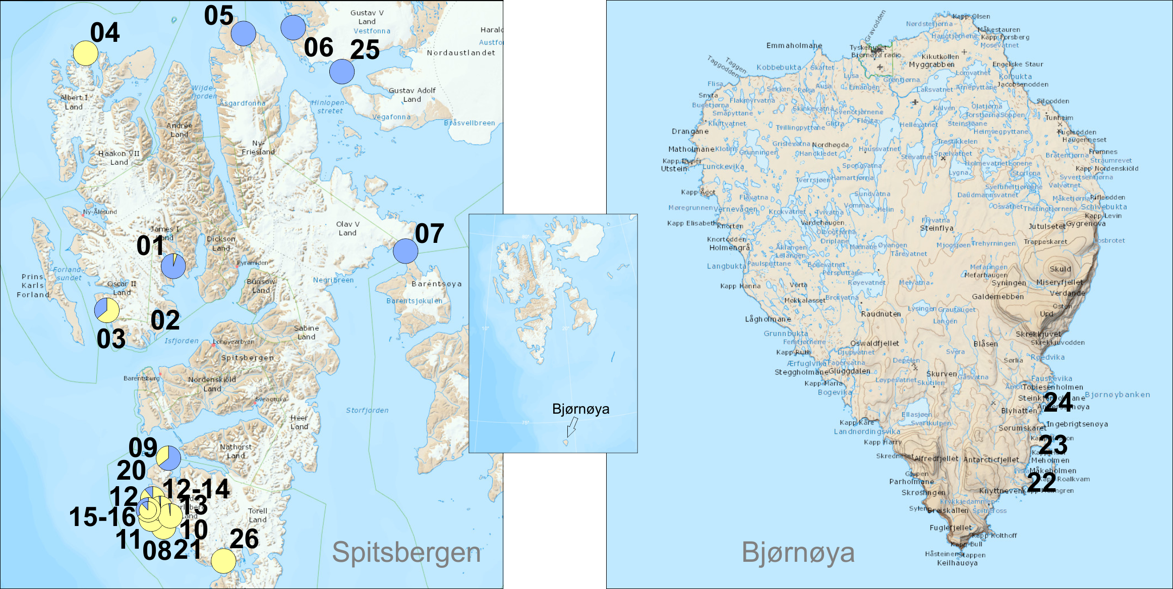 |
| nr | campaign | date | place name | latitude | longitude | Gam. ocea- nicus | Gam. seto- sus | G. ocea- nicus % | G. seto- sus % | coast- type | Fucus | Litto- rina | Semi- bala- nus | photo | finder |
| 01 | Isfjorden | 24.08. 2022 | Ekmanfjorden | 78°40.016 | 14°34.400 | 3 | 56 | 5 | 95 | sheltered, stony beach | | J.M. Węsławski | |||
| 02 | Isfjorden | 25.08. 2022 | Borebukta | 78°22.445 | 14°17.839 | 0 | 0 | tidal flat | x | x | | L. Kotwicki | |||
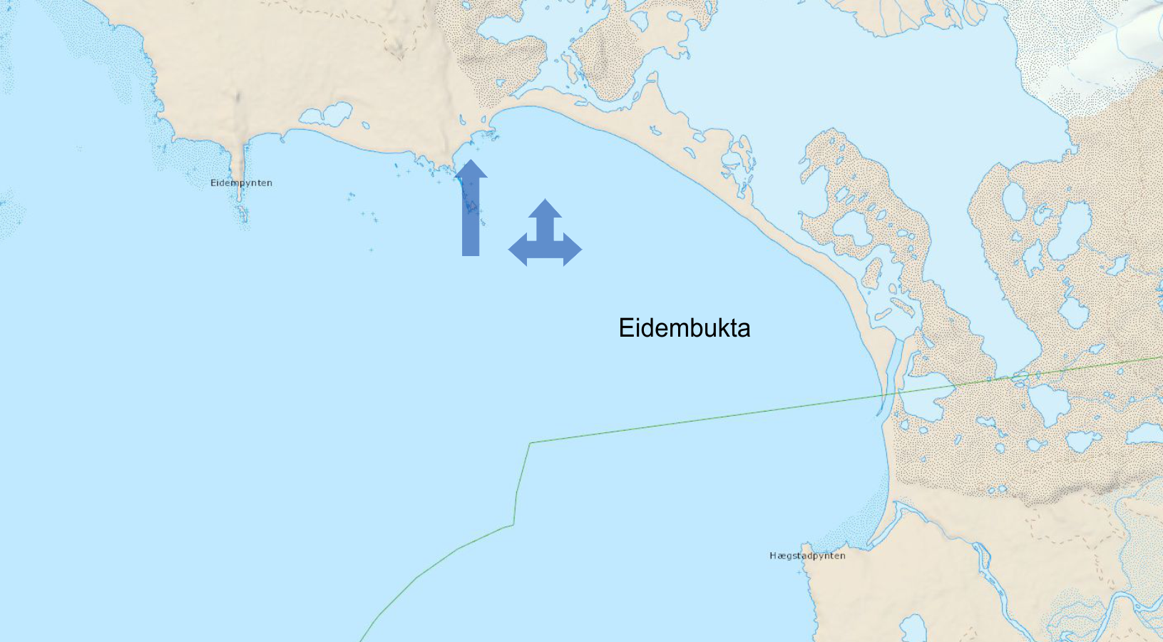
| 03 | Isfjorden | 26.08. 2022 | Eidembukta | 78°21.680 | 12°47.404 | 76 | 42 | 64 | 36 | exposed, skjerra, gravel, sand | x | x | x | | J.M. Węsławski |
| 04 | Circum- svalbard | 03.09. 2022 | Sallyhamna, Svenskegattet | 79.81711 | 11.59750 | 61 | 0 | 100 | 0 | stones, semi sheltered | x | x | | R. Siwecki | |
| 05 | Circum- svalbard | 04.09. 2022 | Eolusneset, Sorgfjorden | 79.94113 | 16.72127 | 0 | 51 | 0 | 100 | stones, semi sheltered, Pilayella | | R. Siwecki | |||
| 06 | Circum- svalbard | 05.09. 2022 | Krokoya, Murchisonfjorden | 79.95300 | 18.41562 | 0 | 50 | 0 | 100 | rock, stones, Pilayells, semisheltered | x | | R. Siwecki | ||
| 07 | Circum- svalbard | 06.09. 2022 | Heleysundet | 78.68204 | 21.07129 | 0 | 26 | 0 | 100 | rock, stones, Pilayells, semisheltered | | R. Siwecki | |||
| 08 | Circum- svalbard | 08.09. 2022 | Palffyodden, Hornsund | 76.89848 | 15.51931 | 85 | 0 | 100 | 0 | skjerra, stones, Pilayella, exposed | x | x | | R. Siwecki | |
| 09 | Circum- svalbard | 09.09. 2022 | Skilvika, Bellsund | 77.57135 | 14.41491 | 13 | 30 | 30 | 70 | exposed, Pilayella, Chordaria | x | | R. Siwecki | ||
| 10 | SW Spitsbergen | 31.07. 2022 | Veslebukta | 77°14.250' | 14°19.453' | 39 | 0 | 100 | 0 | exposed, skjerra, gravel, sand | T. Jankowski | ||||
| 11 | SW Spitsbergen | 31.07. 2022 | Vassodden | 77°14.588' | 14°18.260' | 84 | 0 | 100 | 0 | exposed, skjerra, gravel, sand | T. Jankowski | ||||
| 12 | SW Spitsbergen | 01.08. 2022 | Ravlbukta | 77°24.688' | 13°58.483' | 70 | 9 | 89 | 11 | exposed, skjerra, gravel, sand | x | T. Jankowski | |||
| 13 | SW Spitsbergen | 01.08. 2022 | Fonhusbukta | 77°20.265' | 14°08.810' | 107 | 2 | 98 | 2 | exposed, skjerra, gravel, sand | T. Jankowski | ||||
| 14 | SW Spitsbergen | 01.08. 2022 | Ravlbukta | 77°24.689' | 13°58.479' | 9 | 4 | 69 | 31 | exposed, skjerra, gravel, sand | T. Jankowski | ||||
| 15 | SW Spitsbergen | 02.08. 2022 | Dunderbukta | 77°28.338' | 14°01.801' | 2 | 1 | 66 | 33 | exposed, skjerra, gravel, sand | T. Jankowski | ||||
| 16 | SW Spitsbergen | 02.08. 2022 | Dunderbukta | 77°28.338' | 14°01.801' | 70 | 16 | 81 | 11 | exposed, skjerra, gravel, sand | x | T. Jankowski | |||
| 17 | SW Spitsbergen | 02.08. 2022 | Logna (river) outlet | 77°31.298' | 13°55.117' | 64 | 0 | 100 | 0 | exposed, skjerra, gravel, sand | x | T. Jankowski | |||
| 18 | SW Spitsbergen | 03.08. 202 | Tomtvika | 77°32.076' | 13°56.837' | 31 | 6 | 84 | 16 | exposed, skjerra, gravel, sand | T. Jankowski | ||||
| 19 | SW Spitsbergen | 04.08. 2022 | Rochesterpynten | 77°34.724' | 14°17.187' | x | x | x | x | exposed, skjerra, gravel, sand | x | T. Jankowski | |||
| 20 | SW Spitsbergen | 02.08. 2022 | Logna (river) outlet | 77°31.298' | 13°55.117' | x | x | x | x | exposed, skjerra, gravel, sand | x | x | T. Jankowski | ||
| 21 | SW Spitsbergen | 01.08. 2022 | Fonhusbukta | 77°20.424' | 14°08.857' | x | x | x | x | exposed, skjerra, gravel, sand | T. Jankowski | ||||
| 22 | Bjørnøya 1 | 12.07. 2022 | Bjørnøya, Kvalrosbukta | 74°22'21.9" | 19°10'19.8" | 0 | 0 | exposed rock, Fucus, Pilayella, chlorophyta | x | x | | P. Bałazy | |||
| 23 | Bjørnøya 2 | 13.07. 2022 | Bjørnøya, Iversenbukta/ Sorhamna | 74°21'36.8" | 19°08'55.0" | 0 | 0 | exposed rock, Fucus, Pilayella, chlorophyta | x | x | | P. Bałazy | |||
| 24 | Bjørnøya 3 | 13.07. 2022 | Bjørnøya, Rusehamna/ Longvika | 74°23'06.1" | 19°10'44.2" | 0 | 0 | exposed rock, Fucus, Pilayella, chlorophyta | x | x | | P. Bałazy | |||
| 25 | Nordaustalandet | 09.05. 2022 | Wahlenbergfjorden/ Gyldenoyane | 79°41.384' | 19°43.624' | 0 | 19 | 0 | 100 | sheltered, stony beach | J. Soreide | ||||
| 26 | Sorkappland | 09.10. 2022 | Gnalodden/ Hornsund | 77°00.885 | 15°52.026 | 26 | 0 | 100 | 0 | rock, stones, Pilayella, semisheltered | J. Soreide |
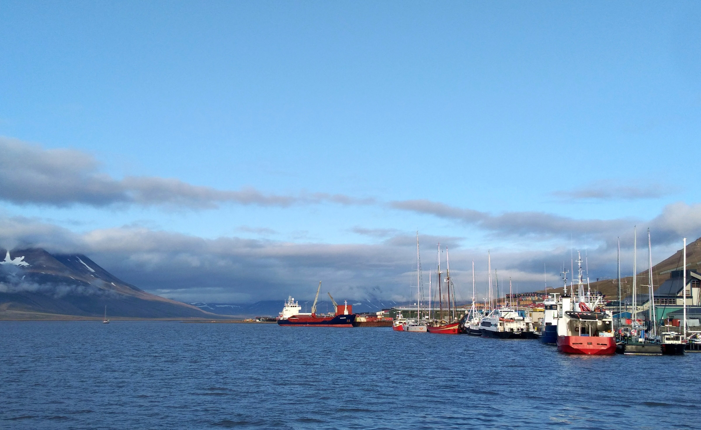
Isfjorden 2022 August sampling from OCEANIA — field work blog
Maps
 |
 |
 |
 |
Coastal ponds sampling
| date | time | place name | latitude | longitude |
| 2022-08-24 | 14.15-11.00 | Coraholmen/Ekmanfjorden | 78°40.015' | 14°42.661' |
| number | salinity | temperature | pH | nutrients | macrofauna | plankton | diatoms | photo |
| pond 1 | 6.9 | 5.5 °C | 8.2 | x | x | x | ||
| pond 2 | 6.3 | 5.5 °C | 8.4 | x | x | x | ||
| pond 3 | 9.2 | 5.5 °C | 8.4 | x | x | x | ||
| pond 4 | 4.6 | 5.5 °C | 8.5 | x | x | x | x | |
| pond 5 | 16 | 5.5 °C | 8.4 | x | x | x |
| date | time | place name | latitude | longitude |
| 2022-08-25 | 14.00-11.00 | Tundraodden/Borebukta | 78°20.190' | 14°13.405' |
| number | salinity | temperature | pH | nutrients | macrofauna | plankton | diatoms | photo |
| pond 1 | 0 | 6.8 °C | 8.4 | x | x | x | ||
| pond 2 | 0 | 6.8 °C | 8.7 | x | x | x | ||
| pond 3 | 1.4 | 6.8 °C | 8.73 | x | x | x | ||
| pond 4 | 1.33 | 6.8 °C | 8.67 | x | x | x | x | |
| pond 5 | 10.6 | 6.8 °C | 8.47 | x | x | x |
| date | time | place name | latitude | longitude |
| 2022-08-26 | 14.30-24.00 | Eidembukta/Eidembukta | 78°22.434' | 12°45.105' |
| number | salinity | temperature | pH | nutrients | macrofauna | plankton | diatoms | photo |
| pond 1 | 0.13 | 7.0 °C | 9.13 | x | x | x | ||
| pond 2 | 0.52 | 7.0 °C | 8.62 | x | x | x | ||
| pond 3 | 0.42 | 7.0 °C | 8.64 | x | x | x | ||
| pond 4 | 0.14 | 7.0 °C | 8.85 | x | x | x | x | |
| pond 5 | 0.26 | 7.0 °C | 8.64 | x | x | x |
Tidal sampling
| date | time | place name | latitude | longitude | activities | activities | activities | activities | activities coastal | photo |
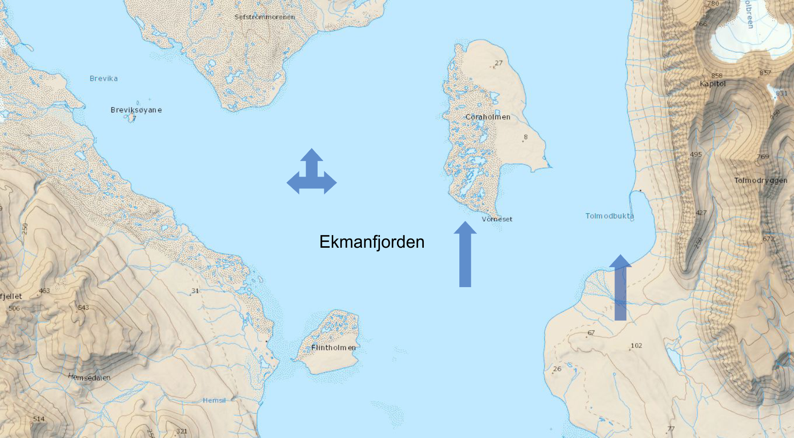
| 2022-08-24 | 14.15-11.00 | Ekmanfjorden | 78°40.016 | 14°34.400 | lander/bait/camera 30 m | plastic count | tidal flat sampling | seabed photo-profile 5.15, 30 m | coastal ponds | |
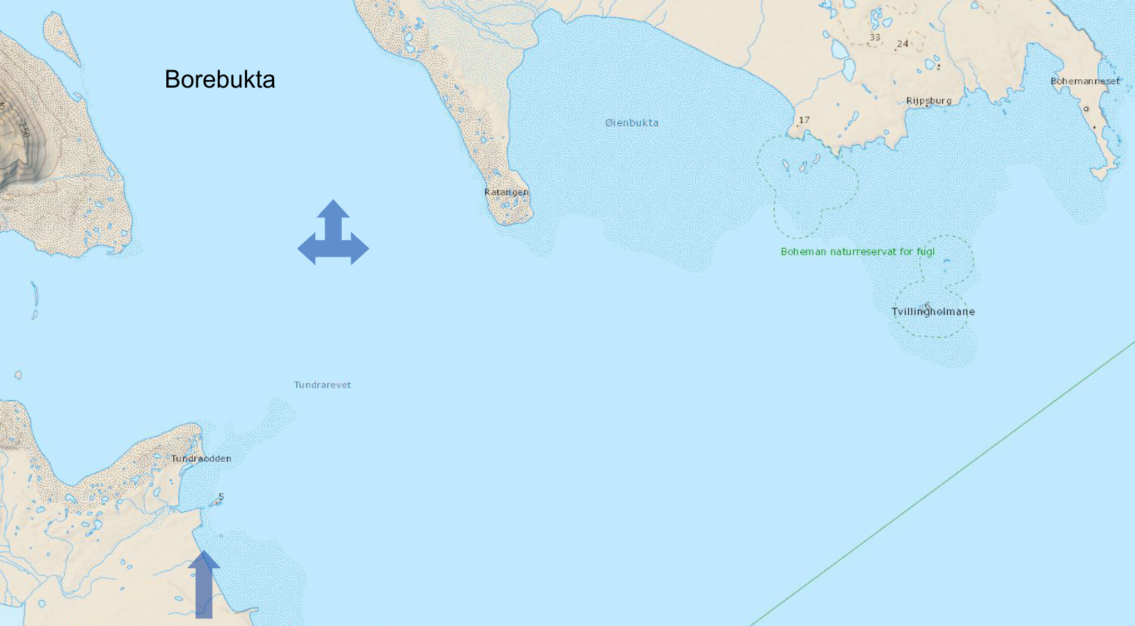
| 2022-08-25 | 14.00-11.00 | Borebukta | 78°22.445 | 14°17.839 | lander/bait/camera 50 m | plastic count | tidal flat sampling | seabed photo-profile 5.15, 30 m | coastal ponds | |
| 2022-08-26 | 14.30-24.00 | Eidembukta | 78°21.680 | 12°47.404 | lander/bait/camera 27 m | plastic count | tidal flat sampling | seabed photo-profile 5.15, 30 m | coastal ponds |
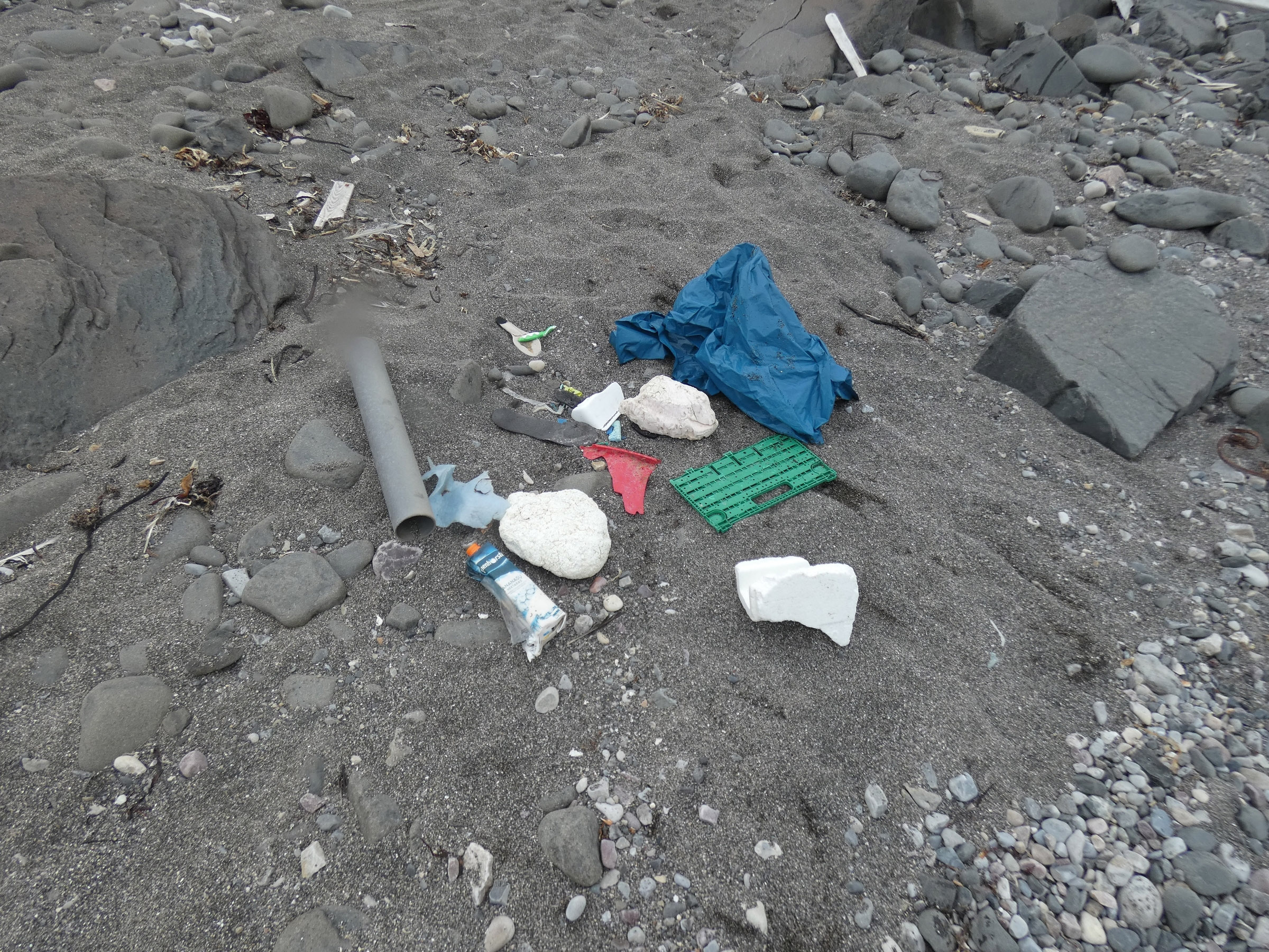
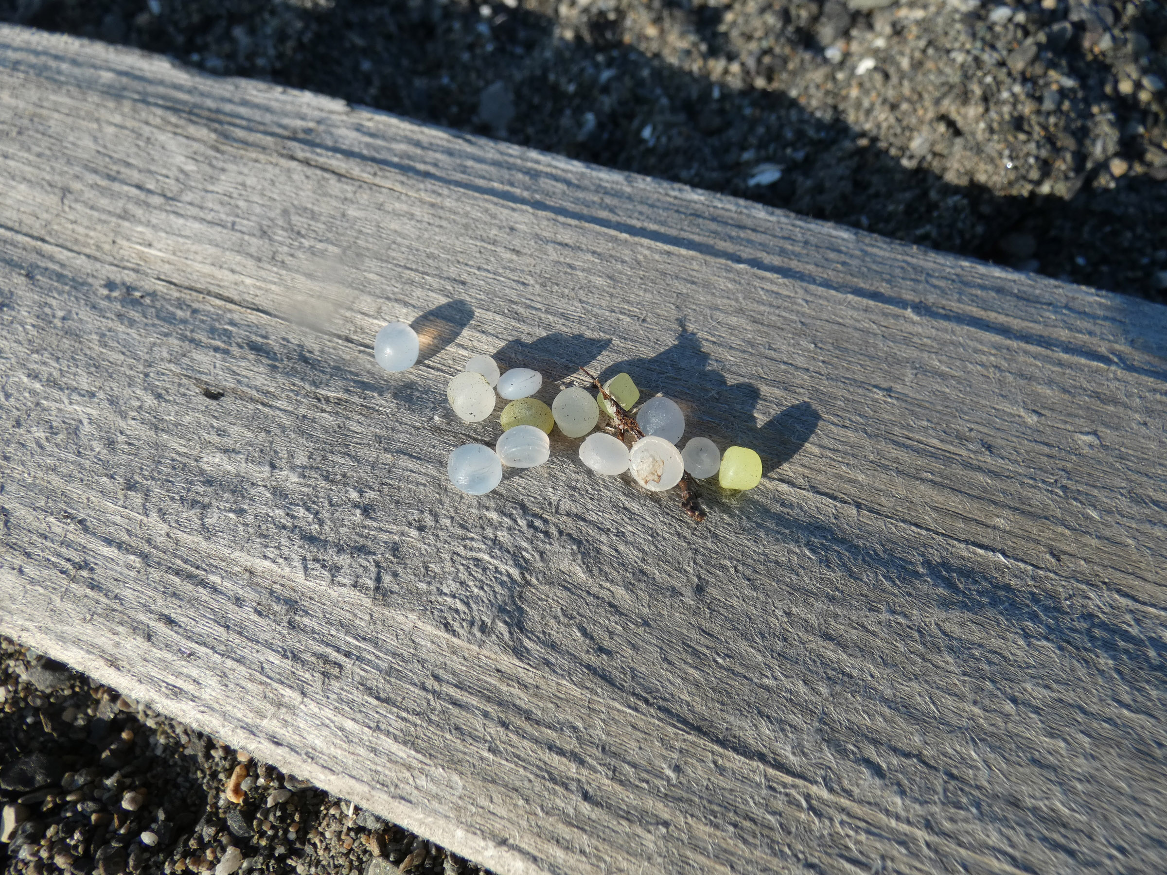
Plastic count
| date | time | place name | latitude | longitude | 100 m unit nr of items | 100 m unit nr of items | 100 m unit nr of items | photo |
| 2022-08-24 | 14.15-11.00 | Ekmanfjorden/Tolmodbukta | 78°39,799' | 14°50,948' | 2 | 2 | 3 | |
| 2022-08-25 | 14.00-11.00 | Borebukta/Tundraodden | 78°20,130' | 14°13,732' | 50 | 30 | 23 | |
| 2022-08-26 | 14.30-24.00 | Eidembukta | 78°22,151' | 12°45,534' | 15 | 15 | 30 |
Diary
|
23th August 2022, arrival to Longyearbyen, accommodation at UNIS guesthouse, partly on OCEANIA
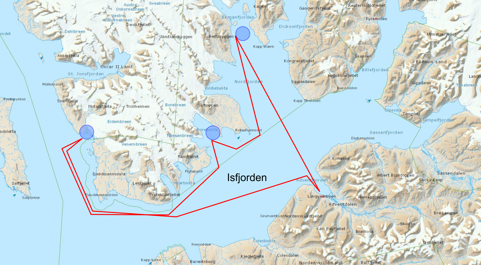
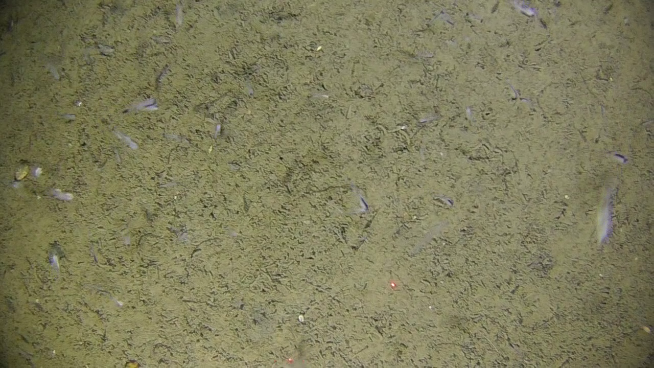
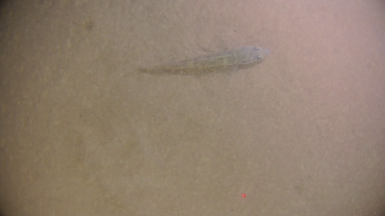
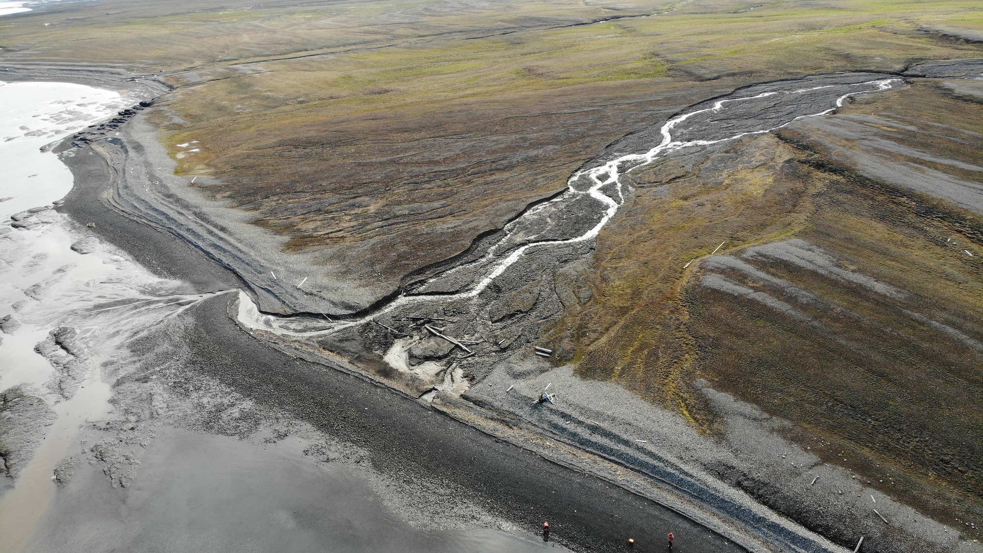
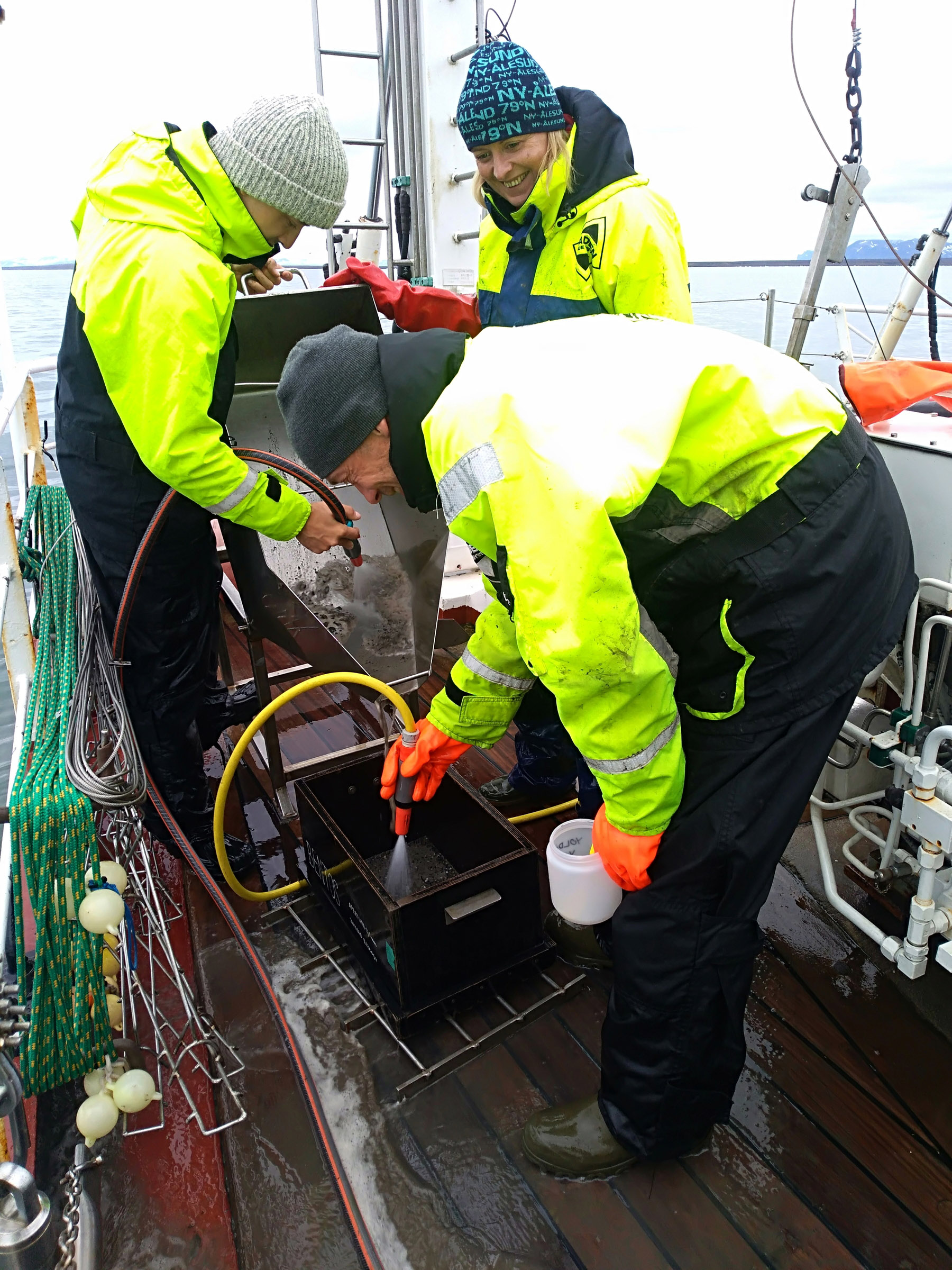
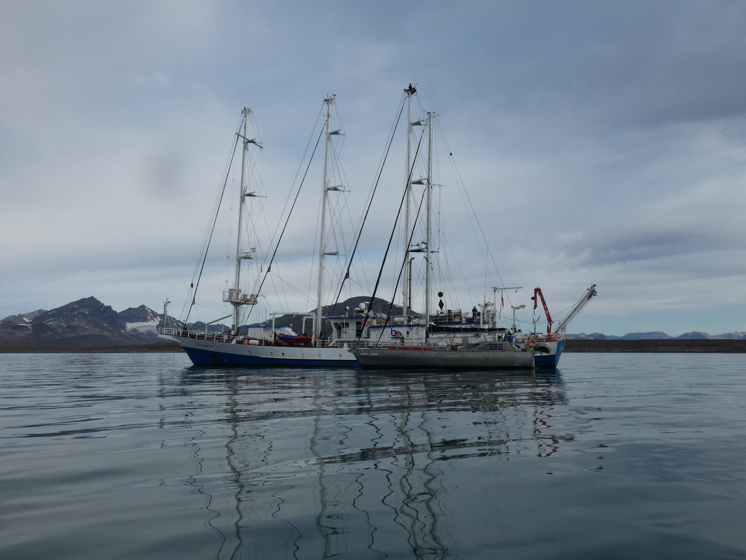
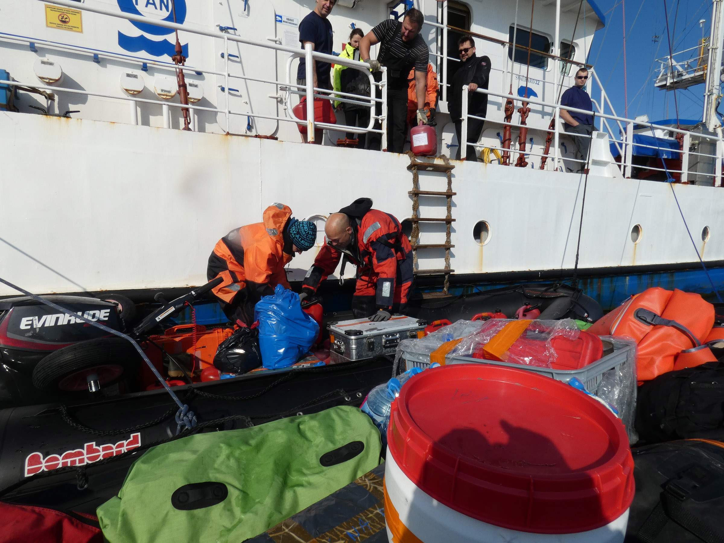
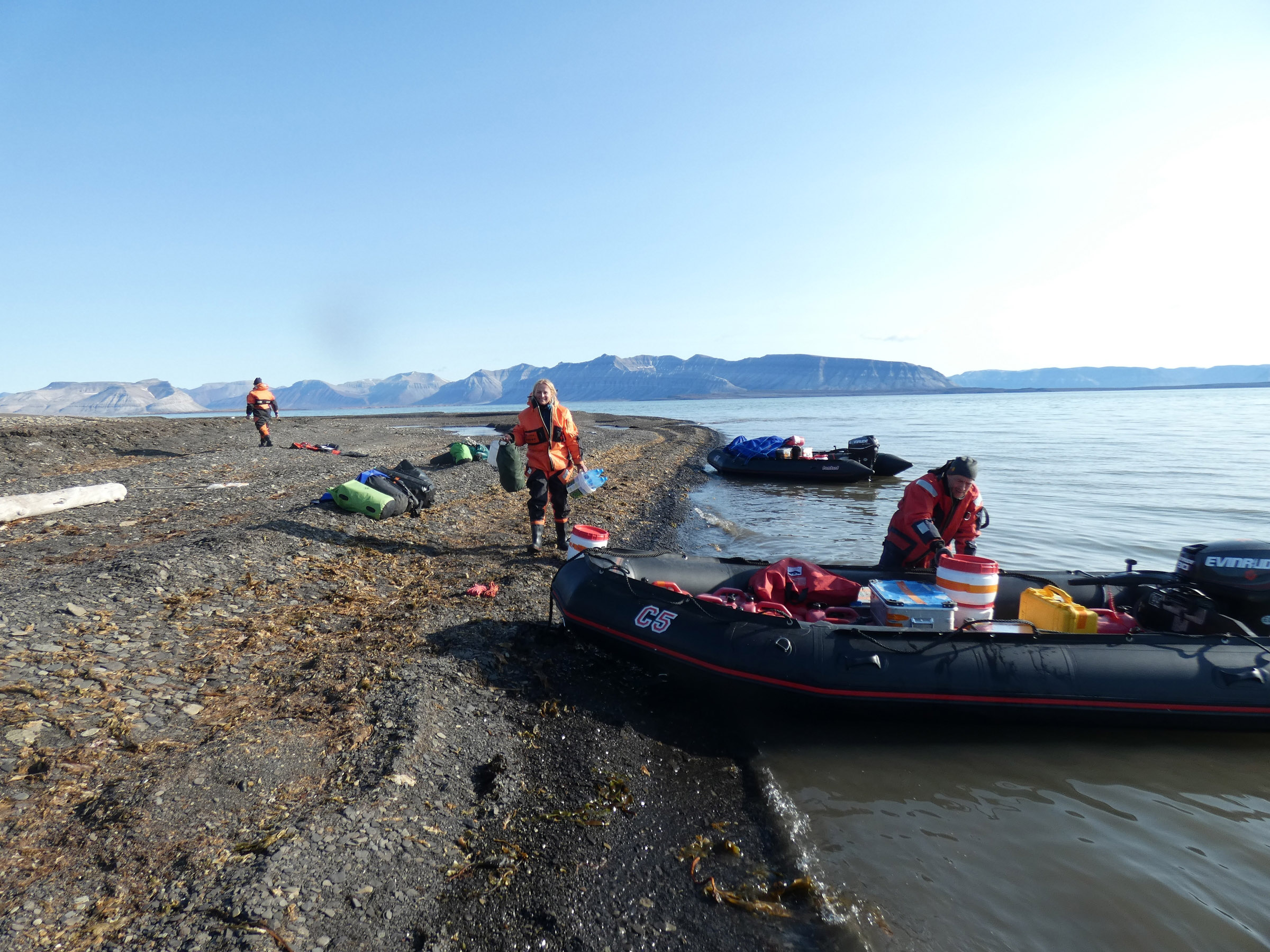
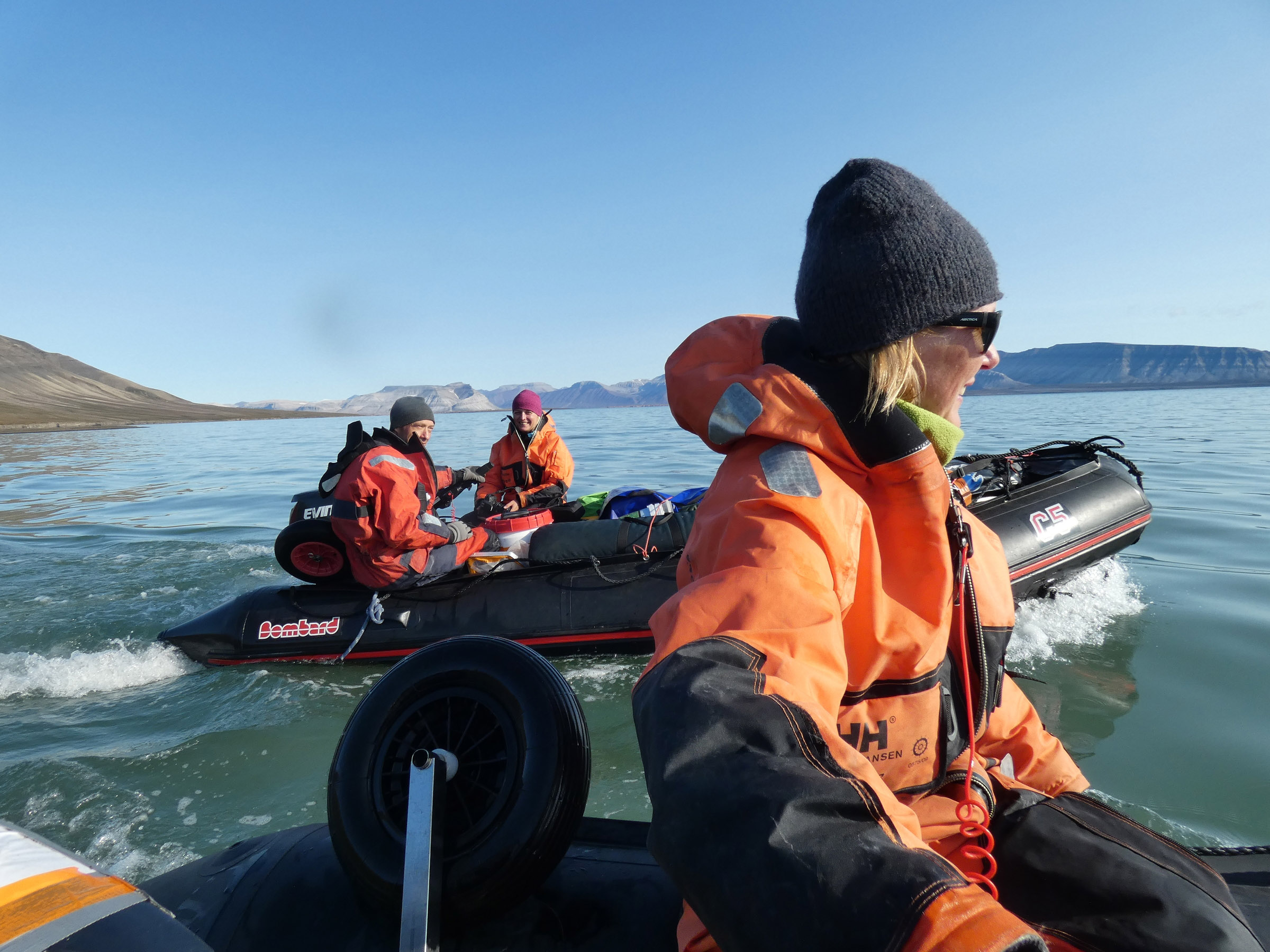
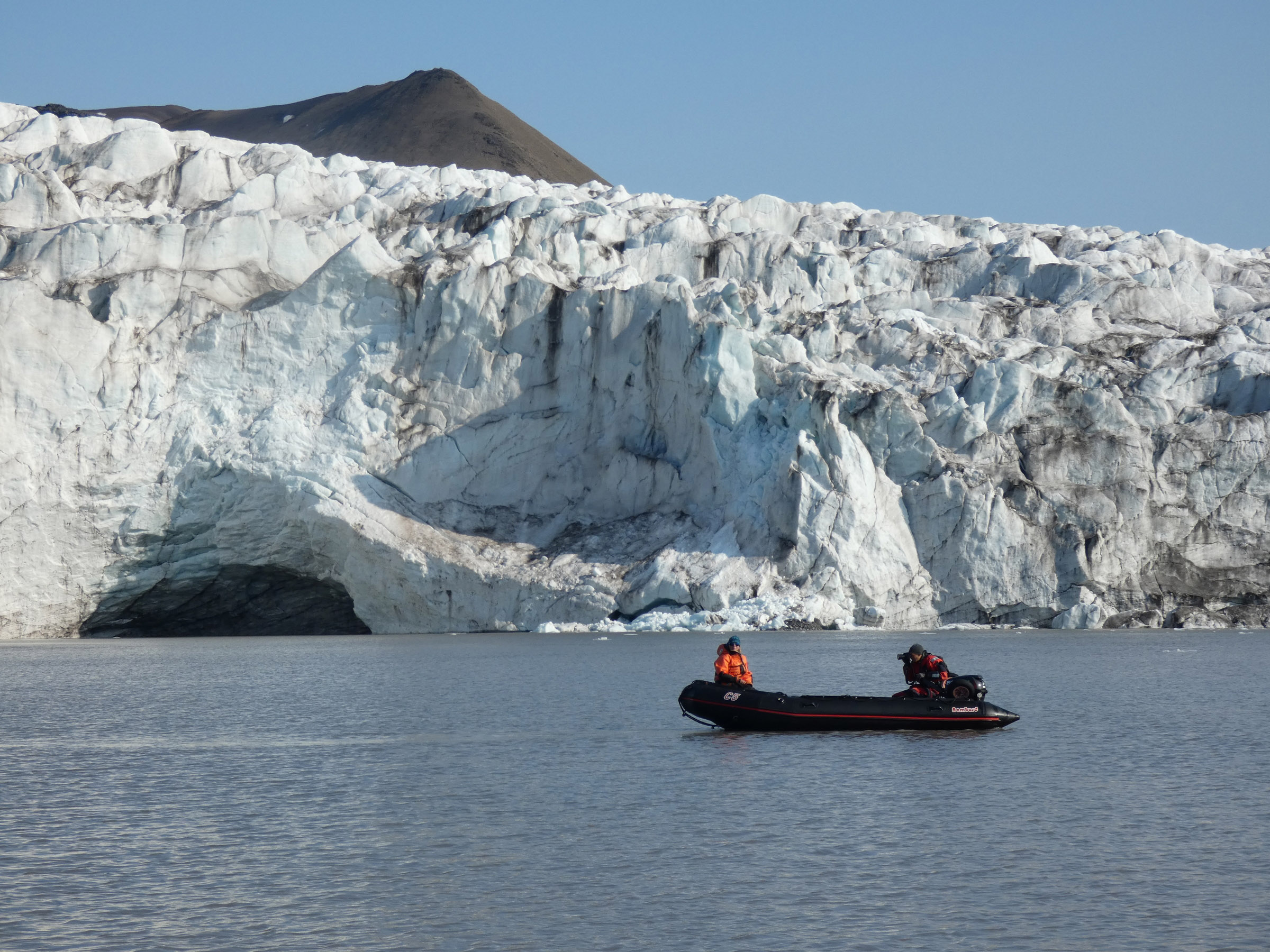
24th August, boarding to OCEANIA 08.00 Steaming to the NW corner of Isfjorden, on the way biooptical measurements. Anker on 35m depth at 14.00 in Ekmanfjorden. Deployment of lander with time laps cameras and fresh cod as bait. Land groups dedicated for fresh water ponds, tidal zone sampling, count of plastic and driftwood on the shore. Boat with CTD and drop camera to check the seabed coverage at 5, 15 and 30 m izobath. Work was completed before midnight, and samples have been marked and secured onboard. | ||
 Kajetan Deja prepares lander with time laps cameras for deployment |
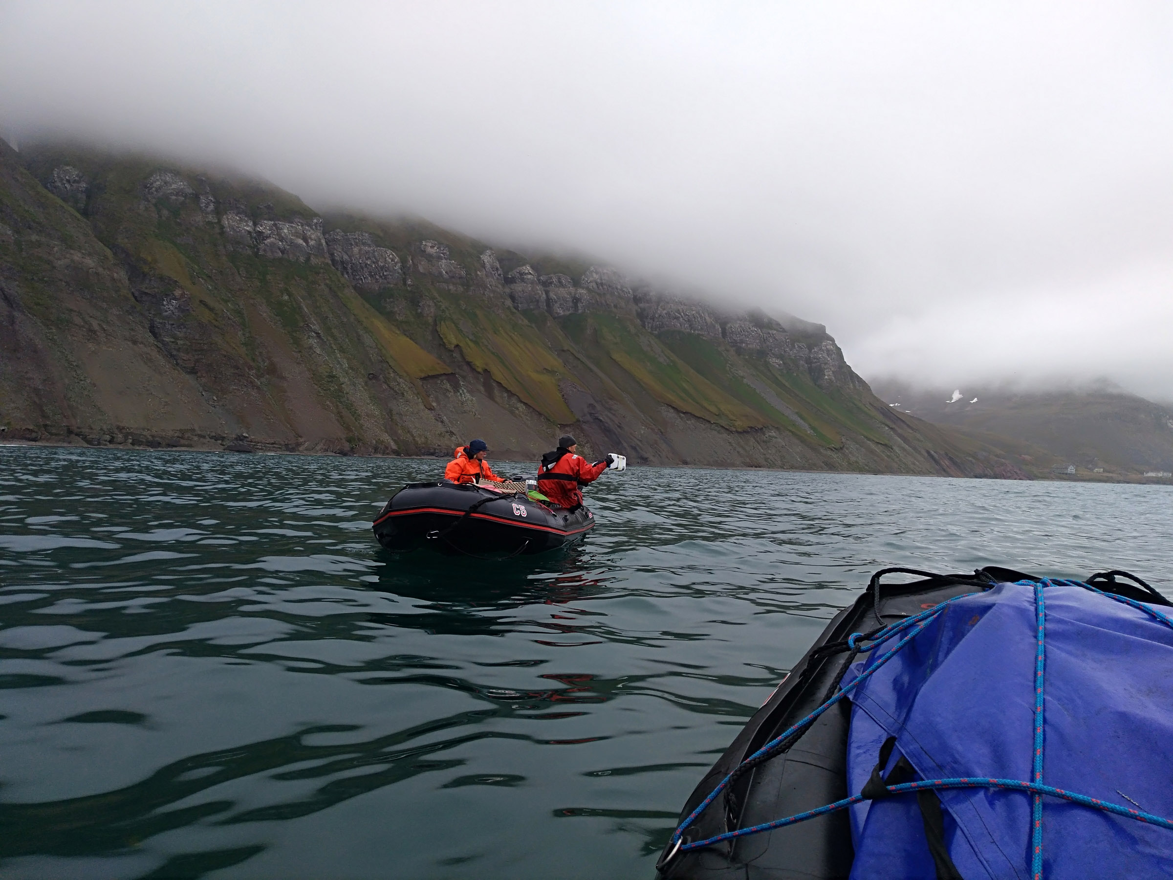
 Land groups leaving for field work |
 Place selected for tidal sampling |
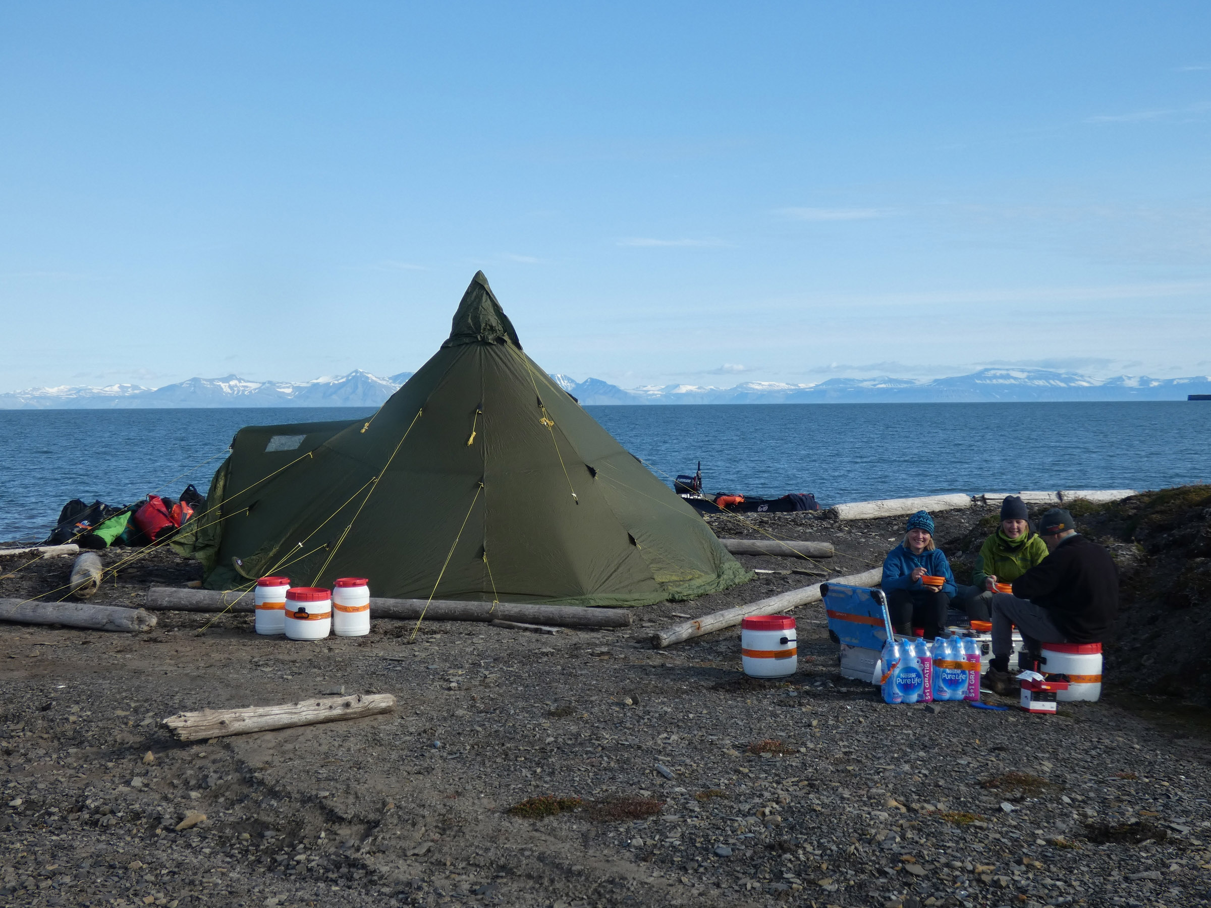
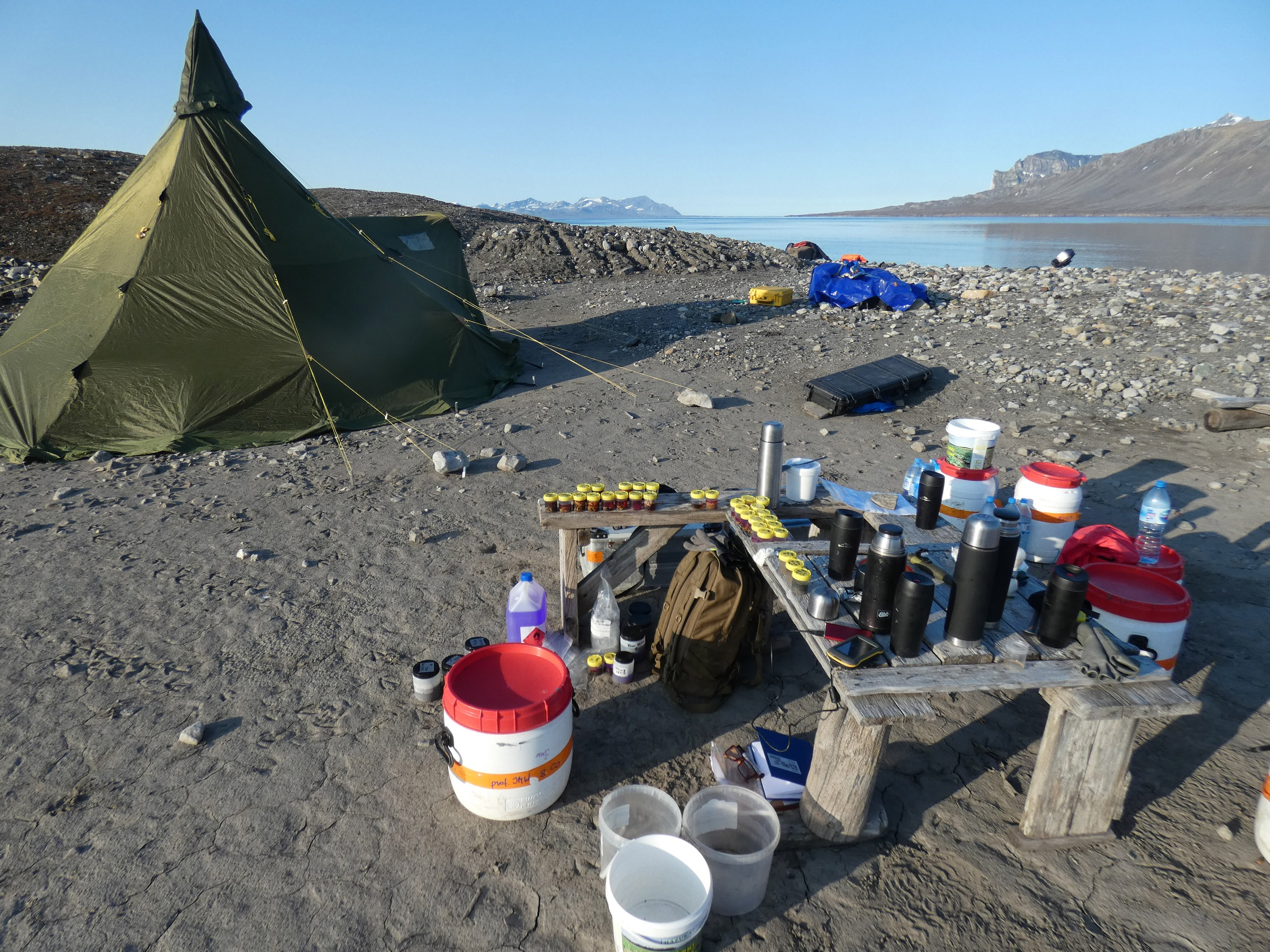
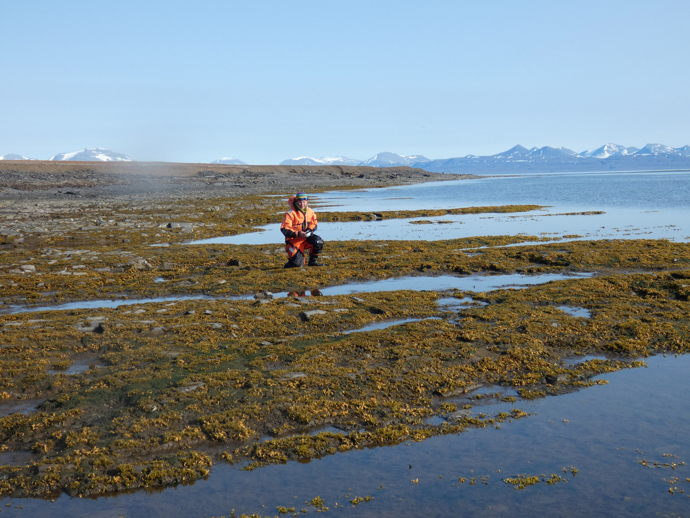
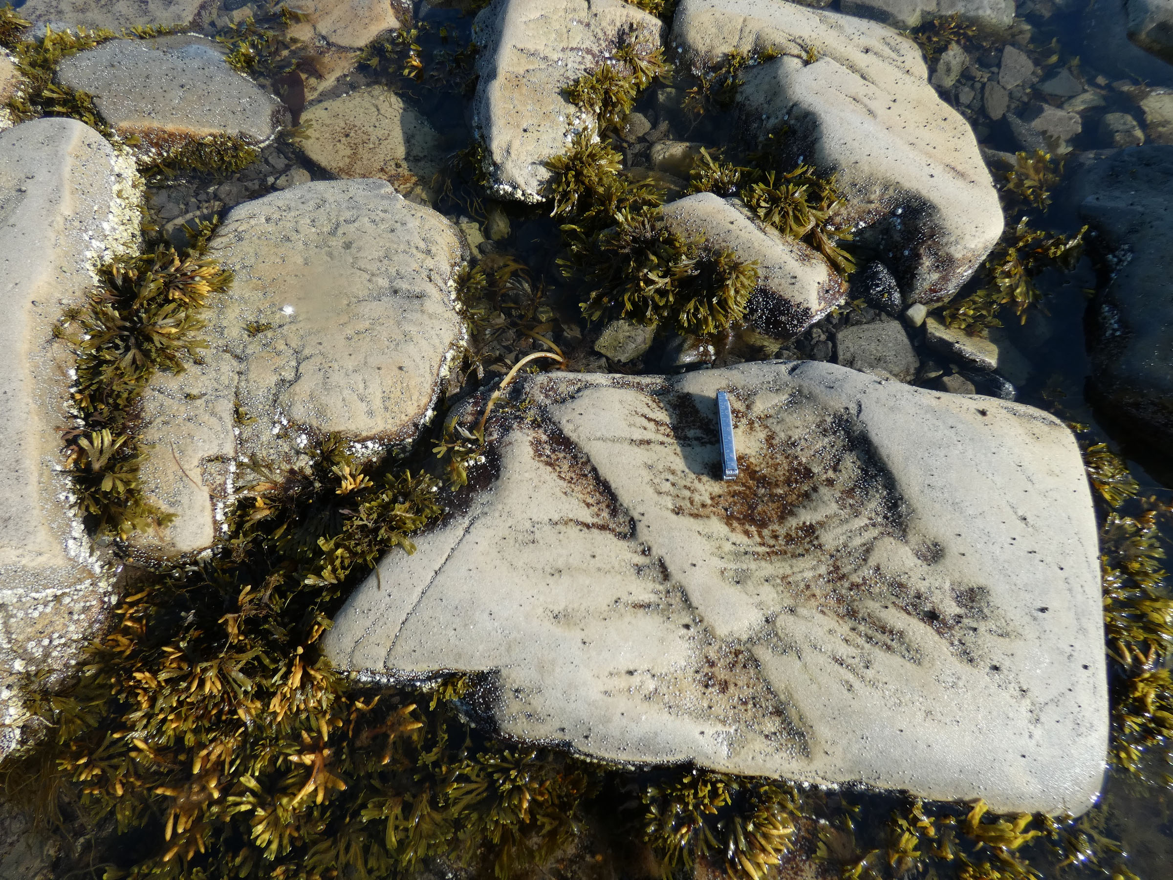
 Sampling in coastal freshwater ponds at Coraholmen |
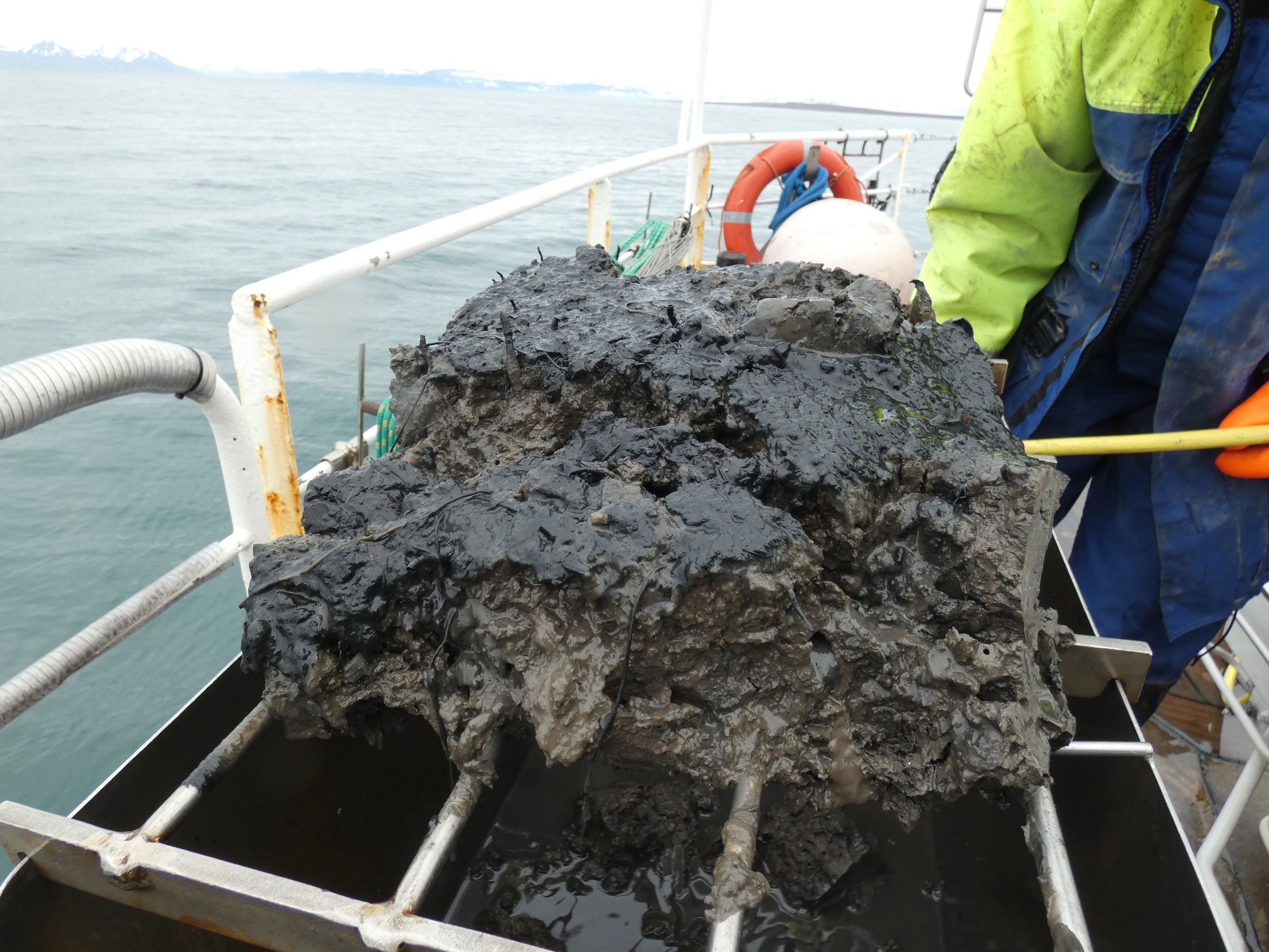
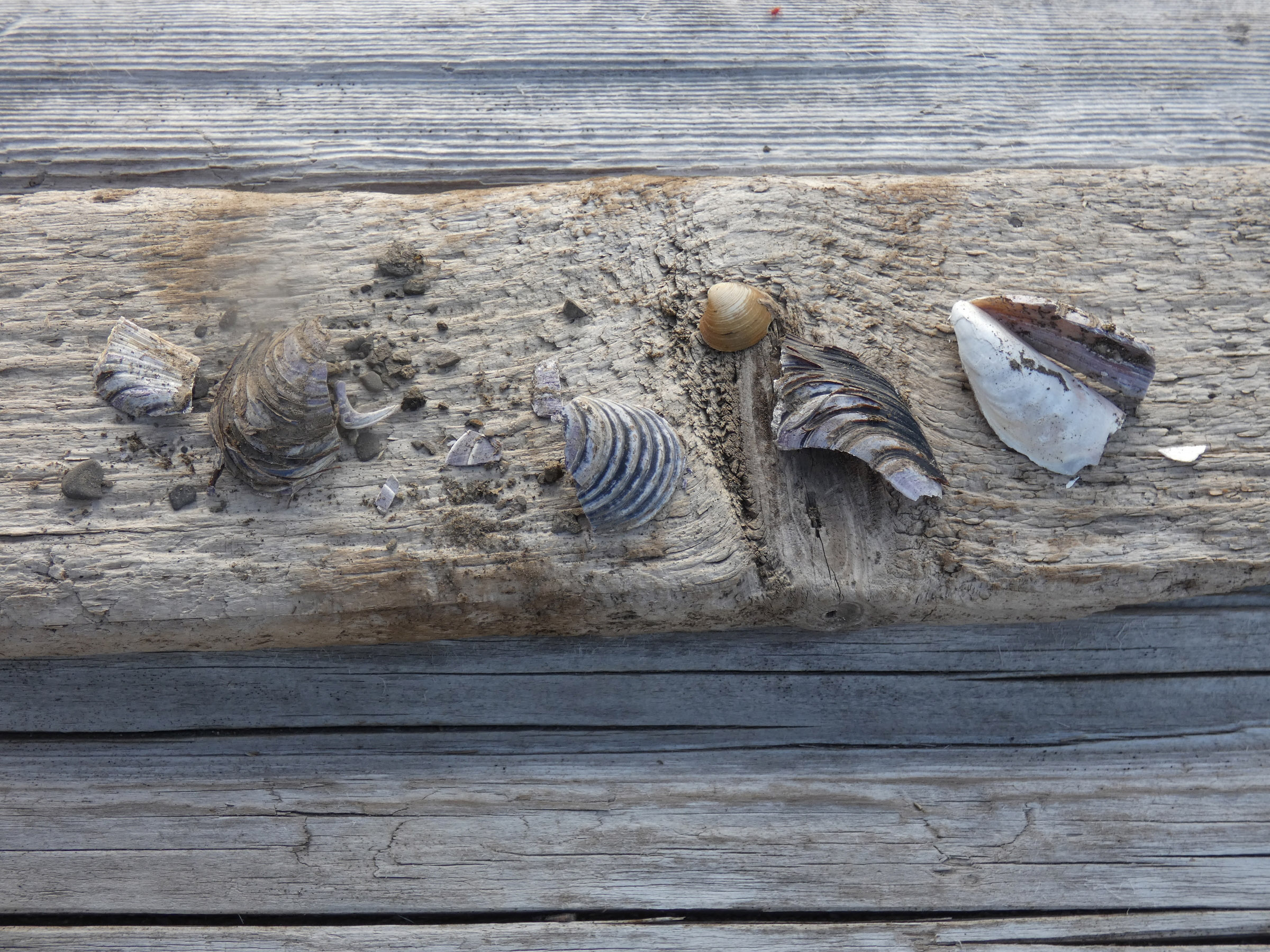
 Surprising rich calcium deposits formed by bivalves and calciferous algae during last climate optimum (7000 year ago) – now surfaced by glacier moraines erosion |
 Living thermophilic bivalve Mytilus edulis found in the littoral of Ekmanfjorden |
|
25th August 2022
09.00 Retrieval of lander with baited traps, numerous amphipods in the net (Lysianassidae – Anonyx and Onisimus). Steaming to Borebukta, with biooptical measurements on the way. Anker at Borebukta at 14.30 at 50 m depth, deployment of lander with cameras. Coastal groups depart for the field work. Large amount of driftwood and plastic debris found on the shore. Freshwater ponds with surprisingly high pH (above 8). Coastal work completed after midnight. | ||
 Coastal landscape at Borebukta |
 Land groups await the transportation back to the ship |
|
26th August 2022 Retreival of lander at 09.00 with surprising photos of three spider crabs (Hyas araneus) each with sea lilly (Heliometra glacialis) mounted on the carapace. Steaming to Eidembukta with biooptical work on the way. Numerous dolphins (white beaked dolphins, doglings) and minky whales. Anker at 13.00 in Eidembukta at 27 m depth. Deployment of land groups and arrangements with Lithuanian team working in the lagoon for their transport. Work completed and all equipment onboard before 23.00, extra precautions taken, as polar bear wasspotted near the Eidembukta lagoon – still in safe distance over 2 km. 23.00, extra precautions taken, as polar bear was spotted near the Eidembukta lagoon – still in safe distance over 2 km. |
 Epibenthic dredging for macrofauna photography |
 Joint field work with University of Klaipeda team – Tobia Politi from UK and Guillermo de Mendoza from our team to the ship |
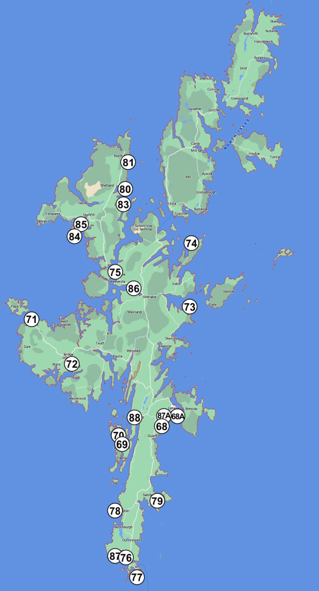
Shetland archipelago field work 2022
 |
| nr | date | station nr | place name | lat | long | coast type | exposure | nr of plots with plastic | nr of plastic objects in 10 of 1 m2 |
estimated weight class of plastic per 100 m2 |
plastic density class | photos |
| 01 | 11.07.22 | 68_A | Breiwick Rd | 60°08'966"N | 001°20'087 W | boulder | full | 50 | 8 | 1-10 kg | 1-10 | |
| 02 | 11.07.22 | 68 | S of Lerwick | 60°08'25,5" | 001°09'31,7" W | skjerra, boulder | sheltered | 60 | 6 | 0.1-1 kg | 1 to 10 | |
| 03 | 12.07.22 | 69 | W Burra Meal Beach | 60°06'086" | 001°19'777" W | sandy beach | full | 80 | 83 | 11-50 kg | 51 to 100 | |
| 04 | 12.07.22 | 70 | W of W Burra | 60°06'120" | 001°20'087 W | stony beach | exposed | 70 | 22 | 0.1-1 kg | 11 to 50 | |
| 05 | 12.07.22 | 71 | Sandness | 60°18'216 N | 001°30'578 W | stony beach | exposed | 40 | 11 | 0.1-1 kg | 11 to 50 | |
| 06 | 12.07.22 | 72 | Loch of Brouster | 60°14'637 N | 001°31'722 W | stony tidal flat | sheltered | 30 | 3 | 0.1-1 kg | 1 to 10 | |
| 07 | 13.07.22 | 73 | Kirkabister _ Neap | 60°14,637 N | 001°31,722 W | stony beach | exposed | 80 | 18 | 1-10 kg | 11 to 50 | |
| 08 | 13.07.22 | 74 | Lunna _ Outrabister | 60°26'342 | 001°04'666 W | stony beach | exposed | 90 | 15 | 1-10 kg | 11 to 50 | |
| 09 | 13.07.22 | 75 | Brae | 60°23'696 | 001°21'392 W | low gravel & stony beach | sheltered | 100 | 47 | 0.1-1 kg | 11 to 50 | |
| 10 | 14.07.22 | 76 | Laevenwick beach | 59°58,515 N | 01°15'549 W | sandy beach | semi exposed | 30 | 13 | 0.1-1 kg | 11 to 50 | |
| 11 | 14.07.22 | 77 | Sumburgh beach | 59°52'539 N | 01°17'984 W | sandy beach | exposed | 60 | 6 | 0.1-1 kg | 1 to 10 | |
| 12 | 14.07.22 | 78 | St. Ninian tombola | 59°58'229 N | 01°19'916 W | sandy beach | semi exposed | 50 | 16 | 11-50 kg | 11 to 50 | |
| 13 | 14.07.22 | 79 | Sandvick - Mousa ferry | 60°00'412 N | 01°13'326 W | stony beach | semi exposed | 70 | 8 | 0.1-1 kg | 1 to 10 | |
| 14 | 15.07.22 | 80 | Colla Firth Ferrry | 60°00,412 N | 01°13,326 W | stony beach | semi exposed | 90 | 17 | 1-10 kg | 11 to 50 | |
| 15 | 15.07.22 | 81 | North Roe | 60°35,151 N | 01°19,819 W | stony beach | exposed | 10 | 26 | 1-10 kg | 11 to 50 | |
| 16 | 15.07.22 | 83 | Ollaberry | 60°30,430 N | 01°19,612 W | stony beach | exposed | 60 | 8 | 0.1-1 kg | 1 to 10 | |
| 17 | 15.07.22 | 84 | Hillswick | 60°28,434 N | 01°29,367 W | stony beach | semi exposed | 70 | 16 | 0.1-1 kg | 11 to 50 | |
| 18 | 15.07.22 | 85 | Ness of Hillswick | 60°27,729 N | 01°29,403 W | stony & rocky beach | semi exposed | 50 | 5 | 0.1-1 kg | 1 to 10 | |
| 19 | 16.07.22 | 86 | Voe of Sound | 60°08,356 N | 01°10,312 W | sandy beach | sheltered | 60 | 9 | 11-50 kg | 1 to 10 | |
| 20 | 16.07.22 | 87_A | Lerwick Bains beach | 60°09' N | 01°08' W | pocket sandy beach | sheltered | 20 | 3 | 0.1-1 kg | 1 to 10 | |
| 21 | 17.07.22 | 87 | Sumburgh airport beach | 59°52,337 N | 01°16,895 W | steep sandy beach | exposed | 20 | 4 | 0.1-1 kg | 1 to 10 | |
| 22 | 12.07.22 | 88 | Scalloway harbor beach | 60°08' N | 01°16' W | flat gravel beach | sheltered | 100 | 400 | 1-10 kg | over 100 |
Full work data (XLSX)
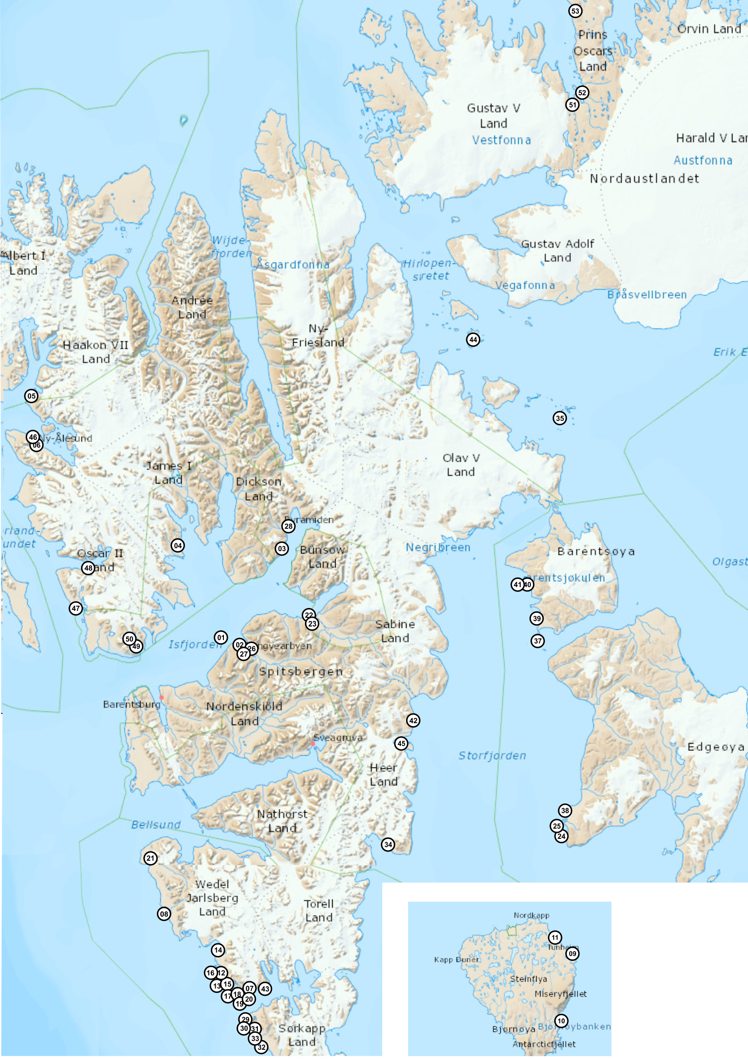
Field work 2021 on the coast - IO PAN, maps of points
|
Field work 2021 on the coast - IO PAN, data table
| nr | date | place name | lat | long | G. oceanicus | G. setosus | G. oceanicus % | G. setosus % | collected by | photo |
| 01 | 2021.08.19 | Isfjorden Grumant | 78°16.35251 | 15°05.4776 | 11 | 24 | 31 | 69 | M.Włodarska | |
| 02 | 2021.08.18 | Isfjorden Longyearbyen | 78°13'24,6 | 15°40'07,3 | 6 | 16 | 27 | 73 | M.Włodarska | |
| 03 | 2021.08.16 | Isfjorden Pyramiden | 78.53.0518' | 10.42.1104' | 20 | 25 | 44 | 56 | M.Włodarska | |
| 04 | 2021.08.15 | Isfjorden Lundbohmfjellet_Sveasletta | 78°35.224 | 14°31.603 | 3 | 40 | 7 | 93 | M.Włodarska | |
| 05 | 2021.08.06 | NW Spitsbergen Krossfjorden | 79 08.9893 | 011 50.3734 | 0 | 38 | 0 | 100 | M.Włodarska | |
| 06 | 2021.08.05 | NW Spitsbergen Kongsfjorden | 78 55.6587 | 011 55.8441 | 0 | 12 | 0 | 100 | M.Włodarska | |
| 07 | 2021.07.28 | Sorkapp Hornsund 1 | 76 59.667 | 015 32.983 | 26 | 8 | 76 | 24 | M.Włodarska | |
| 08 | 2021.07.30 | Sorkapp Hornsund 2 | 77 15.5866 | 014 18.2066 | 68 | 10 | 87 | 13 | M.Włodarska | |
| 09 | 2021.07.18 | Bjørnøya Nordenskjold | 74 27.570 | 19 16.073 | 0 | 13 | 0 | 100 | M.Włodarska | |
| 10 | 2021.07.18 | Bjørnøya Russehamna | 74 23.258 | 19 10.350 | 0 | 71 | 0 | 100 | M.Włodarska | |
| 11 | 2021.07.16 | Bjørnøya Austerwag | 74 28.990 | 19 11.396 | 0 | 62 | 0 | 100 | M.Włodarska | |
| 12 | 2021.05.12 | Sorkapp Hytt05 | 77.04177601262 | 15.15302097424 | 57 | 0 | 100 | 0 | T.Jankowski | |
| 13 | 2021.05.12 | Sorkapp Hytt03 | 77.02742602676 | 15.1687510404 | 26 | 32 | 45 | 55 | T.Jankowski | |
| 14 | 2021.04.29 | Sorkapp Tor01 | 77.15116797946 | 15.12677698396 | 14 | 19 | 42 | 58 | T.Jankowski | |
| 15 | 2021.04.29 | Sorkapp Hytt01 | 77.05422900617 | 15.13337002135 | 63 | 2 | 97 | 3 | T.Jankowski | |
| 16 | 2021.04.29 | Sorkapp Hytt04 | 77.05029495991 | 15.14049103483 | 74 | 0 | 100 | 0 | T.Jankowski | |
| 17 | 2021.04.28 | Sorkapp Hor04 | 77.00530802831 | 15.34268600866 | 38 | 4 | 90 | 10 | T.Jankowski | |
| 18 | 2021.04.28 | Sorkapp Hor02 | 77.0002430118 | 15.47343900427 | 48 | 13 | 79 | 21 | T.Jankowski | |
| 19 | 2021.04.28 | Sorkapp Hor01 | 76.995957009495 | 15.54123200476 | 28 | 8 | 78 | 22 | T.Jankowski | |
| 20 | 2021.04.28 | Sorkapp Hor03 | 77.00037796050 | 15.43342396616 | 60 | 16 | 79 | 21 | T.Jankowski | |
| 21 | 2021.04.26 | Sorkapp Oun4 | 77.47700901702 | 14.02798499912 | 47 | 12 | 80 | 20 | T.Jankowski | |
| 22 | 2020.08.03 | Isfjorden Sassendalen1 | 78°19'59.35"N | 16°39'9.04"E | 26 | 37 | 41 | 59 | K.Deja | |
| 23 | 2020.08.03 | Isfjorden Sassendalen2 | 78°19'59.35"N | 16°39'9.04"E | 22 | 24 | 48 | 52 | K.Deja | |
| 24 | 2020.07.27 | SESNP Edgeoya1/51 | 77°32'4.79"N | 20°51'29.26"E | 0 | 51 | 0 | 100 | K.Deja | |
| 25 | 2020.07.27 | SESNP Edgeoya2/52 | 77°32'18.76"N | 20°51'3.30"E | 0 | 43 | 0 | 100 | K.Deja | |
| 26 | 2017.09.20 | Isfjorden Lyr_tidal_harbour | 78°13'31.8 | 15°37'59.2 | 0 | 25 | 0 | 100 | J.M.W. | |
| 27 | 2017.09.18 | Isfjorden Longyearbyen LOFF | 78°13'24.6 | 15°40'07.3 | 1 | 185 | 1 | 99 | J.M.W. | |
| 28 | 2017.08.13 | Isfjorden Pyramiden | 78.53.0518' | 10.42.1104' | 0 | 67 | 0 | 100 | J.M.W. | |
| 29 | 2021.07.28 | Sorkapp WG1 N of Palffyodden | N76°53.628' | E15°30.789' | 14 | 0 | 100 | 0 | A.Nawrot | |
| 30 | 2021.07.28 | Sorkapp WG2 Palffyodden | N76°53.442' | E15°30.004' | 17 | 0 | 100 | 0 | A.Nawrot | |
| 31 | 22021.07.28 | Sorkapp WG3 Palffyodden | N76°53.290' | E15°29.671' | 18 | 0 | 100 | 0 | A.Nawrot | |
| 32 | 2021.07.28 | Sorkapp WG4 Breinesflya | N76°49.936' | E15°43.046' | 23 | 0 | 100 | 0 | A.Nawrot | |
| 33 | 2021.07.29 | Sorkapp WG5 Bjornskaubukta | N76°50.932' | E15°37.803' | 37 | 0 | 100 | 0 | A.Nawrot | |
| 34 | 2021.06.26 | SESNP Kvalvagen-Boltodden | 77°30.862 | 17°56.327 | 0 | 26 | 0 | 100 | J.Soreide | |
| 35 | 2021.06.28 | SESNP Kiepertoya-Barentsoya | 78°58.712 | 21°43.228 | 0 | 29 | 0 | 100 | J.Soreide | |
| 36 | 2021.06.25 | SSNP Gnalodden-Hornsund | 77°00.885 | 15°52.026 | 6 | 36 | 17 | 83 | J.Soreide | |
| 37 | 2020.09.16 | SESNP Ureinbukta-Barentsoya | 78°12.178 | 20°41.528 | 0 | 36 | 0 | 100 | J.Soreide | |
| 38 | 2020.09.15 | SESNP Martinodden, Edgeoya | 77°35.414 | 20°55.485 | 0 | 32 | 0 | 100 | J.Soreide | |
| 39 | 2020.09.17 | SESNP Anderssonbukta, Barentsoya | 78°16.877 | 20°45.576 | 0 | 3 | 0 | 100 | J.Soreide | |
| 40 | 2020.09.17 | SESNP Gauldalen A Barentsoya | 78°24.399 | 20°37.444 | 0 | 43 | 0 | 100 | J.Soreide | |
| 41 | 2020.09.17 | SESNP Gauldalen B Barentsoya | 78°24.399 | 20°37.444 | 0 | 22 | 0 | 100 | J.Soreide | |
| 42 | 2021.06.27 | SESNP Kapp Dufferin Storfjorden | 77°57.601 | 18°28.463 | 0 | 35 | 0 | 100 | J.Soreide | |
| 43 | 2021.06.25 | SSNP Gnalodden-Hornsund | 77°00.885 | 15°52.026 | 4 | 24 | 14 | 86 | J.Soreide | |
| 44 | 2021.06.29 | SESNP Von Otteroya | 79°15.764 | 19°59.082 | 0 | 5 | 0 | 100 | J.Soreide | |
| 45 | 2020.09.19 | SSNP Inglefjeldbukta - laggon | 77°52.166 | 18°13.150 | 0 | 2 | 0 | 100 | J.Soreide | |
| 46 | 2021.08.08 | Kongsfjorden K_1 | 78.927645° | 11.939735° | 2 | 20 | 10 | 90 | J.Legeżyńska | |
| 47 | 2021.07.28 | Isfjorden, Eidembukta, EID_1n | 78.3672056° | 12.7494694° | 26 | 6 | 81 | 19 | S. Olenin | |
| 48 | 2021.07.26 | Isfjorden, StJohnsfjord, StJ1 | 78.5053306° | 12.9301222° | 0 | 49 | 0 | 100 | S. Olenin | |
| 49 | 2021.07.30 | Tryghamna_1 | 78.2450056° | 13.7688194° | 10 | 24 | 29 | 71 | S. Olenin | |
| 50 | 2021.07.30 | Tryghamna_4 | 78.2596194° | 13.7143667° | 9 | 12 | 43 | 57 | S. Olenin | |
| 51 | 2021.09.07 | Nordaustalandet Rijpfjorden beach 1 | 80°00.258 | 22°18.863 | 0 | 23 | 0 | 100 | J. Soreide | |
| 52 | 2021.09.08 | Nordaustalandet Rijpfjorden beach 2 | 80°03.55 | 22°30.513 | 0 | 15 | 0 | 100 | J. Soreide | |
| 53 | 2021.09.10 | Nordaustalandet Rijpfjorden beach 3 | 80°17.049 | 22°33.161 | 0 | 21 | 0 | 100 | J. Soreide |
Sampling summer 2020 from OCEANIA - stations map
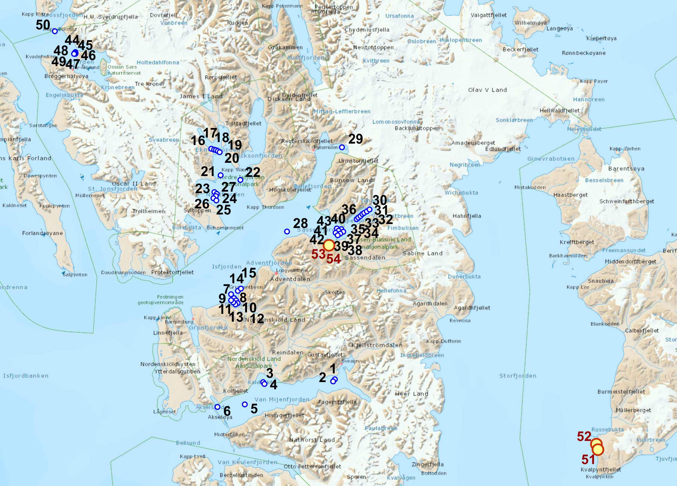
Sampling summer 2020 from OCEANIA - data collector Kajetan Deja
| station nr |
station name |
activity | date | hour (UTC) |
lat (start) | long (start) | depth | photo |
| 1 | VM4 | 1x VV, 1x BOX, 1x Niemisto, CTD, 1x dropcamera | 19.07.2020 | 08.20 | 77°50.328’N | 016°37.844’E | 73 |


|
| 2 | VM5 | 1x VV, 1x BOX, 1x Niemisto, CTD, 1x dropcamera | 19.07.2020 | 09:24 | 77°49.954’N | 016°36.117’E | 74 |


|
| 3 | VM4A | 1x dropcamera | 19.07.2020 | 12:40 | 77°49.987’N | 015°25.112’E | 64 |


|
| 4 | VM4A' | 1x dropcamera | 19.07.2020 | 13:20 | 77°49.744’N | 015°26.214’E | 77 |


|
| 5 | VM Bref | 1x dropcamera | 19.07.2020 | 14:37 | 77°45.312’N | 015°07.804’E | 107 |


|
| 6 | VMB2 | 1x dropcamera, 1x VV | 19.07.2020 | 16:43 | 77°44.762’N | 014°40.440’E | 77 |


|
| 7 | Colesbukta 1 | 1x dropcamera | 20.07.2020 | 8:31 | 78°08.372’N | 014°53.367’E | 100 |


|
| 8 | Colesbukta 2 | 1x dropcamera | 20.07.2020 | 9:34 | 78°07.924’N | 014°56.008’E | 60 |


|
| 9 | Colesbukta 3 | 1x dropcamera | 20.07.2020 | 10:01 | 78°07.613’N | 014°52.762’E | 47 |


|
| 10 | Colesbukta 4 | 1x dropcamera | 20.07.2020 | 10:56 | 78°07.484’N | 014°57.281’E | 39 |


|
| 11 | Colesbukta 5 | 1x dropcamera | 20.07.2020 | 11:34 | 78°07.257’N | 014°54.611’E | 41 |


|
| 12 | Colesbukta 6 | 1x dropcamera | 20.07.2020 | 12:00 | 78°06.750’N | 014°58.661’E | 25 |


|
| 13 | Colesbukta 7 | 1x dropcamera | 20.07.2020 | 12:34 | 78°06.581’N | 014°56.126’E | 26 |


|
| 14 | Isf AZ 1 | 1x dropcamera | 20.07.2020 | 13:59 | 78°09.670’N | 014°59.530’E | 104 |


|
| 15 | Isf AZ 1' | 1x dropcamera | 20.07.2020 | 14:16 | 78°09.985’N | 015°02.685’E | 45 |


|
| 16 | EK 1 | 1x VV, 1x BOX, 1x Niemisto, CTD, 1x dropcamera | 21.07.2020 | 6:03 | 78°40.154’N | 014°29.118’E | 50 |


|
| 17 | EK 2 | 1x VV, 1x BOX, 1x Niemisto, CTD, 1x dropcamera | 21.07.2020 | 7:28 | 78°39.997’N | 014°32.230’E | 48 |


|
| 18 | EK 3 | 1x VV, 1x BOX, 1x Niemisto, CTD, 1x dropcamera | 21.07.2020 | 8:25 | 78°39.885’N | 014°34.777’E | 36 |


|
| 19 | EK 4 | 1x VV, 1x BOX, 1x Niemisto, CTD, 1x dropcamera | 21.07.2020 | 8:59 | 78°39.663’N | 014°36.948’E | 42 |


|
| 20 | EK 5 | 1x VV, 1x BOX, 1x Niemisto, CTD, 1x dropcamera | 21.07.2020 | 10:32 | 78°39.471’N | 014°38.766’E | 52 |


|
| 21 | Isf AZ 3 | CTD, 1x dropcamera | 21.07.2020 | 13:27 | 78°34.109’N | 014°40.880’E | 107 |


|
| 22 | Isf AZ 4 | CTD, 1x dropcamera | 21.07.2020 | 14:37 | 78°32.977’N | 015°02.531’E | 109 |

|
| 23 | YOL 3 | 2x Niemisto, 1x dropcamera, CTD | 21.07.2020 | 16:49 | 78°30.485’N | 014°34.954’E | 60 |


|
| 24 | YOL 2 | 2x Niemisto, 1x dropcamera, CTD | 21.07.2020 | 18:07 | 78°29.667’N | 014°36.775’E | 71 |


|
| 25 | YOL 1 | 2x Niemisto, 1x dropcamera, CTD | 21.07.2020 | 19:20 | 78°28.753’N | 014°37.442’E | 69 |


|
| 26 | YOL 0 | 1x dropcamera | 21.07.2020 | 20:19 | 78°29.239’N | 014°34.305’E | 39 |


|
| 27 | YOL -1 | 1x dropcamera | 21.07.2020 | 20:37 | 78°30.131’N | 014°37.829’E | 84 |


|
| 28 | Isf AZ2 | 1x dropcamera | 21.07.2020 | 23:10 | 78°22.033’N | 015°50.397’E | 171 |
|
| 29 | BAB' | 1x dropcamera | 22.07.2020 | 09:05 | 78°39.825’N | 016°51.277’E | 89 |


|
| 30 | Temp 1 | 1x dropcamera | 24.07.2020 | 01:43 | 78°26.249’N | 017°17.583’E | 45 |


|
| 31 | Temp 2 | 1x dropcamera | 24.07.2020 | 02:30 | 78°25.889’N | 017°14.788’E | 36 |

|
| 32 | Temp 3 | 1x dropcamera | 24.07.2020 | 03:16 | 78°25.599’N | 017°11.948’E | 29 |


|
| 33 | Temp 4 | 1x dropcamera | 24.07.2020 | 03:37 | 78°25.350’N | 017°10.054’E | 45 |


|
| 34 | Temp 5 | 1x dropcamera | 24.07.2020 | 04:30 | 78°24.962’N | 017°08.004’E | 73 |


|
| 35 | Temp 6 | 1x dropcamera | 24.07.2020 | 05:18 | 78°24.639’N | 017°05.753’E | 72 |


|
| 36 | Temp 7 | 1x dropcamera | 24.07.2020 | 06:06 | 78°24.350’N | 017°03.922’E | 86 |


|
| 37 | Sassen 1 | 1x dropcamera | 24.07.2020 | 07:22 | 78°21.709’N | 016°52.026’E | 98 |


|
| 38 | Sassen 2 | 1x dropcamera | 24.07.2020 | 08:18 | 78°21.319’N | 016°48.940’E | 51 |


|
| 39 | Sassen 3 | 1x dropcamera | 24.07.2020 | 10:46 | 78°21.004’N | 016°46.245’E | 47 |


|
| 40 | Sassen 4 | 1x dropcamera | 24.07.2020 | 11:43 | 78°22.257’N | 016°50.142’E | 100 |


|
| 41 | Sassen 5 | 1x dropcamera | 25.07.2020 | 00:34 | 78°21.928’N | 016°47.308’E | 97 |


|
| 42 | Sassen 6 | 1x dropcamera | 25.07.2020 | 01:25 | 78°21.550’N | 016°44.172’E | 76 |


|
| 43 | Sassen 7 | 1x dropcamera | 25.07.2020 | 02:19 | 78°22.432’N | 016°45.625’E | 92 |


|
| 44 | Kblues 6 | 1x dropcamera | 08.08.2020 | 12:57 | 78°59.600’N | 011°57.200’E | 51 |


|
| 45 | Kblues 4 | 1x dropcamera | 08.08.2020 | 13:26 | 78°59.463’N | 011°57.293’E | 111 |


|
| 46 | Kblues 5 | 1x dropcamera | 08.08.2020 | 13:59 | 78°59.303’N | 011°57.545’E | 160 |


|
| 47 | Kblues 7 | 1x dropcamera | 08.08.2020 | 14:41 | 78°59.242’N | 011°57.007’E | 210 |


|
| 48 | Kblues 3 | 1x dropcamera | 08.08.2020 | 15:23 | 78°59.416’N | 011°56.598’E | 183 |


|
| 49 | Kblues 9 | 1x dropcamera | 08.08.2020 | 16:22 | 78°59.236’N | 011°56.033’E | 226 |


|
| 50 | Draga | draga, 1x dropcamera | 07.08.2020 | 23:20 -23:26 |
79°02.844’N | 011°35.713’E | 75 |


|
| 51 | edgeøya1 | stacja brzegowa | 27.07.2020 | 77°32'4.79"N | 20°51'29.26"E |


|
||
| 52 | edgeøya2 | stacja brzegowa | 27.07.2020 | 77°32'18.76"N | 20°51'3.30"E |


|
||
| 53 | Sassendalen1 | stacja brzegowa | 03.08.2020 | 78°19'59.35"N | 16°39'9.04"E |

|
||
| 54 | Sassendalen2 | stacja brzegowa | 03.08.2020 | 78°19'59.35"N | 16°39'9.04"E |


|
Field work diary – ADAMANT & ACCESS projects
Isfjorden 22nd July – 31st July 2019
|
22.07.2019
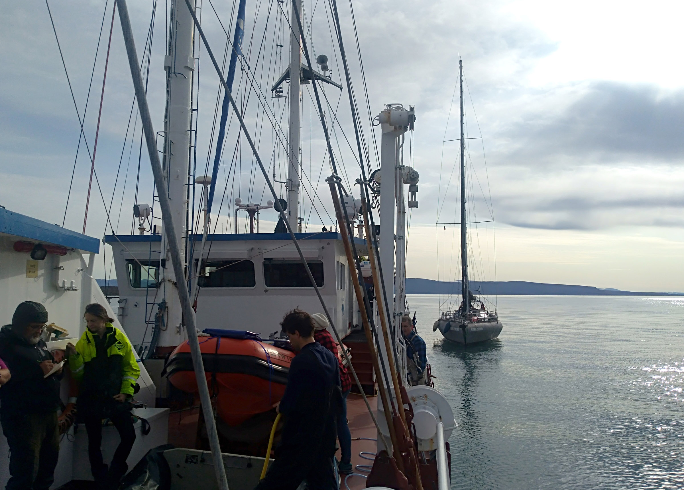
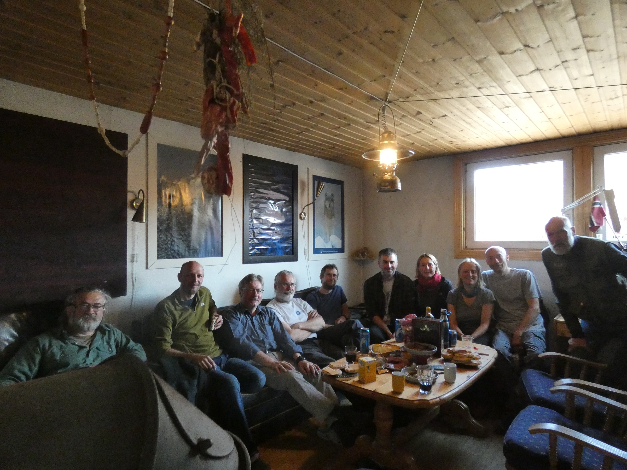
20:25 Arrival with Norwegian to Longyearbeyen, transport to OCEANIA at ByKaia, 21:30 – 23:30 Steaming to Gipsvika, onboard Lithuanian marine research team (Sergei Olenin, Vaciute), media Jakub Witek, environmentalist and veterinarian Andrzej Kruszewicz, plus IO PAN marine team (Jan Marcin Węsławski, Maria Włodarska-Kowalczuk, Joanna Legeżyńska, Lech Kotwicki, Kajetan Deja, Katarzyna Dragańska-Deja, Iwona Psuty – ichtyologist and Joachim Psuty - blogger) |
| ||
|
23.07.2019
Since midnight work on benthic stations – repetition of 1992 sampling in the same area, Van Venn grabs for macrofauna, sediment box core for chemistry and meiofauna, CTD and turbidity profile, seabed photography and filming with Drop Camera. Measurments of the the light on the sea surface, suspensions concentration in surface water. Between stations (12 completed, plus sediment cores for chemists) two land trips for the measurements of the suspensions and salinity in the vicinity of Gipselva – small tundra river. Collection of plastic liter on the shore – on both sides of the Bay – Skitvakten on SE and Gipshukodden on NW. |
| ||
|
24.07.2019
Steaming from Gipsvika to Yoldiabukta. Repetition of the old sampling stations from 1992, eight stations completed (same data as for Gipsvika) plus sediment cores. Peculiar view of the anoxic sediment in outer stations, with thin black layer of H2S on the surface of sediment – usually not observed in the Arctic fjords, probably effect of mass dacay of recently deposited organic debris. Coastal inspection at Stavneset, plastic litter documentation. |
| ||
|
25.07.2019
OCEANIA on the anchor in Nordfjorden near Samebreen, crew and equipment echange with yacht „Magnus Zaremba” participating in the same sampling campaign. The boat team is delivered from the ship to landing place at Sveasletta. OCEANIA returns to Longyearbyen for the AREX sampling ans boat team starts its activity. |
| ||
|
26.07.2019
Camp nr 1, coastal inspection for plastic, on the high coastal terraces subfossil Mytilus shells from the last climate optimum, in the coastal sands plastic bits (nurdle) and usual plastic debris. Later this day at low water, inspection of Ekmanfjord, Blonasletta and Flintholmen Island. Sampling the rich intertidal, plastic collection. Alive Mytilus in algal debris. |
| ||
|
27.07.2019
Wrapping up the camp nr 1 and trravel to Muslingodden, Bohemanflya and Bohemannesset for intertidal sampling. Setting the Camp nr 2 at Erdmanodden in Ymerbukta. Harbour seals near the camp. |
| ||
|
28.07.2019
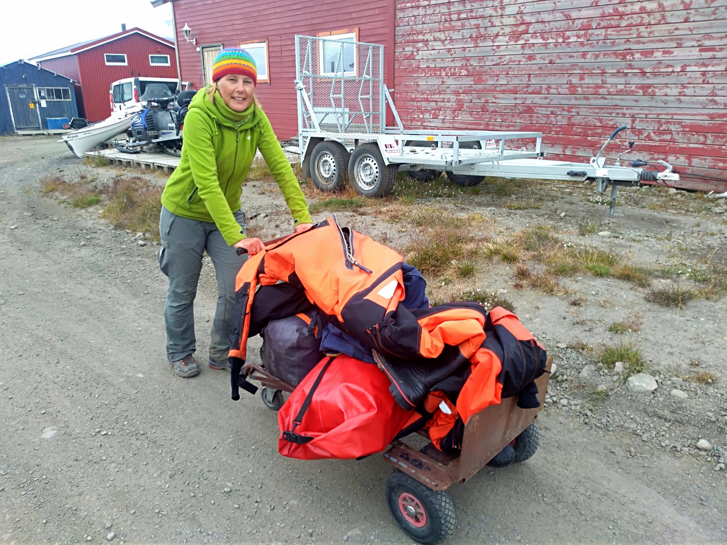
Sampling the intertidal at Tryghamna, Alkepynten, and inner part of Ymerbukta, polar bear behind the Alkehornet (NW), single walrus. |
| ||
|
29.07.2019
Sampling at Tundraodden and Ratangen. Mytilus in the intertidal at Ratangen, group of three plus two walruses on the shore of Tundraodden. |
| ||
|
30.07.2019
Wrapping up the camp, travel to Longyerbyan along the southern shore of Isfjorden, with light SW wind. From Campsite to Longyear trip took 3 hours. Altogether the boats covered over 280km in Isfjorden. Packing the samples and equipemnt fot he delivery to OCEANIA. Night at UNIS guesthouse. |
| ||
|
31.07.2019
Meeting with Magnus Zaremba team, unpacking their equipment at Pole Position store place. Travel to Longyearbyen airport. The end. |
|
Boat sampling map
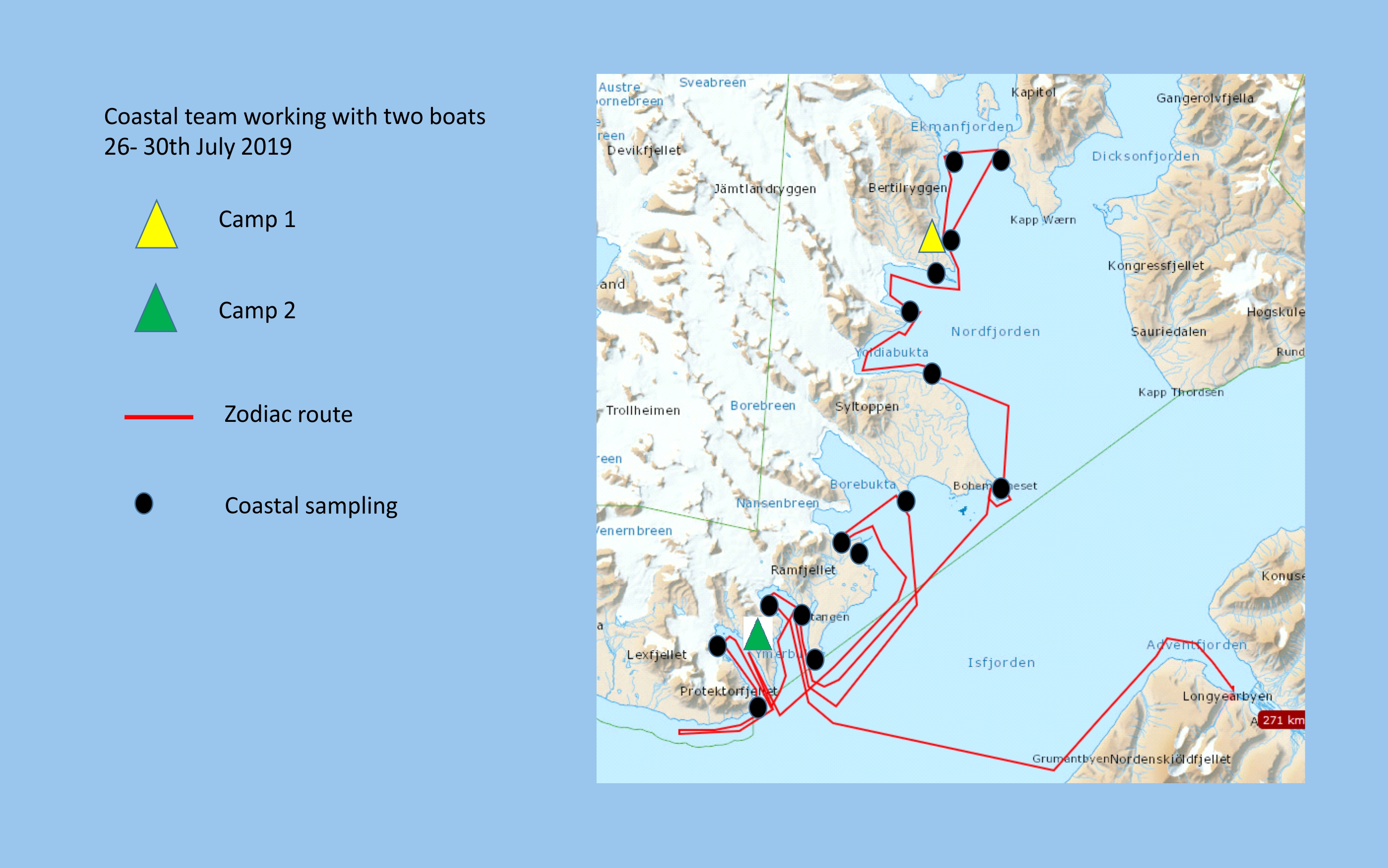
Coastal stations map
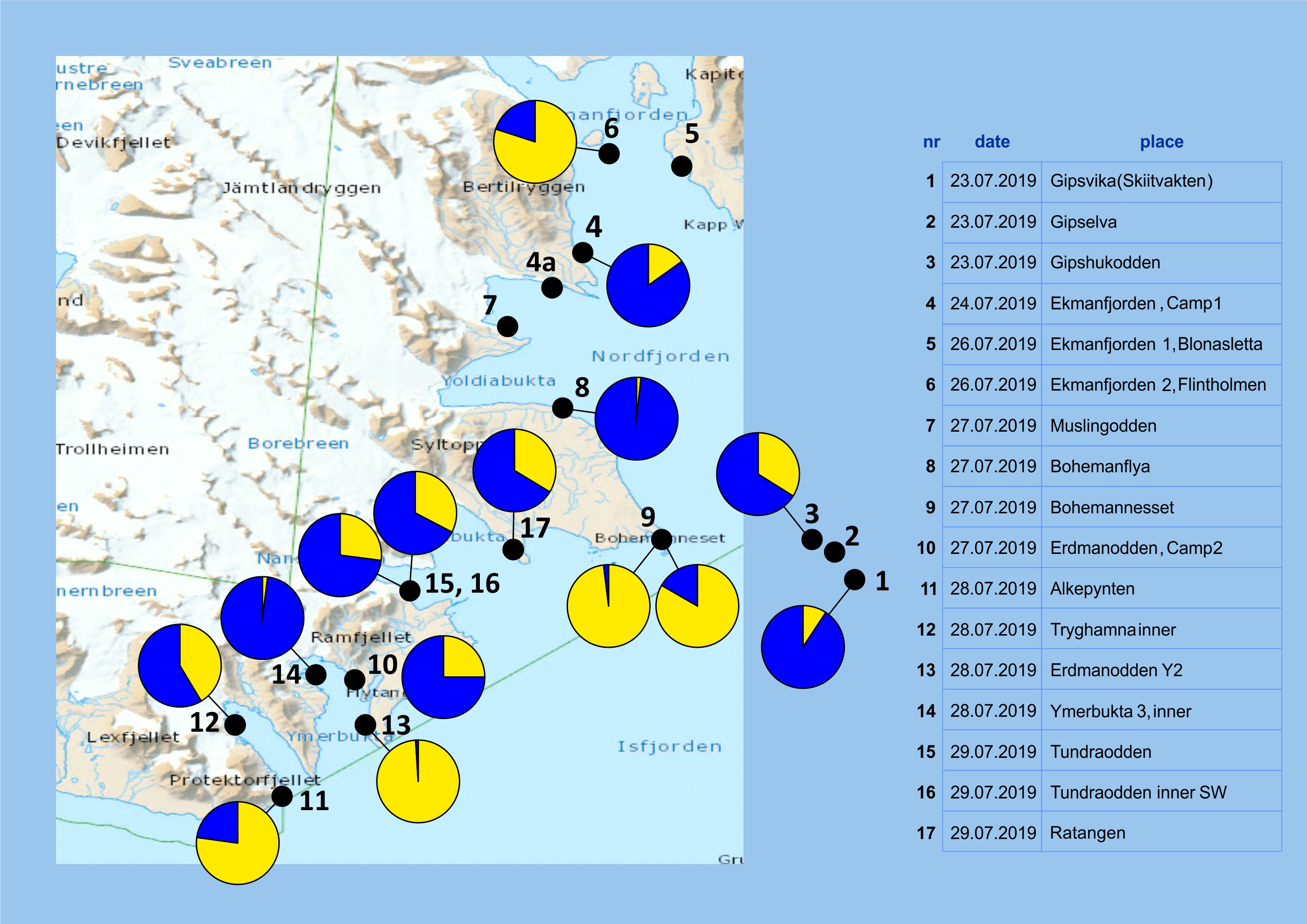
| station | place name | Gammarus oceanicus % | Gammarus setosus % |
| 1 | Gipsvika | 9 | 91 |
| 3 | Gipshukodden | 34 | 66 |
| 4 | Blonasletta Camp 1 | 15 | 85 |
| 6 | Flintholmen | 80 | 20 |
| 8 | Bohemanflya watt | 2 | 98 |
| 9 | Bohemannesset W | 98 | 2 |
| 9a | Bohemannesset E | 83 | 17 |
| 10 | Ymerbukta 1 (camp 2) | 25 | 75 |
| 11 | Alkepynten | 77 | 23 |
| 12 | Frontholmen | 41 | 59 |
| 13 | Ymerbukta 2 Erdmanodden | 99 | 1 |
| 14 | Ymerbukta 3 (Klaratopen) | 2 | 98 |
| 15 | Tundraodden | 27 | 73 |
| 16 | Tundraodden S(W) | 33 | 67 |
| 17 | Ratangen | 34 | 66 |
Gammarus sampling 2019 - data with subsamples
(animals collected under single stone separately)
| station subsamples |
place name | date | lat | long | Gammarus oceanicus n - specimens |
Gammarus setosus n - specimens |
Go% | Gs% | sum n - specimens |
| 1 | Gipsvika | 2019.07.23 | 78º24.833 | 16º35.928 | 4 | 39 | 9 | 91 | 43 |
| a | Gipsvika A | 0 | 9 | 0 | 100 | 9 | |||
| b | Gipsvika B | 3 | 15 | 17 | 83 | 18 | |||
| c | Gipsvika C | 1 | 15 | 6 | 94 | 16 | |||
| 3 | Gipshukodden | 2019.07.23 | 78º26.252 | 16º23.722 | 20 | 39 | 34 | 66 | 59 |
| a | Gipshukodden | 5 | 9 | 36 | 64 | 14 | |||
| b | Gipshukodden | 10 | 12 | 45 | 55 | 22 | |||
| c | Gipshukodden | 5 | 18 | 22 | 78 | 23 | |||
| 4 | Blonasletta Camp 1 | 2019.07.26 | 78º38.152 | 14º46.380 | 8 | 45 | 15 | 85 | 53 |
| 6 | Flintholmen | 2019.07.26 | 78º38.446 | 14º33.847 | 156 | 39 | 80 | 20 | 195 |
| a | Flintholmen | 10 | 4 | 71 | 29 | 14 | |||
| b | Flintholmen | 17 | 4 | 81 | 19 | 21 | |||
| c | Flintholmen | 49 | 8 | 86 | 14 | 57 | |||
| d | Flintholmen | 6 | 2 | 75 | 25 | 8 | |||
| e | Flintholmen | 23 | 2 | 92 | 8 | 25 | |||
| f | Flintholmen | 8 | 11 | 42 | 58 | 19 | |||
| g | Flintholmen | 43 | 8 | 84 | 16 | 51 | |||
| 8 | Bohemanflya watt | 2019.07.27 | 78º24.104 | 14º30.763 | 1 | 57 | 2 | 98 | 58 |
| 9 | Bohemannesset W | 2019.07.27 | 78º22.705 | 14º45.779 | 50 | 1 | 98 | 2 | 51 |
| 9 | Bohemannesset E | 2019.07.27 | 78º22.705 | 14º45.779 | 80 | 16 | 83 | 17 | 96 |
| a | Bohemannesset E | 6 | 1 | 86 | 14 | 7 | |||
| b | Bohemannesset E | 4 | 0 | 100 | 0 | 4 | |||
| c | Bohemannesset E | 7 | 1 | 88 | 13 | 8 | |||
| d | Bohemannesset E | 6 | 5 | 55 | 45 | 11 | |||
| e | Bohemannesset E | 7 | 1 | 88 | 13 | 8 | |||
| f | Bohemannesset E | 6 | 1 | 86 | 14 | 7 | |||
| g | Bohemannesset E | 3 | 1 | 75 | 25 | 4 | |||
| h | Bohemannesset E | 4 | 0 | 100 | 0 | 4 | |||
| i | Bohemannesset E | 7 | 1 | 88 | 13 | 8 | |||
| j | Bohemannesset E | 17 | 2 | 89 | 11 | 19 | |||
| k | Bohemannesset E | 13 | 3 | 81 | 19 | 16 | |||
| 10 | Ymerbukta 1 (camp 2) | 2019.07.28 | 78º16.645 | 14º01.563 | 21 | 63 | 25 | 75 | 84 |
| a | Ymerbukta 1 | 5 | 8 | 38 | 62 | 13 | |||
| b | Ymerbukta 1 | 9 | 37 | 20 | 80 | 46 | |||
| c | Ymerbukta 1 | 7 | 18 | 28 | 72 | 25 | |||
| 11 | Alkepynten | 2019.07.28 | 78º12.643 | 13º50.607 | 44 | 13 | 77 | 23 | 57 |
| a | Alkepynten | 4 | 3 | 57 | 43 | 7 | |||
| b | Alkepynten | 6 | 2 | 75 | 25 | 8 | |||
| c | Alkepynten | 6 | 1 | 86 | 14 | 7 | |||
| d | Alkepynten | 10 | 1 | 91 | 9 | 11 | |||
| e | Alkepynten | 5 | 1 | 83 | 17 | 6 | |||
| f | Alkepynten | 4 | 5 | 44 | 56 | 9 | |||
| g | Alkepynten | 5 | 0 | 100 | 0 | 5 | |||
| h | Alkepynten | 4 | 0 | 100 | 0 | 4 | |||
| 12 | Frontholmen | 2019.07.28 | 78º14.738 | 13.46.083 | 84 | 119 | 41 | 59 | 203 |
| a | Frontholmen | 15 | 32 | 32 | 68 | 47 | |||
| b | Frontholmen | 0 | 9 | 0 | 100 | 9 | |||
| c | Frontholmen | 3 | 3 | 50 | 50 | 6 | |||
| d | Frontholmen | 26 | 8 | 76 | 24 | 34 | |||
| e | Frontholmen | 13 | 13 | 50 | 50 | 26 | |||
| f | Frontholmen | 6 | 17 | 26 | 74 | 23 | |||
| g | Frontholmen | 13 | 17 | 43 | 57 | 30 | |||
| h | Frontholmen | 8 | 20 | 29 | 71 | 28 | |||
| 13 | Ymerbukta 2 Erdmanodden | 2019.07.28 | 78º14.984 | 14º03.292 | 141 | 2 | 99 | 1 | 143 |
| a | Ymerbukta 2 Erdmanodden | 27 | 2 | 93 | 7 | 29 | |||
| b | Ymerbukta 2 Erdmanodden | 67 | 0 | 100 | 0 | 67 | |||
| c | Ymerbukta 2 Erdmanodden | 47 | 0 | 100 | 0 | 47 | |||
| 14 | Ymerbukta 3 (Klaratopen) | 2019.07.28 | 78º17.194 | 13º54.990 | 2 | 91 | 2 | 98 | 93 |
| a | Ymerbukta 3 (Klaratopen) | 2 | 42 | 5 | 95 | 44 | |||
| b | Ymerbukta 3 (Klaratopen) | 0 | 17 | 0 | 100 | 17 | |||
| c | Ymerbukta 3 (Klaratopen) | 0 | 32 | 0 | 100 | 32 | |||
| 15 | Tundraodden | 2019.07.29 | 78º20.619 | 14º14.003 | 20 | 54 | 27 | 73 | 74 |
| a | Tundraodden | 5 | 17 | 23 | 77 | 22 | |||
| b | Tundraodden | 4 | 2 | 67 | 33 | 6 | |||
| c | Tundraodden | 7 | 23 | 23 | 77 | 30 | |||
| d | Tundraodden | 3 | 5 | 38 | 63 | 8 | |||
| e | Tundraodden | 1 | 7 | 13 | 88 | 8 | |||
| 16 | Tundraodden S(W) | 2019.07.29 | 78º20.397 | 14º14.634 | 32 | 66 | 33 | 67 | 98 |
| a | Tundraodden S(W) | 4 | 11 | 27 | 73 | 15 | |||
| b | Tundraodden S(W) | 2 | 8 | 20 | 80 | 10 | |||
| c | Tundraodden S(W) | 10 | 28 | 26 | 74 | 38 | |||
| d | Tundraodden S(W) | 16 | 19 | 46 | 54 | 35 | |||
| 17 | Ratangen | 2019.07.29 | 78º22.084 | 14º24.653 | 66 | 130 | 34 | 66 | 196 |
| a | Ratangen | 0 | 6 | 0 | 100 | 6 | |||
| b | Ratangen | 10 | 3 | 77 | 23 | 13 | |||
| c | Ratangen | 16 | 9 | 64 | 36 | 25 | |||
| d | Ratangen | 7 | 11 | 39 | 61 | 18 | |||
| e | Ratangen | 5 | 30 | 14 | 86 | 35 | |||
| f | Ratangen | 12 | 26 | 32 | 68 | 38 | |||
| g | Ratangen | 7 | 24 | 23 | 77 | 31 | |||
| h | Ratangen | 9 | 21 | 30 | 70 | 30 |
Plastic litter collection
| date | hour | place name | distance [m] | photo | nr of items, est. weight | remarks |
| 2019.07.23 | 20.30 | Gipselva | 300 |  | no organisms attached | |
| 2019.07.23 | 23.38 | Gipshukodden | 300 |  | no organisms attached | |
| 2019.07.24 | 21.32 | Stavnesset, Nordfjorden | 300 |  | no organisms attached | |
| 2019.07.25 | 22.11 | Sveasletta, Camp 1, South part | 100 |  | Semibalanus balanoides on the plastic bulb | |
| 2019.07.26 | 00.03 | Sveasletta, Camp 1, North | 100 |  | no organisms attached | |
| 2019.07.26 | 12.06 | Ekmanfjord | 300 |  | no organisms attached | |
| 2019.07.27 | 10.25 | Muslingodden | 300 |  | no organisms attached | |
| 2019.07.27 | 12.42 | Bohemanflya - Drangen | 300 |  | no organisms attached | |
| 2019.07.27 | 13.03 | Bohemanflya - Drangen | 300 |  | no organisms attached | |
| 2019.07.27 | 15.40 | Bohemannesset, Fyr | 300 |  | no organisms attached | |
| 2019.07.29 | 12.38 | Tundraodden 1 | 100 |  | no organisms attached | |
| 2019.07.29 | 12.38 | Tundraodden 2 | 100 |  | no organisms attached | |
| 2019.07.29 | 12.56 | Tundraodden 3 | 100 |  | no organisms attached | |
| 2019.07.29 | 13.05 | Tundraodden 4 | 100 |  | no organisms attached |
Sampling stations
| nr | date | hour | place name | station code | lat | long | depth | work completed | remarks |
| 1 | 2019.07.22 | 23.49 | Gipsvika | G1 | 78º25.761 | 16º18.511 | 75 m | CTD, turbidity, 3x VV, box core, light, susp.; drop camera | |
| 2 | 2019.07.23 | 00.59 | Gipsvika | G2 | 78º25.558 | 16º22.243 | 60 m | CTD, turbidity, 3x VV, box core, light, susp.; drop camera | |
| 3 | 2019.07.23 | 01.33 | Gipsvika | G6 | 78º25.424 | 16º26.757 | 52 m | CTD, turbidity, 3x VV, box core, light, susp.; drop camera | |
| 4 | 2019.07.23 | 02.13 | Gipsvika | G7 | 78º25.119 | 16º28.005 | 51 m | CTD, turbidity, 3x VV, box core, light, susp.; drop camera | |
| 5 | 2019.07.23 | 02.42 | Gipsvika | G8 | 78º24.967 | 16º31.105 | 50 m | CTD, turbidity, 3x VV, box core, light, susp.; drop camera | |
| 6 | 2019.07.23 | 03.07 | Gipsvika | G10 | 78º24.669 | 16º30.008 | 50 m | CTD, turbidity, 3x VV, box core, light, susp.; drop camera | |
| 7 | 2019.07.23 | 03.42 | Gipsvika | G11 | 78º24.721 | 16º34.014 | 30 m | CTD, turbidity, 3x VV, box core, light, susp.; drop camera | |
| 8 | 2019.07.23 | 04.11 | Gipsvika | G12 | 78º24.391 | 16º33.784 | 54 m | CTD, turbidity, 3x VV, box core, light, susp.; drop camera | |
| 9 | 2019.07.23 | 18.52 | Gipsvika | G14 | 78º25.611 | 16º32.251 | 30 m | CTD, turbidity, 3x VV, box core, light, susp.; drop camera | |
| 10 | 2019.07.23 | 23.02 | Gipshukodden | Ghd | 78º26.252 | 16º23.722 | 0 m, low water | Gammarus, Algae, photo, genetics, meiofauna | |
| 11 | 2019.07.24 | 07.24 | Yoldiabukta | Yol1 | 78º28.739 | 14º37.285 | 67 m | CTD, turbidity, 3x VV, box core, light, susp.; drop camera | H2S, black sediment on the surface |
| 12 | 2019.07.24 | 09.36 | Yoldiabukta | Yol2 | 78º29.699 | 14º36.879 | 78 m | CTD, turbidity, 3x VV, box core, light, susp.; drop camera | |
| 13 | 2019.07.24 | 10.15 | Yoldiabukta | Yol3 | 78º30.531 | 14º35.144 | 68 m | CTD, turbidity, 3x VV, box core, light, susp.; drop camera | |
| 14 | 2019.07.24 | 13.56 | Yoldiabukta | Yol4 | 78º28.769 | 14º27.320 | 40 m | CTD, turbidity, 3x VV, box core, light, susp.; drop camera | |
| 15 | 2019.07.24 | 13.04 | Yoldiabukta | Yol5 | 78º29.534 | 14º27.306 | 50 m | CTD, turbidity, 3x VV, box core, light, susp.; drop camera | |
| 16 | 2019.07.24 | 11.20 | Yoldiabukta | Yol6 | 78º29.893 | 14º25.978 | 60 m | CTD, turbidity, 3x VV, box core, light, susp.; drop camera | |
| 17 | 2019.07.24 | 15.20 | Yoldiabukta | Yol7 | 78º29.099 | 14º21.959 | 40 m | CTD, turbidity, 3x VV, box core, light, susp.; drop camera | |
| 18 | 2019.07.26 | Blonasletta | E1 | 78º38.152 | 14º46.380 | 0 m, low water | Gammarus, Algae, photo, genetics, plastic | ||
| 19 | 2019.07.26 | Flintholmen | E2 | 78º38.446 | 14º33.847 | 0 m, low water | Gammarus, Algae, photo, genetics, plastic | Mytilus sp. Intertidal, at LW among Fucus | |
| 20 | 2019.07.27 | 12.49 | Bohemanflya | BHhmn N | 78º24.104 | 14º30.763 | 0 m, low water | Gammarus, Algae, photo, genetics, plastic | |
| 21 | 2019.07.27 | 14.54 | Bohemannesset | Bhmn | 78º22.705 | 14º45.779 | 0 m, low water | Gammarus, Algae, photo, genetics, meiofauna | |
| 22 | 2019.07.27 | 20.44 | Erdmannodden | camp 2 | 78º16.645 | 14º01.563 | 0 m, low water | Gammarus, Algae, photo, genetics, | |
| 23 | 2019.07.28 | 17.09 | Erdmanodden | Ymer2 | 78º14.984 | 14º03.292 | 0 m, low water | Gammarus, Algae, photo, genetics, | |
| 24 | 2019.07.28 | 18.06 | Ymerbukta | Ymer 3 | 78º17.20194 | 13.54.990 | 0 m, low water | Gammarus, Algae, photo, genetics, plastic | |
| 25 | 2019.07.28 | 17.30 | Alkepynten | Alh | 78º12.643 | 13º50.607 | 0 m, low water | Gammarus, Algae, photo, genetics, plastic | |
| 26 | 2019.07.28 | 18.00 | Frontholmen | Trygg.inner | 78º14.738 | 13.46.083 | 0 m, low water | Gammarus, Algae, photo, genetics, plastic | |
| 27 | 2019.07.29 | 14.25 | Tundraodden | T_odd | 78º20.619 | 14º14.003 | 0 m, low water | Gammarus, Algae, photo, genetics, | |
| 28 | 2019.07.29 | 15.21 | Tundraodden | Todd_S/W | 78º20.397 | 14º14.634 | 0 m, low water | Gammarus, Algae, photo, genetics, | |
| 29 | 2019.07.29 | 15.40 | Ratangen | Rtg | 78º22.084 | 14º24.653 | 0 m, low water | Gammarus, Algae, photo, genetics, plastic |
Sampling stations
| nr | date | place | photos |
| 1 | 23.07 2019 | Gipsvika (Skiitvakten) |        |
| 2 | 23.07 2019 | Gipselva |     |
| 3 | 23.07 2019 | Gipshukodden |         |
| 4 | 24.07 2019 | Ekmanfjorden, Camp 1 |      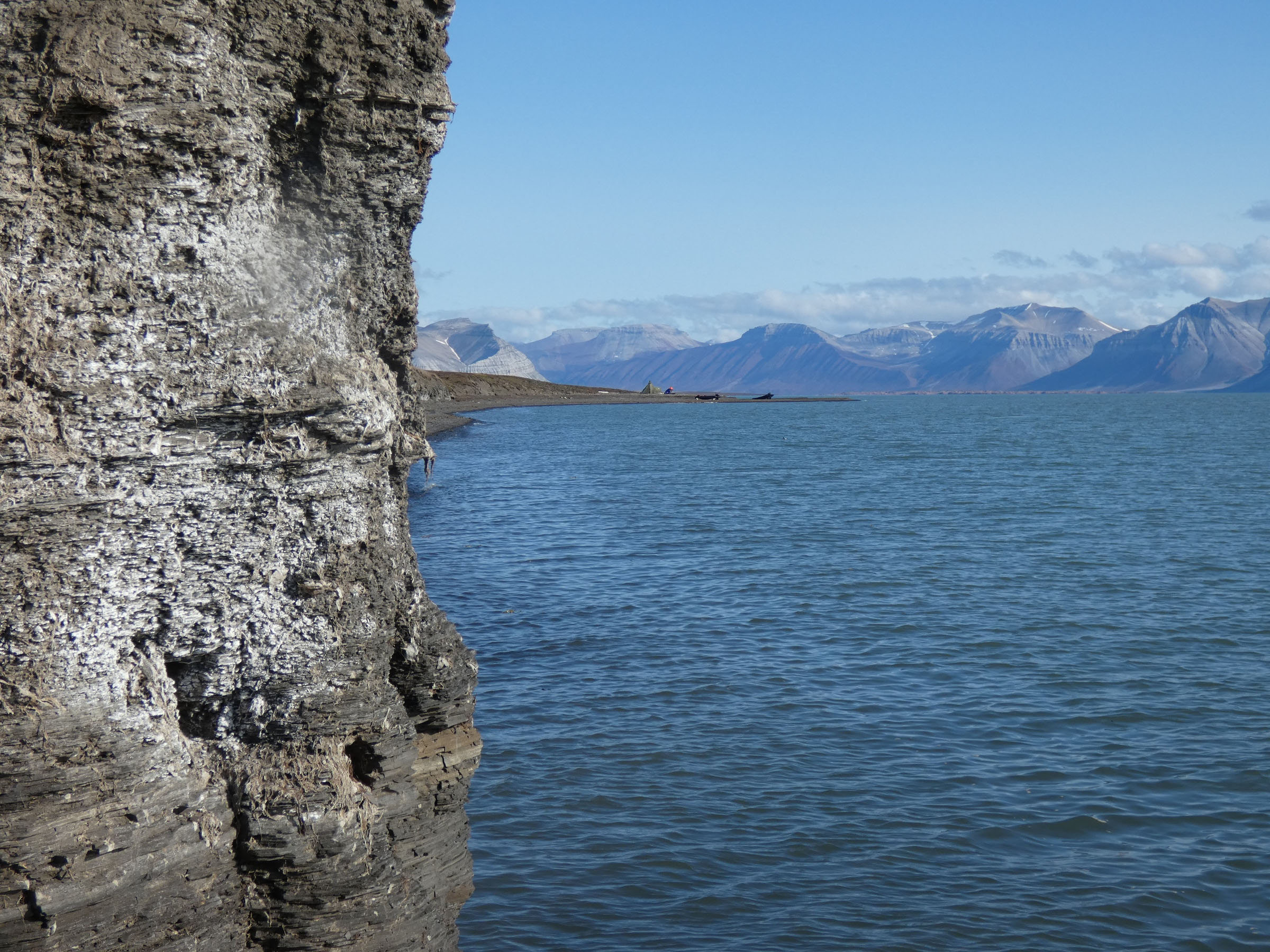  |
| 5 | 26.07 2019 | Ekmanfjorden 1, Blonasletta |        |
| 6 | 26.07 2019 | Ekmanfjorden 2, Flintholmen |           |
| 7 | 27.07 2019 | Muslingodden |   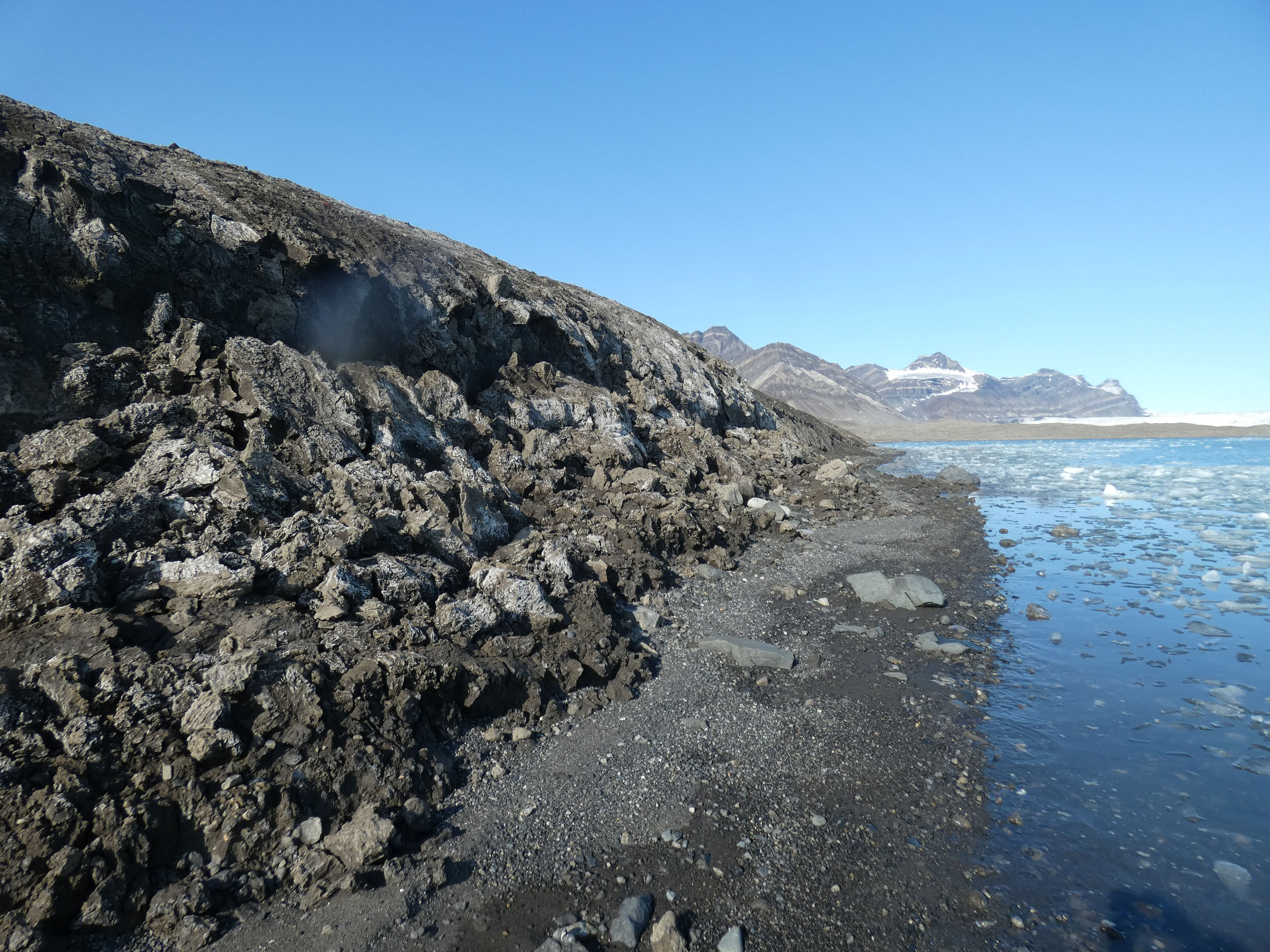  |
| 8 | 27.07 2019 | Bohemanflya |      |
| 9 | 27.07 2019 | Bohemannesset | 


 |
| 10 | 27.07 2019 | Erdmanodden, Camp 2 |       |
| 11 | 28.07 2019 | Alkepynten |      |
| 12 | 28.07 2019 | Tryghamna inner |    |
| 13 | 28.07 2019 | Erdmanodden Y2 |         |
| 14 | 28.07 2019 | Ymerbukta 3, inner |        |
| 15 | 29.07 2019 | Tundraodden |          |
| 16 | 29.07 2019 | Tundraodden inner SW |       |