Field work reports
Status report 2023
Between 21-24 th of August 2023 the reconaissance survey for the project have been completed from the r/v OCEANIa in Isfjorden area. We have checked seven locations, in the outer and inner Isfjorden, collecting photos of the coast (driftwood) and manually collecting macroplastic on the 100 m long units of the shore.
The localities visited:
| place | latitude | longitude | note | photo |
| Wilkinsbukta | 78°12.319’ | 13°09.054’ | four plastic transects |  |
| Tryghamna | 78°15.537’ | 13°46.475’ | three plastic transects |  |
| Randvika | 78°03.692’ | 13°37.644’ | six plastic transects |  |
| Fredheim | 78°21.315’ | 16°55.938’ | five plastic transecs |  |
| Bjonapynten | 78°23.115’ | 16°50.900’ | five plastic transecs |  |
| Tunabreen | 78°25.735’ | 17o22.498’ | five plastic transecs |  |
| Gipsvika | 78°25.621’ | 16°35.729’ | eight plastic transecs |  |
Status report 2024
Between 15th and 30th August 2024 four groups were collected data for the project in the field.
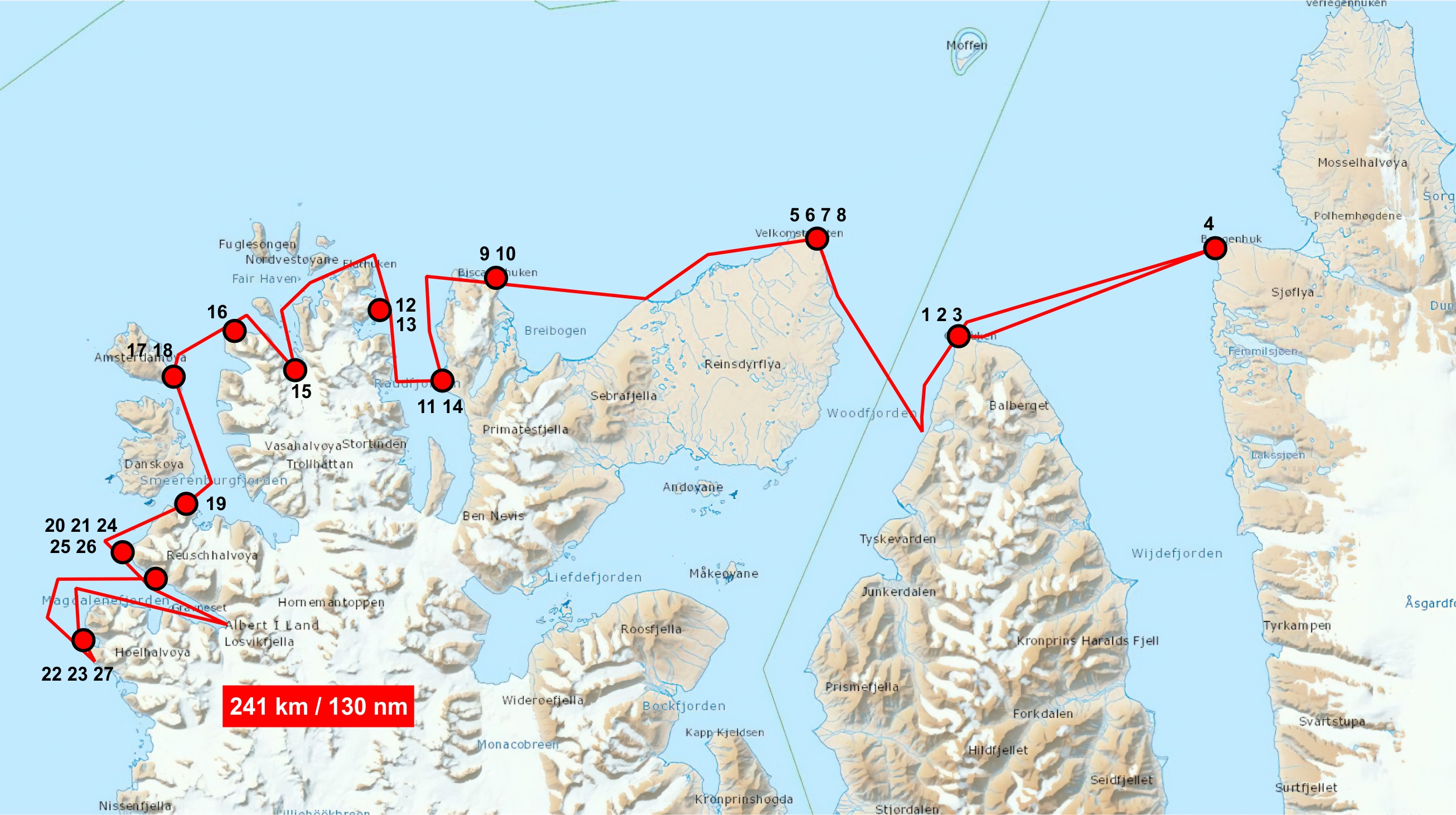
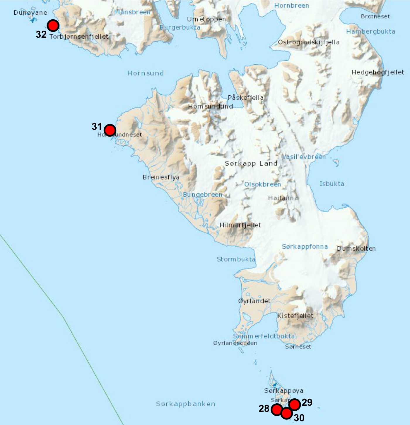
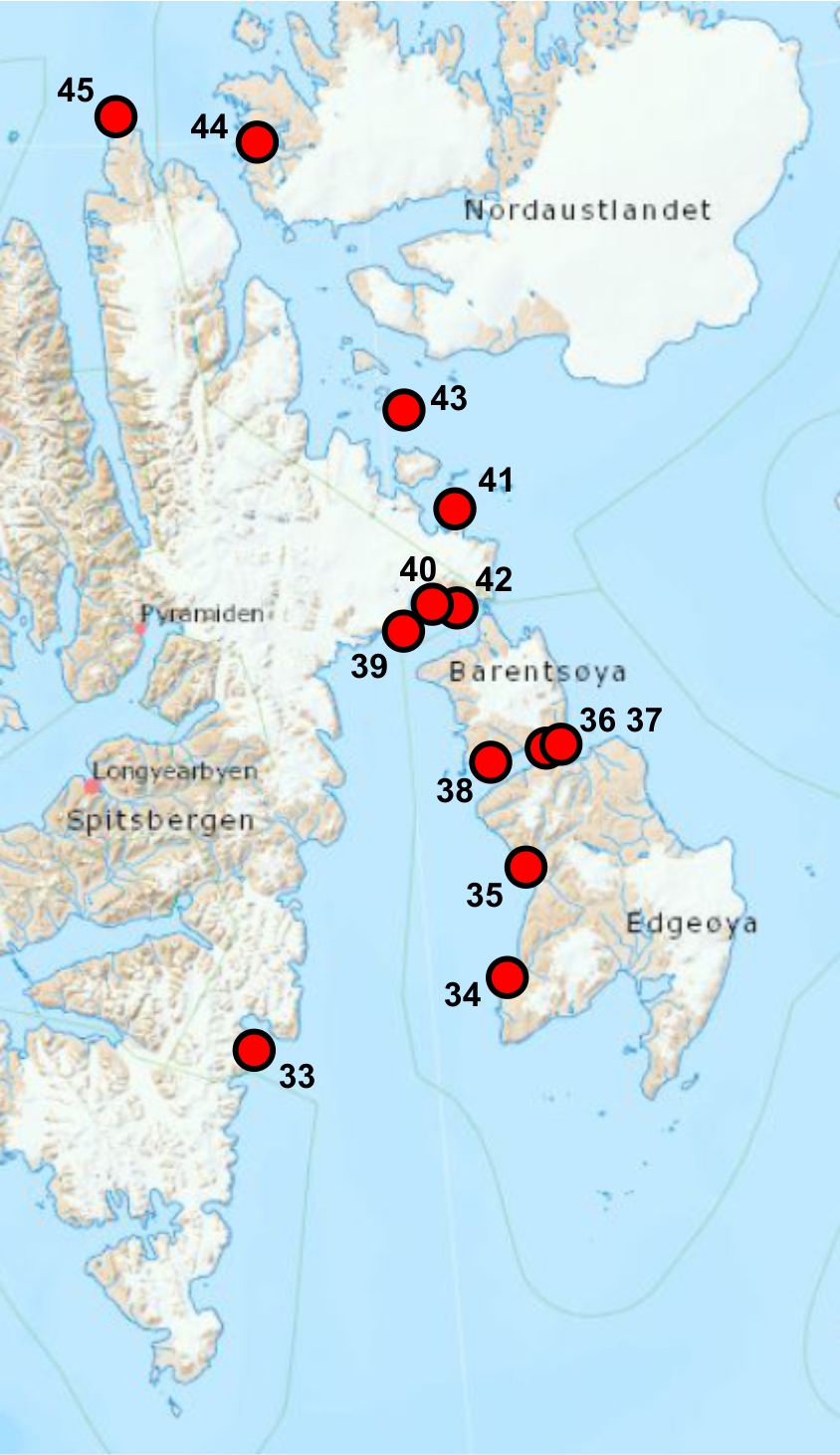
Fig. 1 Sampling stations maps

Sampling stations and route covered by boat team North West Spitsbergen
18-26th August 2024, RIS 12284 |

Sampling stations covered by team
South Spitsbergen 12-17th August 2024 |

Sampling stations covered
by team East Spitsbergen
15-30th August 2024
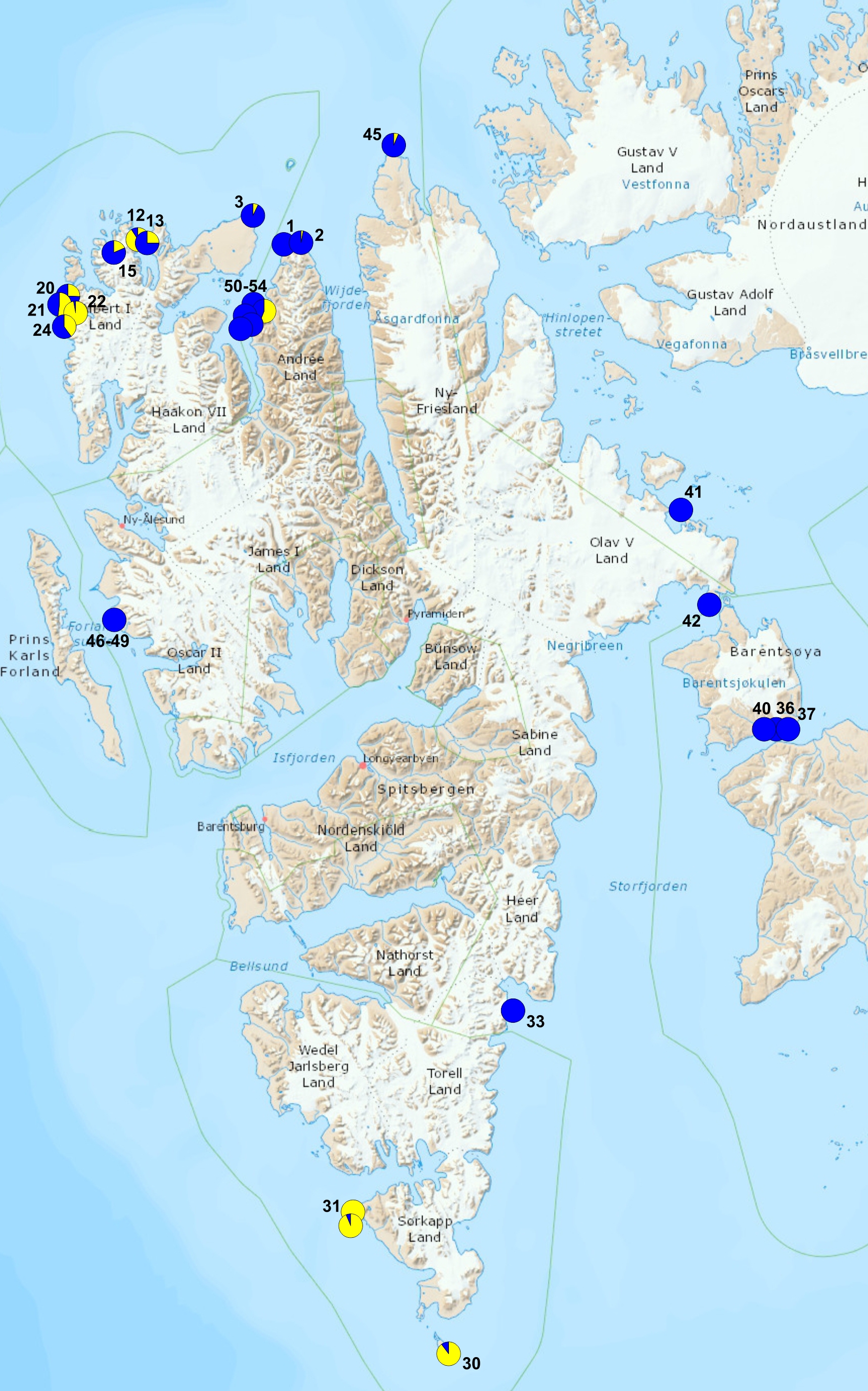
|

Gammarus species
distribution: blue G.setosus,
yellow G. oceanicus
|
Table 1. Data from sampling on NW Spitsbergen coast.
| nr | place name | latitude | longitude | GPS
nr | day | hour | coast
type | plastic count area | Mytilus
- living | Fucus | Littorina | Gamm.
oceanicus % | Gamm.
setosus % | remarks | photo |
| 1 |
Grahuken hytte |
79.47.274 |
14.27.421 |
55 |
2024.08.18 |
07.03 |
flat, gravel and stones beach with low skjerra |
100m along dift zone |
|
|
|
0 |
100 |
|
 |
| 2 |
Grahuken Tip |
79.48.045 |
14.32.019 |
56 |
2024.08.18 |
10.15 |
flat, gravel and stones beach with low skjerra |
100m along dift zone |
|
x |
|
3 |
97 |
|
 |
| 3 |
Grahuken E |
79.47.833 |
14.32.602 |
57 |
2024.08.18 |
10.37. |
flat, gravel and stones beach with low skjerra |
100m along dift zone |
|
x |
|
|
|
|
 |
| 4 |
Bangehuk |
79.48.455 |
15.37.562 |
59 |
2024.08.18 |
14.23 |
steep stony beach with low skjerra |
100m along dift zone |
|
x |
|
|
|
|
 |
| 5 |
Velkomspynten E |
79.51.549. |
13.51.778 |
60 |
2024.08.19 |
09.26 |
flat, gravel and stones beach with low skjerra |
100m along dift zone |
|
x |
|
7 |
93 |
number of Ascophyllum fronds drifted ashore |
 |
| 6 |
Velkomspynten Tip |
79.51.682 |
13.51.595 |
61 |
2024.08.19 |
10.10 |
flat, gravel and stones beach with low skjerra |
100m along dift zone |
|
x |
|
|
|
|
 |
| 7 |
Velkomspynten W |
79.52.632 |
13.43.855 |
62 |
2024.08.19 |
|
flat, gravel and stones beach with low skjerra |
100m along dift zone |
|
x |
|
|
|
|
 |
| 8 |
Velkomspynten WW |
79.52.343 |
13.41.918 |
63 |
2024.08.19 |
12.37 |
flat, gravel and stones beach with low skjerra |
100m along dift zone |
|
x |
|
|
|
|
 |
| 9 |
Biskayarhuken E |
79.55.006 |
12.22.751 |
64 |
2024.08.20 |
14.20 |
flat, gravel and stones beach with low skjerra |
100m along dift zone |
|
x |
|
|
|
walruses 2 ind. Haul out |
 |
| 10 |
Biskayarhuken
- Lingbukta |
79.50.009 |
12.22.741 |
65 |
2024.08.20 |
14.25 |
flat, gravel and stones beach with low skjerra |
100m along dift zone |
|
x |
|
|
|
Mytilus on fishing box |
 |
| 11 |
Raudfjordhytta |
79.44.581 |
12.12.065 |
66 |
2024.08.20 |
15.41 |
flat, gravel and stones beach with low skjerra |
100m along dift zone |
x |
|
|
|
|
Ivory gull at the hut |
 |
| 12 |
Flathuken |
79.50.463 |
11.47.449 |
67 |
2024.08.21 |
09.55 |
steep stony beach with boulders |
100m along dift zone |
|
x |
x |
91 |
9 |
|
 |
| 13 |
Hundneset |
79.48.321 |
11.50.844 |
69 |
2024.08.21 |
10.25 |
steep stony beach with boulders |
100m along dift zone |
|
x |
x |
25 |
75 |
|
 |
| 14 |
Raudfjord
- Snotinden |
79.45.037 |
11.55.865 |
70 |
2024.08.21 |
12.30 |
sandy beach with boulders |
100m along dift zone |
|
x |
|
|
|
|
 |
| 15 |
Fuglefjorden
skjerra |
79.46.719 |
11.27.458 |
71 |
2024.08.22 |
11.05 |
high skjerra, rocky walls |
100m along dift zone |
|
x |
x |
19 |
81 |
|
 |
| 16 |
Fuglepynten |
79.46.936 |
11.12.874 |
72 |
2024.08.22 |
11.46 |
steep stony beach with boulders |
100m along dift zone |
|
x |
|
|
|
|
 |
| 17 |
Smeerenbukta |
79.44.711 |
10.57.756 |
73 |
2024.08.22 |
12.45 |
sandy beach with boulders |
1 m2 series of photos |
|
|
|
|
|
|
 |
| 18 |
Smeerenburgodden |
79.44.055 |
10.58.893 |
79 |
2024.08.22 |
13.37 |
sandy beach with boulders |
100m along dift zone |
|
|
|
|
|
|
 |
| 19 |
Bjornhamna |
79.38.449 |
10.58.974 |
80 |
2024.08.22 |
14.37 |
steep stony beach |
100m along dift zone |
|
x |
|
|
|
|
 |
| 20 |
Gravnesoden |
79.33.637 |
11.02.065 |
81 |
2024.08.23 |
07.17 |
flat, gravel and stones beach with low skjerra |
100m along dift zone |
|
x |
|
26 |
74 |
|
 |
| 21 |
Alkekongen beach camp |
79.34.311 |
11.03.934 |
82 |
2024.08.23 |
08.25 |
flat, gravel and stones beach with low skjerra |
100m along dift zone |
|
x |
|
52 |
48 |
|
 |
| 22 |
Hamburgbukta S shore |
79.31.575 |
10.41.637 |
83 |
2024.08.24 |
09.18 |
flat, gravel and stones beach with low skjerra |
100m along dift zone |
x |
x |
x |
97 |
3 |
Phoca vitulina 8-11 ind. |
 |
| 23 |
Hamburgbukta N shore |
79.31.895 |
10.43.222 |
85 |
2024.08.24 |
13.18 |
flat, gravel and stones beach with low skjerra |
100m along dift zone |
|
x |
|
|
|
polar bear moving S alongshore |
 |
| 24 |
Magdalenafjorden
- Methenbreen |
79.33.558 |
11.13.195 |
86 |
2024.08.25 |
10.25 |
steep stony beach with boulders |
100m along dift zone |
|
x |
|
40 |
60 |
|
 |
| 25 |
Magdalenafjorden
- Alkebreen |
79.33.875 |
11.09.688 |
87 |
2024.08.25 |
12.23 |
steep stony beach with boulders |
100m along dift zone |
|
x |
|
|
|
peat sample |
 |
| 26 |
Magdalenafjorden
- Gullybukta |
79.33.462 |
79.33.558 |
88 |
2024.08.25 |
16.12 |
sandy beach with boulders |
100m along dift zone |
|
|
|
|
|
walruses 11-12 ind. Haul out |
 |
| 27 |
Hamburgbukta
open sea shore |
79.31.686 |
10.40.173 |
83A |
2024.08.24 |
11.30 |
steep stony beach with boulders, rocky walls |
100m along dift zone |
|
x |
|
|
|
peat sample |
 |
| 46 |
Hornbaeckbukta 1
Kaffioyra |
78.40,869 |
11.49,971 |
|
|
|
|
|
|
|
|
0 |
100 |
|
|
| 47 |
Hornbaeckbukta 2
Kaffioyra |
78.40,869 |
11.49,971 |
|
|
|
|
|
|
|
|
0 |
100 |
|
|
| 48 |
Hornbaeckbukta 3
Kaffioyra |
78.40,869 |
11.49,971 |
|
|
|
|
|
|
|
|
0 |
100 |
|
|
| 49 |
Hornbaeckbukta 4
Kaffioyra |
78.40,869 |
11.49,971 |
|
|
|
|
|
|
|
|
0 |
100 |
|
|
| 50 |
Woodfjorden 2
Oceania |
79.6,522 |
14.03,767' |
|
|
|
|
|
|
|
|
0 |
100 |
|
|
| 51 |
Woodfjorden 6
Oceania |
79.6,522 |
14.03,767 |
|
|
|
|
|
|
|
|
56 |
44 |
|
|
| 52 |
Woodfjorden 7
Oceania |
79.6,522 |
14.03,767 |
|
|
|
|
|
|
|
|
0 |
100 |
|
|
| 53 |
Woodfjorden 9
Oceania |
79.6,522 |
14.03,767 |
|
|
|
|
|
|
|
|
0 |
100 |
|
|
| 54 |
Woodfjorden 11
Oceania |
79.6,522 |
14.03,767 |
|
|
|
|
|
|
|
|
0 |
100 |
|
|
North West Spitsbergen team, operated from yacht r/v OCEANIA and two zodiac boats collected 27 sampling stations (see the map and the table).
Team consisted of: Jan Marcin Węsławski, Lech Kotwicki, Jakub Witek, Marcin Górski and Błażej Kotwicki.
Table 2. Data from sampling on South Spitsbergen coast.
| nr | place name | latitude | longitude | GPS
nr | day | hour | coast
type | plastic count area | Mytilus
- living | Fucus | Littorina | Gamm.
oceanicus % | Gamm.
setosus % | remarks | photo |
| 28 | Sorkappoya Sorkappvatnet W | 76°27.995' | 16°34.241' | | 2024.08.12 | | flat, stony beach | 10 areas 10 x 15 m, four photos each | | x | | | | |  |
| 29 | Sorkappoya Sorkappvatnet E | 76°28.164' | 16°35.045' | | 2024.08.12 | | flat, gravel, stony beach with skjerra | 10 areas 10 x 15 m, four photos each 4 | | x | | | | |  |
| 30 | Sorkappoya | 76°27.866' | 16°34.613' | | 2024.08.12 | | flat, stony beach | none | | x | | 90 | 10 | |  |
| 31 | Palffyodden | 76°53.906' | 15°31.162' | | 2024.08.15 | | skjerra with stony beach | none | | x | | 100 | 0 | |  |
| 32 | Hyttevika | 77°02.910' | 15°08.317' | | 2024.08.17 | | flat stony beach with skjerra | none | | x | | 95 | 5 | |  |
South Spitsbergen team operated with the support of yacht Ocean B, and one zodiac team consisted of Ryszard Siwecki, Adam Siwecki and Paweł Paździor.
Table 3. Data from sampling on East Spitsbergen coast.
| nr | place name | latitude | longitude | GPS
nr | day | hour | coast
type | plastic count area | Mytilus
- living | Fucus | Littorina | Gamm.
oceanicus % | Gamm.
setosus % | remarks | photo |
| 33 | Hambergbukta
(Spits. East) | 77°02’19’’
| 17°04’38’’ | | 2024.08.20 | | low moraine beach, sand, gravel, stones | 3(100 x 20m) | | | | | | freshwater outfloiw |  |
| 34 | Russebukta (Edgeøya) | 77°35’16’’
| 21°00’05’’ | | 2024.08.21 | | low gravel beach, rocks | 100 x 30m | | x | | 0 | 100 | skjerra |  |
| 35 | Diskobukta (Edgeøya) | 77°49’24’’
| 21°21’44’’ | | 2024.08.22 | | low, gravel and stony beach | 2(100 x 10m) | | | | | | no driftwood |  |
| 36 | Kapp Waldburg (Barentsøya) | 78°15’31’’ | 21°56’13’’ | | 2024.08.23 | | low gravel beach | 100 x 10m | | | | | | strong currents |  |
| 37 | Kapp Waldburg (Barentsøya) | 78°15’44’’ | 22°03’49’’ | | 2024.08.23 | | narrow, low, initial stony beach | | | | | 0 | 100 | no driftwood, strong currents |  |
| 38 | Sundbukta (Barentsøya) | 78°13’08’’ | 20°59’31’’ | | 2024.08.24 | | low, gravel and stony beach | 3(10 x 100m) | | | | 0 | 100 | |  |
| 39 | Anderssonbukta (Barentsøya) | 78°18’50’’ | 20°37’27’’ | | 2024.08.25 | | low, gravel and stony beach | 100 x 5m | | x | | | | narrow driftline |  |
| 40 | Edlundhamna (Spits. East) | 78°37’17’’ | 20°00’39’’ | | 2024.08.26 | | low, boulder, sand and stony beach | 100 x 10m | | | | 0 | 100 | |  |
| 41 | Kapp Weyprecht (Spits. East) | 78°53’39’’ | 20°53’20’’ | | 2024.08.27 | | low, boulder, sand and stony beach | 100 x 20m | | | | 0 | 100 | |  |
| 42 | Straumslandet (Spits. East) | 78°41’02’’ | 21°06’47’’ | | 2024.08.28 | | | | | | | | | long narrow bay, low driftwood | |
| 43 | Von Otterøya (Hinlopen Straits) | 79°15'04" | 19°59'42" | | 2024.08.26 | | stony beach | 2 (100 x 20m) | | | | 0 | 100 | |  |
| 44 | Murchisonfjorden (Nordaustlandet) | 79°55'29" | 18°10'23" | | 2024.08.27 | | narrow, sand and gravel beach | | | | | | | no driftwood |  |
| 45 | Verlegenhuken (Spits. North) | N 80°02'57" | 16°11'18" | | 2024.08.28 | | low, sand and gravel beach | 2(100 x 30m) | | | | 6 | 94 | lots of driftwood |  |
| 55 | Agardhbukta (East Spitsbergen) | 78°02.9464' | 18°40.0943' | | 2024.08.13 | | short, steep, boulder, gravel and stony beach | 3(10m × 10m) | none
observed | none
observed | none
observed | none
observed | none
observed | little driftwood and plastic on the upper terrace. No driftwood at the beach |  |
| 56 | Sundbukta (Barentsøya) | 78°13.1187' | 20°59.5450' | | 2024.08.20 | | wide, flat beach, gravel and small stones. | 3(10m × 10m) | none
observed | none
observed | none
observed | none
observed | none
observed | lots of driftwood in the cosastal zone, almost none plastic (noted one remains of fishing net) |  |
| 57 | Buchholzbukta (East Spitsbergen) | 78°42.097' | 21°19.657' | | 2024.08.14 | | short steep beach, boulder, stones | x | | | | | | large deposit of driftwood near the remnants of the old trappers cabin bear presence, impossible to land on shore. | |
| 57 | Buchholzbukta (East Spitsbergen) | 78°42.620' | 21°19.180' | | 2024.08.15 | | flat and wide sand beach. River estuary | x | | | | | | impossible to spot the plastic, some driftwood visible through binoculars walrus colony + bear presence. Impossible to land on shore. |  |
| 58 | Arnesenodden (Svenskoya) | 78°49.8149 | 26°29.3675 | | 2024.08.18 | | short gravel beach with pebbles, + flat plain of 1-1.5m elevation | illustrative pics, not done in a systematic way | | | | | | large deposits of kelp/other marine plants - no plastic or driftwood on the shore. Considerable amounts of driftwood on the flat river plain above the beach - lot of buoys, ocassionally some fishnet parts - |  |
| 58 | between Arnesenodden → Kapp Petersen (Svenskoya) | | | | 2024.08.18 | | gravel beach → cliffs → flat gravel beach | | | | | | | large amounts of driftwood in the coastal zone on the way from Arnesenodden to the trappers' hut at Kapp Pettersen, lot of buoys + large plastic objects: fishnets, fragments of plastic fish crates |  |
| 58 | Kapp Pettersen (Svenskoya) | 78°49.422'N | 26°37.786'E | | 2024.08.18 | | short steep gravel beach with pebbles in the vicinity of the old hytta | 3(10m × 10m) | none
observed | none observed | none
observed | none
observed | none
observed | large waves, steep beach - no driftwood at the shore, but considerable deposits on the terrace above the beach |  |
| 59 | Kapp Walter (Svenskoya) | 78°43.9644 | 26°26.3922 | | 2024.08.18 | | gravel boulder beach | x | | | | | | considerable amouts of driftwood also on the upper terraces |  |
| 60 | ~Kapp Weissenfels (Svenskoya) | 78°42'54" | 27°00'53" | | 2024.08.18 | | short steep gravel beach | 3(10m × 10m) | | | | | | lot of bird feathers and rather small plastic objects |  |
| 60 | ~Kapp Weissenfels (Svenskoya) | 78°43.052'N | 27°01.090'E | | 2024.08.18 | | flat wide gravel beach | x | | | | | | a lot of deposited driftwood observed from distance, not possible to spot plastic objects, low visibility, fog comign in illustrative |  |
| 60 | remnants of the old trapper's hut | 78°41.594'N | 26°58.694'E | | 2024.08.18 | | hut located on the sandy cliff, below: wide sandy + gravel beach | | | | | | | large waves + large deposits of driftwood and large plastic objects: fishnets, buoys |  |
| 61 | Russebukta (Edgeøya) | 77°35.469' | 21°03.212' | | 2024.08.22 | | wide (around 100-something metres) sandy beach with a lake/lagoon. | 3(10m × 10m) | | | | none
observed | none
observed | Lots of driftwood, negligible amounts of plastic (individual small objects - two observed - type piece of fishing net line <10 cm, unidentified piece of plastic <10 cm2) |  |
| 61 | Russebukta (Edgeøya) | 77°35.261' | 21°00.052'E | | 2024.08.22 | | flat sandy beach | 3(10m × 10m) | | | | none
observed | none
observed | considerable amount of driftwood, negligible amount of plastic objects |  |
| 61 | Russebukta (Edgeøya) | 77°35.115'N | 20°56.622'E | | 2024.08.22 | | flat sandy beach | 3(10m × 10m) | | | | none
observed | none
observed | considerable amount of driftwood, single plastic objects: part of fishnet, rope parts, etc. |  |
East Spitsbergen team operated with the support of yacht Ocean A, and collection was performed by Maciej Chełchowski between 15-30th August 2024. Collection with support of yacht Ocean B was performed by Agnieszka Kalinowska.
Report from the field work on r/v OCEANIA 22-26th August 2025
Work was conducted as a part of AREX 2025 research cruise, announced to and endorsend by Norwegian authorities.
Specific projects of the 22-26th August were Miljovernfond Project nr 23, RIS 12284
Survey of the intertidal zone included: photodocumentation of the shore type and algal cover, macroplastic count and photo from 100 m transects, sampling for intertidal invertebrates, drop camera registration of benthic life. All data are presented on this project web page.
Team/project leader Jan Marcin Węsławski
weslaw@iopan.pl
Fig. 2 Sampling stations map
Table 4. Data from sampling on Isfjord coast.
| nr | place name | latitude | longitude | GPS
nr | day | hour | coast
type | plastic count area | Mytilus
- living | Fucus | Littorina | Gamm.
oceanicus | Gamm.
setosus | Gamm.
oceanicus % | Gamm.
setosus % | remarks | photo |
| 1 | Isfjord Radio | 78°03.831' | 13°36.640'’ | 47 | 2025.08.22 | 22.00 | gravel beach, rock | 1 x 200m | yes | yes | yes | 41 | 0 | 100 | 0 | |  |
| 2 | Trygghamna 2 | 78°15.0807’ | 13°42.4732’ | 48 | 2025.08.23 | 10.00 | stones on the mud, skjerra | 2000m | yes | yes | yes | 20 | 6 | 77 | 23 | minky whale next to the ship, 5 harbor seals on the shore |  |
| 3 | Trygghamna 3 | 78°15.5720’ | 13°42.8885’ | 48 | 2025.08.23 | | | 2000m | | | | 25 | 5 | 83 | 17 | | |
| 4 | Ekmanfjorden | 78°38.6666’ | 14°45.4068’ | 50 | 2025.08.23 | 19.00 | stony and gravel beach | 2 x 100m | no | yes | yes | 0 | 46 | 0 | 100 | |  |
| 5 | Dicksonfjorden - Kapp Smith | 78°39.6754’ | 15°13.7440’ | 51 | 2025.08.24 | 10.00 | stony and gravel beach | 4 x 100m | yes | yes | yes | 0 | 47 | 0 | 100 | |  |
| 6 | Billefjorden - Adolfbukta | 78°40.2715’ | 16°51.9805’ | 52 | 2025.08.24 | 22.00 | stony beach | 4 x 100m | no | yes | no | 4 | 52 | 7 | 93 | single white whale |  |
| 7 | Tempelfjorden | 78°23.9594’ | 17°09.6716’ | 53 | 2025.08.25 | 10.00 | stony and gravel beach | 4 x 100m | no | yes | no | 16 | 39 | 29 | 71 | |  |
| 8 | Grumant | 78°10.6667’ | 15°07.0514’ | 55 | 2025.08.25 | 23.00 | stony and gravel beach | 200m | no | yes | yes | 3 | 62 | 5 | 95 | |  |
Final report 2025


