

Growing of the Arctic Marine Ecosystem – GAME
-
SCIENTIFIC GOAL OF THE PROJECT - 100 WORDS MAX
The aim of the project is to verify hypothesis that Arctic marine ecosystem is growing up (aging) in the course of global warming. Evolutionary mature systems are characterized by balanced and dispersed energy flow with little unused organic matter. Young systems are usually simpler with less trophic links and excess organic matter deposited. Coastal waters of the European Arctic are world youngest large marine ecosystem. They were released from the ice sheet 12 thousands years ago. Two most intensively studied European Arctic fjords are going to be compared for their usefulness as monitoring stations for changes in marine ecosystem
-
THE MEANING OF THE PROJECT – 300 WORDS MAX
European Arctic is commonly regarded as the fastest warming area on Earth (ACIA 2005). Warming means not only local air and sea temperature rise, but also increased volume of Atlantic waters, especially in years with positive NAO (North Atlantic Oscillation) index. As marine ecosystems are based on short living microplankton (contrary to terrestrial that is based on large plants), the physical and chemical conditions are principal drivers of the biocenose. That is why the assessment of the biological functions in Arctic marine ecosystem needs to be based on thorough understanding of its physical drivers. By proving new data this project will contribute to international dispute on the character of changes that are being observed in the Arctic. Are we approaching the point of no return (“tipping point”), where structures and functions of ecosystem are changed for good? Or are we dealing with linear, reversible change described as “regime shift” with species and processes simply moving North with advancement of Atlantic waters? The ability of organisms and communities to buffer these changes has not been assessed, and our concept of “ecosystem maturation” is a new attempt to address the problem.
-
STATE OF KNOWLEDGE
First modern monograph on fjords (NATO Advanced Study Workshop 1980) and consequent books by Syvitsky et al. (1987) indicated to fjords as natural model basins, logistically perfect for complex marine research. Interdisciplinary research of the pelagic system of fjords have been performed in 1970-ties by Hopkins et al (1981) in Balsfjorden, Northern Norway. New wave of interest arrived with the establishment of European Networks of Excellence (MARBEF, ARCTOS) and two widely cited papers about Kongsfjorden (Hop et al. 2002, Svendsen et al. 2002), with a number of co-authors from IO PAN. The final publication of the MARBEF EU Network of Excellence issued a recommendation for Hornsund and Kongsfjorden to become two European Biodiversity Flagship sites. Hornsund was proposed for the All Taxa Biodiversity Inventory, while Kongsfjorden was named Long Term Biodiversity Observatory. These recommendations for marine environmental monitoring were formed by Norsk Polarinstitutt’ organized international seminar (NPI 2009), still the critical analyses of the fjord’s as proxies for the whole region has not been performed. There are two new EU initiatives, program SAON and EMBOS that will address this issue in coming future. The comparative marine research of the two fjords was performed for some sectors like mesozooplankton (Węsławski et al. 1992), hydrology (Beszczyńska-Möller et al. 2000), predators (Węsławski et al. 2009) or meiofauna (Kotwicki et. al. 2010). IO PAN has been conducting regular summer oceanographic surveys in Kongsfjorden and Hornsund since 1996, and large amount of data has been gathered. The climate change consequences for the Svalbard marine environment were described already in 50-ties, when Blacker (1957) prepared an extensive overview of the benthic animals distribution shift, that followed hydrographic changes that occurred between the end of 19th century and 1950-ties. Modern study under the IPCC (ACIA 2005) shows a selection of scenarios and model simulations. Even small near bottom water temperature change can lead to important geochemical and microbiological consequences as presented in the Danish studies of Greenland fjords (Rysgaard & Glud 2007). These phenomena were recently confirmed in the Svalbard waters by Vandiekan (2012).
To our knowledge our approach, that is modelling based on the archival data supplied with new measurements performed both in the water column and in the sediment, and covering wide array of disciplines from physics, chemistry microbiology to large organisms ecology has not been performed so far in Svalbard fjords. We know what we are looking for and where to find it – now we plan to do it in the integrated, multidisciplinary way, using our experience from past years and infrastructure of research vessel OCEANIA and coastal polar stations. The concept of “aging” of Arctic marine ecosystem was presented during World Congress on Marine Biodiversity in Aberdeen in 2011, and was received with interest as a novel approach. Due to the lack of well documented evidence, this idea remains only a hypothesis to confirm or to reject, the hypothesis we plan to test and document in the GAME project.
-
APPROACH AND WORKPLAN
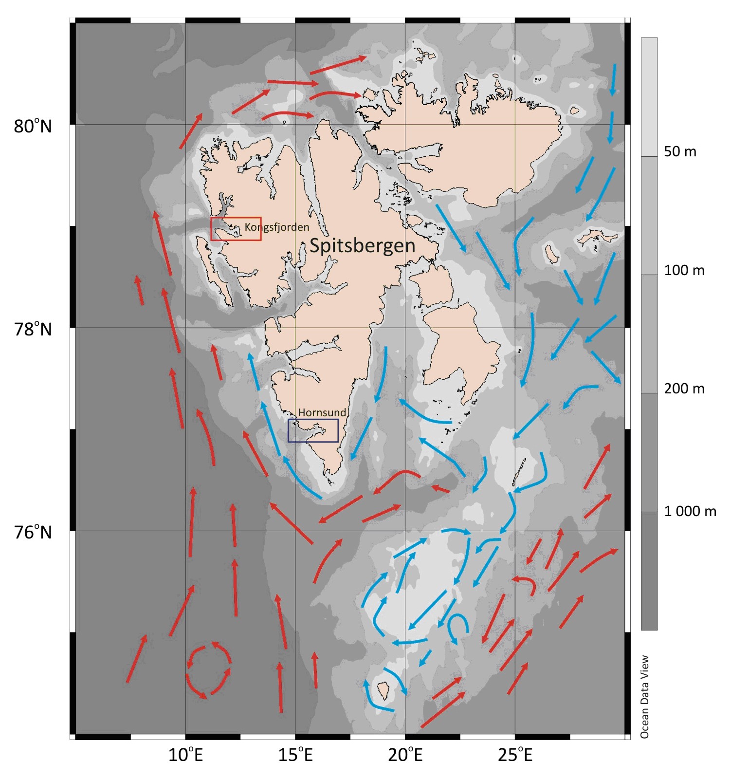
In order to verify our hypothesis, we have selected two Arctic fjords (Hornsund and Kongsfjorden) that are differently exposed to present warming. Hornsund and adjacent shelf was chosen as a “cold” site and Kongsfjorden with NW Spitsbergen shelf was selected as the “warm” area. If our hypothesis is plausible the warmer area will show the features of more mature ecosystem, when compared to the colder site. Such approach will help to understand the direction of changes observed all over the Arctic, and prepare better scenarios of the climate change consequences.. Integration of efforts and results between disciplines will be achieved by understanding the common goal and performing all the measurements in agreed places, so that physical and chemical data will supply biological observations. The archival data analysis (WP1) will give the understanding of the range of interannual variability, and will support the selection of the most representative sites for inner and outer fjord basins. Field campaign and new set of integrated, interdisciplinary measurements constitutes the second work package (WP2). Field campaign onboard r/v OCEANIA will be supplied with the set of selected measurements performed in the coastal stations. These measurements need to be done using the same methodology and in the time in two selected sites. WP3 includes research on primary production, sedimentation rates, water column stratification and respiration of selected organisms and sediments. The results of the archival and new measurements are going to feed two models ECOPATH-ENOSIM and MIKE in WP4. In WP4 we will perform simulations and comparative analyses of the collected material. Finally all data are going to be stored and made available to the broad public via internet through the Integrated Oceanographic Data Base of IO PAN (WP5). WP5 will also include data management, dissemination and socio-economic aspects of changes in the Arctic waters.
Fig. 1. Map of Spitsbergen with main seacurrents and two selected fjords
Scheme of the hypothesis testing for the four work packages:
WP number assumed scenario logic alternative WP1 long term environmental data. In 10 years time, mean summer water temperature in Hornsund is lower when compared to Kongsfjorden. Water temperature differences are statistically non important, or are valid for a single water layer only. WP2 local environmental conditions. Kongsfjorden in summer has hydrology more similar to the values observed in shelf Atlantic waters, plankton and benthos show more boreal elements and higher diversity, sediments are less rich in organic matter compared to Hornsund, while pelagic fish are more numerous. Summer season does not permit to demonstrate differences in Atlantic waters influence in both fjords, their respective biocenoses are statistically not different, sediments organic content and pelagic fish presence are alike in both sites. WP3 temperature related biogeochemical processes. Primary production starts earlier and is higher in Hornsund compared to Kongsfjorden, oxygen consumption and indvidual species is lower in Hornsund versus Kongsfjorden. Individual, secondary production is higher in Kongsfjorden. Primary production is regulated by light, not temperaturę and its values does not depend on specific fjord. Oxygen consumption is related more to the species examined than temperature. Secondary production is similar in both sites. WP4 – modelling Hydrodynamic model shows Hornsund as more isolated from the shelf waters compared to Kongsfjorden. The food web model shows immature, young unstable system in Hornsund compared to more balanced Kongsfjorden. Hydrodynamic model does not show clear differences between two fjords for they relations to shelf waters. Food web model is not discerning Hornund from Kongsfjorden.
Scheme of work packages integration.
Particular Work Packages and tasks are planned as follows:
Work Package 1. Physical drivers-
WP 1.1 Analyses of the fiords physical environment variability based on the archival hydrographic data
- The aim of this task is to investigate the hydrographic conditions in the model fjords (Kongsfjorden, Hornsund), compare this conditions to recognise the similarities and dissimilarities between both fjords and suggest the main physical processes driving the hydrographic conditions variability in both fjords.
In frames of the task, historical data from Hornsund, Kongsfjorden, adjacent fjords and shelves, collected during the r/v OCEANIA summer cruises in period 1996-2012, will be compiled and processed. The homogeneous time series obtained as the results of this work, will be used for the further analyses of the summer hydrographic conditions in the studied area. The mean properties (temperature, salinity, volume, fresh water content) of specific water masses as well as theirs variability will be calculated. The structure of the water column and horizontal pattern of the specific water mass will be analyzed.
Additionally, for the seasonal changes investigation, the time series obtained during the spring-summer, land based expedition to Hornsund in 2010 and 2011 and data from moorings (CTD, currents) working in Hornsund will be utilized.
The time series will be compared with the potential forcing: remote as the NAO or AO indexes and local as the West Spitsbergen Current temperature, intensity of the shelf-basin exchanges, air temperature, winds pattern, ice conditions. It should help to show the main processes responsible for the conditions changes in both fjords and to recognise the similarities and dissimilarities between them.
- WP 1.2 Preparation of hydrographic data for modelling and model validation
- The aim of this task is to establish the platform of communication and collaboration between the observers (physical oceanographers) and modellers groups. In frames of the task, the hydrographic data (both new and archival) will be checked, processed and prepared for the model requirements. The obtained model results (output) will be validated, using the in situ data. The snapshots and time series from model will be compared with the IO PAN results from both fjords. The mean properties of specific water masses, horizontal and vertical property distributions, time series of measured and modelled properties will be compared. This procedures will help in the model tuning.
The final model output will be analysed and interpreted.
- WP 1.3 Collection of new hydrographic data during the spring and summer campaigns
- The aim of this task is to collect the hydrographic data from fjords and adjacent shelves. The existing time series of the hydrographic data will be prolonged. But the measurements will be also planned to fill the gaps in our knowledge about the seasonal changes of the fjords environment from the spring to the autumn. Most of the data will be collected from r/v OCEANIA, during the yearly, summer cruise of this IO PAN vessel to the Nordic Seas and Spitsbergen fjords. The temperature, salinity, oxygen concentration, fluorescence, currents profiles will be performed in the deep ocean, over the shelves and in fjords. Additionally the high resolution CTD sections in fjords and shelves by means of the towed probe will be performed. Spring data will be collected during the land-based expeditions to Hornsund and Kongsfjorfden. The measurements will cover period of the beginning of the glaciers melting and bloom of the phytoplankton. The mooring measuring the temperature, salinity and current in Hornsund will be used as well.
- WP 1.4 Summer hydro-optical properties of fjords and adjacent shelf
- The aim of this task is to provide the data on the summer euphotic layer thickness, suspensions concentration, and ice cover. All data base on archival satellite photos from last 10 years. The calculation of the mean hydro-optical conditions and its variability in the examined fjords will be performed. The sea ice cover conditions in both fjords during the April-June period of the last 10 years are going to be analyzed. All data will be prepared for the modelling (task WP 4.3).
Work Package 2. Regional environmental differences- WP 2.1 Optical properties and light conditions in analysed water masses
- The aim of this task is measure light spectral features and underwater light field in particular water layers of the shelf and fjords. Concentrations of optically active elements (CDOM, suspensions) and size distribution of particles will be assessed. The relations between spectral characteristics of optical parameters and euphotic layer thickness will be established. Measurements of light scattering and absorption coefficients, radiance and underwater irradiance, CDOM and chlorophyll fluorescence will be performed. Vertical optical soundings on selected stations and horizontal tows within surface layer will be done. Laboratory spectrophotometric measurements of light absorption by CDOM and measurements of the excitation matrix and CDOM fluorescence emission are planned. Summer field campaign results will be supplied with archival data from 1996- 2011.
- WP 2.2 Identification of phytoplankton pigments suspended in a water column and surface sediments of the studied areas
- The aim of the task is to fingerprint carotenoid and phycobilin pigments that have been recognized as chemotaxonomic biomarkers of specific phytoplankton groups. Qualitative and quantitative analysis of the pigments will allow for detailed studies of phytoplankton composition. Gained knowledge will ultimately lead to a better understanding of interactions influencing Arctic food web at primary production levels. In addition, concentration of active chlorophyll species could serve greatly as a phytoplankton fresh biomass estimate in both sediments and water. In order to determine phytoplankton population by calculating specific pigments concentrations various analytical methods will be applied, including spectrophotometry, spectrofluorometry and high pressure liquid chromatography (HPLC). Report would be based on data collected during a single summer research expedition.
- WP 2.3 Chemical characteristics of water column and sediments
- The aim of this task is to compare the biogeochemical characteristics of the water column, suspended particles and bottom sediments in both fjords. This task will allow to study the organic matter sources and its fate in the water column and sediments in examined sites.
- Water chemistry – we want to define if „cold” Hornsund and „warm” Kongsfjorden are different in terms of water acidification, dissolved organic and inorganic carbon concentrations. Water samples are going to be collected with the water cast from inner and outer fjord basins, from 3 to 5 water layers of different origin (surface meltwater, Atlantic water, coastal water, etc.).
- Sedimentation – we want to define the rate of sediment accumulation and carbon burial, this task will be performed with task WP2.4 where sediment traps will be deployed on different water layers. Joined results will give full understanding of carbon fate in water column and in sediments. Three to five sediment cores (GEMINI corer) are going to be collected in each fjord, analyzed for 210Pb (for recent sediment dating) and verified with 137Cs. Carbon and nitrogen with their isotopes will be measured in sediments as well.
- Accumulation and mixing of the sediments will be assessed with the 210Pb and in selected cores with 234Th. Selection of radioactive isotopes of different half life time allows to asses the short-term and long-term sediment mixing. Expected results will be combined with the WP 2.5 task results (benthos bioturbation potential).
- Organic matter sources – the organic carbon origin will be assessed from suspension and surface sediments samples analyzed for fatty acids, carbon and nitrogen and its isotopes (δ 13C and δ 15N) as well as nutrients (phosphates, nitrates, silicates). This will allow to define the organic matter sources in two fjords. This part will be analyzed jointly with task WP 2.8 (chemical content of selected organisms). Sediment and fauna samples will be collected from the same sites. At all 50 water samples, 50 suspension samples and 150 sediment samples are planned to be analyzed.
- WP 2.4. Sedimentation
- The aim is to measure the summer values of mineral and organic sedimentation, Sediment traps (2 traps in each set at each level) will be deployed in inner and outer fjord basins below the pycnocline and 2m above the sea bed, for 2 to 6 days at each site. One liter water sample with sedimented material will be split in half, and filtered through Whatman filter papers and Milipore filters. Second half of the water from the trap will be analysed microscopically. Material will be analysed for its chemical content (chlorophyll, CHN), fecal pellets count, and sinking microplankton. Type of sediment trap and way of deployment will be the same as used in previous published studies from this area.
- WP 2.5 Zoobenthos
- The task aims to provide comprehensive assessment of taxonomic composition, patterns of distribution, species richness and diversity, taxonomic distinctness and functional complexity as well as the bioturbation potential, biomass spectra and secondary production of zoobenthos of the two fjords. Both meio- and macrofauna will be studied. The data will come from three sources: 1. archival data (both published and unpublished data collected since 1997), 2. taxonomic analysis of samples collected during previous cruises (unanalysed, stored at IO PAN), 3. materials collected within the scope of the present project. The patterns of diversity and distribution of macro- and meiofauna will be related to temporal and spatial variability in hydrological settings (link to WP 1.1. and WP 1.2), gradients in organic input (link to WP 2.2, WP 2.3) and sedimentation of glacial mineral material (link to WP 2.4). The functional complexity of benthic communities will be compared among the inner/outer basins of the two fjords. The biochemical record of trophic characteristics (isotope and lipid composition) of the dominant macroinfaunal species will be assessed and compared among the fjordic basins (link to WP 2.3 and WP 2.8). The bioturbation potential of the macrofauna will be assessed based on classification of the fauna into the bioturbation types, its biovolume and size distributions. The bioturbation potential will be used for interpretation of biological mixing record in sediments (analysed with use of 210Pb and 234Th profiles of sediment cores) with possible consequences for carbon burial in sediments (link to WP 2.3). The Benthic Biomass Size Spectra (BBSS, across macro-, meio- and microbenthic size classes) will be assessed for samples located in studied basins/fjords. All animals will be measured under a dissecting microscope using computerized image analysis system, organism dimensions will be used to calculate individual volumes and weights from published relationships. The BBSS patterns will be related to environmental drivers. The BBSS will provide data for assessment of meio- and macrobenthic secondary production and macrobenthic respiration (link to WP 3.2).The assessment of functional composition, biomass and production of zoobenthos will provide data for the ECOPATH-ENOSIM model (task WP 4.3).
- WP 2.6 Pelagic domain – micro and mesozooplankton
- The aim of this task is to recognise the similarities and dissimilarities between taxonomic composition, as well as size and trophic structure of heterotrophic plankton in relation to comparable water masses. Sampling is planned at 2-3 representative stations in each of the examined fjords. Samples will be collected from discrete water layers with Judy net – mesh size 0.056 mm, and MPS net – mesh size 0.180 mm. Standard methodology for the qualitative/quantitative analyses will be conducted with size measurements that allow biomass and size structure estimation. Trophic function and zoogeographic affiliation of the zooplankton species will be obtained from literature. Archival data from 1996-2011 will support the project single sampling campaign. Size frequency analyses, trophic functions and secondary production estimates will be used for ECOPATH-ENOSIM model (task WP 4.3).
- WP 2.7 Makrozooplankton and nekton
- This task aims at estimating fish and macrozooplankton concentrations (biomasses) and locating their distributions in both fjords during summer productive season, in order to compare the fjords in respect of large plankton and fish concentrations. Main hydroacustics methods will include: multifrequency (70/120/200 kHz) echosounder sampling for fish detection, size determination and locating their horizontal and vertical distribution; 420 kHz echosounder sampling for zooplankton biomass distribution and quantification, and chirp echosounder sampling (with frequency modulated in range of 40-90 kHz) for improving spatial resolution of the echosignal and discerning fish over the sea bottom. In order to ground-proof the remote macroplankton measurements (hydroacoustics), the Tucker Trawl with 1 mm mesh size will be used for horizontal and discrete layers hauls in high biomass concentration areas indicated by the echosounding. The results of biomass determination will feed the model ECOPATH-ENOSIM (task WP 4.3).
- WP 2.8 Food web
- The aim of this task is to assess the differences in feeding and food web structure in two compared fjords (inner and outer basins in each site). Materials for analyses will be collected during summer r/v OCEANIA cruise, with different nets, epibenthic sledges, grabs and dredges. We plan to collect key species from pelagic and benthic domains including macroalgae. Organisms collected will be identified onboard and fixed in freezer or selected for stomach content analyses. Laboratory work will cover stomachs content analyses, fatty acids and lipids analyses. The carbon and nitrogen as well as stable isotopes analyses will be performed on key species collected. Those analyses will help to identify the main prey organisms and placement of given species in the food web. Results will be combined with task WP 2.3 that is describing similar characteristics of suspensions and sediments. Data obtained will support the ECOPATH-ENOSIM model (task WP 4.3).
- WP 2.9 Population genetics
- The aim of this task is to demonstrate how the key pelagic species (Calanus finmarchicus) is diversified between populations from the open sea (WSC), NW Barents Sea and the fjords. We assume, that population from Kongsfjorden will show higher affinity to WSC population, compared to that inhabiting Hornsund (the fjord which may demonstrate higher isolation from the open sea due to stronger hydrological cross-front gradient and presence of sill). To find this we will use microsatellite markers kit on the collection of populations sampled during summer campaign in the investigated areas.
Work Package 3. Processes and environmental response- WP 3.1 Primary production
- The aim of this task is to demonstrate, how the primary production differs in two analysed areas, and how important is the shelf water advection for initiating and maintaining the phytoplankton bloom. Here the field experiments performed in April-May in coastal stations are planned, supplied with the summer cruise campaign data. Forming of spring water stratification and timing of the spring bloom, together with taxonomic differences and productivity will be assessed. Microplankton production will be assessed with the 14C method, bacterial production with tymidine. Hydrographic data, water chemistry and light measurements will supply this work.
- WP 3.2 Oxygen consumption
- The aim of this task is to demonstrate how oxygen consumption in the sediments and benthos of the two fjords is partitioned. Data will be collected during summer field work from coastal stations, supplied with measurements during summer r/v OCEANIA cruise. We will use modern oxygen sensors for the sediment oxygen uptake and respiration chambers for the individual species examination. We will assess the biological and abiotic oxygen consumption of meiofauna and selected macrofauna species, for ambient and elevated temperatures in temperature controlled chambers. Biomass and taxonomic identification will be presented for all the measurements (fresh and dry biomass for meio and macrofauna), microbial biomass by direct counting (DAPI method).
- WP 3.3 Project integration
- The aim of this task is to secure integrity and flow of information and data between project components. Regular organization of meetings and seminars, along with cross-discipline consultations. The effect of this task is the preparation of the joint interdisciplinary papers and guiding task leaders to provide answers for the key project questions.
- WP 4.1 Hydrodynamic modelling
- The aim of this task is to calculate the summer exchange rates of particulate water layers in the fjords. It will answer the question : How long water particle from given place will travel to other place in the studied area? Advanced hydrodynamic model MIKE III will be used for the demonstration of the continuity or discontinuity of particular water masses. The relation of shelf waters to the fjordic exchange will be presented for assumed hydrometeorological conditions. This task collects data from WP1 and WP2 and collates it into the integrated model of physical driving forces.
- WP 4.2 Meteorology – atmospheric drivers
- The aim of this task is to collate archival data on meteorological conditions from the studied area (coastal stations and ship-borne data) from the last 10 years. Statistical analyses of sea – land – atmosphere interrelations will be carried out. Data will supply modelling team MIKE with the atmospheric drivers.
- WP 4.3 Ecological model
- Aim of this task is to collate data on the biomass, production and trophic relations between key species in both fjords and enter them into ECOPATH - ENOSIM model – Ecopath 6 version. Model allows to analyse the complexity of food web, efficiency of energy flow and maturation of the system. Model will also show how the system may react for disturbances. Comparison of two fjords will demonstrate the key differences between the studied systems.
- WP 5.1. Indicators of goods and services provided by Arctic Ecosystem
- Ecosystem services are the benefits human obtain from marine ecosystems. These benefits can be life-supporting, create the economic opportunities, contribute to our health, sense of place, cognitive development, aesthetic or spiritual experience, personal or cultural identity. They are also an integration of ecological processes and functions. The aim of this task is to identify the key components of Arctic ecosystems that provide ecosystem services. We will also define spatial and temporal scales at which these services are delivered. We will assess how the diversity of environmental and biological data can be converted to proxies or indicators of these services. Existing databases (e.g., TEEB) and other available information will be reviewed to develop and refine the indicators of goods and services provided by the European Arctic waters. The selected indicators will then be used to investigate how these services change over time and under different warming scenarios. GAME will analyze the expected changes in ecosystem services as a result of the climate change in general and the temperature rise in particular. Dissemination activities will be planned within this task. They include the project web-page, leaflets and Arctic wikipedia. This task is desk-based, making extensive use of existing data that is readily available at IOPAN, extensive literature review and other projects focusing on the valuation of marine ecosystem services (e.g., MARBEF, VECTORS or ODEMM).
- WP 5.2 Data base and data visualisation
- The aim of this task is to design and deploy storage and enable accessibility of the data collected within project frame. As the project shall demonstrate the potential of IO PAN research team in international networks, all data are intended to be available free within one year after the project completion. Georeferenced data will be visualized in the form of GIS maps (Geographic Information System) and raw data will supply ZSPDO (Integrated Ocean Data and Information Processing System).
-
WP 1.1 Analyses of the fiords physical environment variability based on the archival hydrographic data
- METHODOLOGY
The GAME project is interdisciplinary, and each of the WPs and tasks has its own methodology briefly described in the previous section. All task leaders are experienced in their respective fields and use standard, approved internationally methodology. Our team has regular access to fully equipped oceanographic research vessel OCEANIA, with over 20 years experience in Svalbard oceanographic research. Through close cooperation with Institute of Geophysics PAN (Operator of Polish Polar Station) and Alfred Wegener Institute and Norsk Polarinstitutt (operators of research facilities in Kongsfjorden) we have access to both coastal stations. Hydrographers use modern, calibrated CTD undulated probes providing three dimentional cross sections of the entire water column. Hydroacoustics works with chirp signals and multifrequency echosounders that allows recognition of plankton and fish. Optics uses spectral radiance measuring equipment for in situ measurements and satellite imagery for archival data analyse. Chemists use standard sampling equipment onboard and up to date equipment in the laboratory (fluorometers, mass spectrophotometers, CHN analysers). Isotopic analyses (cesium and led and stable isotopes) will be done at IO PAN lab, while lipids will be analysed in external specialized laboratory. Bacterial count will be performed in specialized laboratory with the DAPI method, primary production measured with Strickland and Parsons method for separated size groups of microplankton. Benthic sediments will be sampled with multicorer for meiofauna and chemical analyses, while box corer and epibenthic sledge will be used for macro and megafauna. Respiration of the whole sediment cores and selected species will be measured in temperature regulated chambers equipped with electronic oxygen sensors. Taxonomic experience (a strong side of the IO PAN ecology team) will be used for determination of species collected in water column and sediment. Modellers will use the large MIKE III hydrodynamic numerical model (full license is being granted for IO PAN) and food web model ECOPATH_ENOSIM commonly used in recent literature. Project is based on our experience from international teams like 4th International Polar Year programs, projects AWAKE, ALKEKONGE, ATP, BANKMOD, ArcOD or networks like ARCTOS and MARBEF. Presently the scientific potential of IO PAN is large and diversified enough to undertake presented synthesis project.
-
WHAT WILL BE THE DELIVERABLES OF THE PROJECT
Deliverable 1 – Research papers in good international journals, dealing with the central hypothesis verification, and separate papers on specific project sections. Deliverable 2 - Web page presenting baseline information for scientific use e.g. international biogeographic information data base OBIS. All the data collected during the project will be openly available in one year time after the project completion Deliverable 3 – The recommendations for the monitoring of the changes in fjordic ecosystem for the international complex monitoring of marine environment – initiatives like SAON, and networks like Arctic in Transition, Arctic Net and ARCTOS Deliverable 4 – Hydrodynamic model of the two fjords, model that can be developed and expanded with new data for the research and monitoring uses
- ACIA (2005). Arctic Climate Impact Assessment. Cambridge University Press, 1042 pp
- Arnosti C., Jørgensen B.B., Sagemann J., Thamdrup B. 1998: Temperature dependence of microbial degradation of organic matter in marine sediments: Polysaccharide hydrolysis, oxygen consumption, and sulfate reduction. Mar.Ecol.Progr.Ser. 165, 59-70.
- Beszczyńska-Möller A., Węsławski J.M., Walczowski W., Zajączkowski M. 1997: Estimation of glacial meltwater discharge into Svalbard coastal water. Oceanologia 39(3), 289-297.
- Blacker R.W. 1957. Benthic animals as indicators of hydrographic conditions and climatic change in Svalbard waters. Fishery Invest.Ser. 2, 20, 1-59 pp
- Brey T. (2010). An empirical model for estimating aquatic invertebrate respiration. Methods in Ecology and Evolution 1: 92-101.
- Christensen V., Walters C.J., Pauly D. 2005. ECOPATH with ECOSIM: A user’s guide. Fisheries Centre, University of British Columbia, Vancouver, Canada, 151 pp
- Duplisea D.E. (2000). Benthic organism biomass size-spectra in the Baltic Sea in relation to the sediment environment. Limnol.Oceanogr. 45(3): 558-568.
- Eilertsen H.C., Taasen J.P., Węsławski J.M. 1989. Phytoplankton studies in the fjords of West Spitsbergen: physical environment and production in spring and summer. J.Plankt.Res. 11, 1245-1260.
- Freeland H.J., Farmer D.M., Levings C.D. (eds).1980. Fjord oceanography. NATO Conf. Ser. Plenum Press, NY Glud R.N., Rysgard S. 2007. Carbon cycling in Arctic marine ecosystems: Case Study Young Sound. Medd.om Gronland Bioscience 58, 214 pp
- Halldal P., Halldal K. 1973. Phytoplankton, chlorophyll, and submarine light conditions in Kings Bay, Spitsbergen, July 1971. Norw.J.Bot. 20, 99-108.
- Hop H., Falk-Petersen S., Svendsen H., Kwaśniewski S., Pavlov V., Pavlova O., Soreide J. 2006. Physical and biological characteristics of the pelagic system, across Fram Strait to Kongsfjorden. Progress In Oceanography. doi:10.1016/j.pocean.2006.09.007.
- Hop H., Pearson T., Hegseth E.N., Kovacs K.M., Wiencke C., Kwaśniewski S., Eiane K., Mehlum F., Gulliksen B., Włodarska-Kowalczuk M., Lydersen C., Węsławski J.M., Cochrane S., Gabrielsen G.W., Leakey R.J.G., Lonne O.J., Zajączkowski M., Falk-Petersen S., Kendall M., Wangberg S.A., Bischof K., Voronkov A.Y., Kovaltchouk N.A., Wiktor J., Poltermann M., diPrisco G., Papucci C. 2002. The marine ecosystem of Kongsfjorden, Svalbard. Polar Res. 21, 167-208.
- Hopkins C.C.E. (1981). Ecological investigations on the zooplankton community of Balsfjorden, Northern Norway: changes in zooplankton abundance and biomass in relation of phytoplankton and hydrography, March 1976 - February 1977, in: Rheinheimer G. et al. (Ed.) (1981). Lower Organisms and their Role in the Food Web: Proceedings of the 15th European Marine Biology Symposium, Kieler Meeresforschungen. Sonderheft, 5: pp. 124-139.
- Keck A., Wiktor J., Hapter R., Nilsen R. 1999. Phytoplankton assemblages related to physical gradients in an Arctic, glacier-fed fjord in summer. ICES Journal of Marine Science 56, 203-214.
- Kendall M.A., Widdicombe S., Węsławski J.M.. 2003. A multiscale study of the biodiversity of the benthic infauna of the high latitude Kongsfjord, Svalbard. Polar Biol. 26, 6, 383-388.
- Kotwicki L., Szymelfenig M., De Troch M., Zajączkowski M. 2004. Distributionof meiofauna in Kongsfjorden, Spitsbergen. Polar Biol. 27, 661-669.
- Kruss A., Tegowski J., Wiktor J., Tatarek A., 2006. Acoustic estimation of macrophytes in Hornsund Fjord (The Svalbard Archipelago). Hydroacoustics 9, 89-96.
- Kukliński P., Gulliksen B., Lønne O.J., Węslawski J.M. 2005. Composition of bryozoan assemblages related to depth in Svalbard fjords and sounds. Polar Biol. 28, 619 – 630.
- Kwaśniewski S., Hop H., Falk-Petersen S., Pedersen G. 2003. Distribution of Calanus species in Kongsfjorden, a glacial fjord in Svalbard. J.Plankt.Res. 25, 1-20.
- Lefauconnier B., Hagen J.O., Rudant J.P. 1994: Flow speed and calving rate of Kongsbreen glacier, Svalbard, using spot images. Polar Res. 13, 59-65.
- Lønne O.J., Gulliksen B. 1989: Size, age and diet of polar cod, Boreogadus saida (Lepechin 1773), in ice covered waters. Polar Biol. 9, 187-191.
- Masłowski W., Marble D., Walczowski W., Schauer U., Clement J.L., Semtner A.J. 2004. On climatological mass, heat, and salt transports through the Barents Sea and Fram Strait from a pan-Arctic coupled ice-ocean model simulation. J.Geophys.Res., Vol. 109, No. C3, C03032.
- Ørbæk J.B., Hisdal V., Svaasand L.E. 1999. Radiation climate variability in Svalbard: surface and satellite observations. Polar Res. 18(2), 127-134.
- Piechura J., Osiński R., Petelski T., Woźniak S.B. 2002. Heat and salt fluxes in the West Spitsbergen Current area in summer. Oceanologia, 44(3), 307-321.
- Sagan S., Kowalczuk P., Zajączkowski M. 1993. Optical properties of waters around Svalbard and Franz Josef Land. Proc. SPIE Vol. 2048, Underwater Light Measurements, Hans-Christian Eilertsen (Ed.), p. 64-72. Scott C.L., Kwaśniewski S., Falk-Petersen S., Millar R.M., Sargent J. R. 2000: Lipids and life strategies of Calanus finmarchicus, Calanus glacialis and Calanus hyperboreus in late autumn, Kongsfjorden, Svalbard. Mar.Biol. 23, 510-516.
- Svendsen H., Beszczyńska-Möller A., Hagen J.O., Lefauconnier B., Tverberg V., Gerland S., Ørbæk J. B., Bischof K., Papucci C., Zajączkowski M., Azzolini R., Bruland O., Wiencke C., Winther J.-G., Dallmann W. 2002: The physical environment of Kongsfjorden-Krossfjorden, an Arctic fiord system in Svalbard. Polar Res.21,133-166.
- Syvitski J.P.M., Burrell D.C., Skei J.M. 1987. Fjords. Processes and products. Springer-Verlag, New York Thamdrup B., Fleischer S. 1998: Temperature dependence of oxygen respiration, nitrogen mineralization, and nitrification in Arctic sediments. Aquat.Microb.Ecol. 15, 191-199.
- Vandieken V., Nickel M., Jørgensen B.B. 2012. Carbon mineralization in Arctic sediments northeast of Svalbard: Mn(IV) and Fe(III) reduction as most important anaerobic respiratory pathways (in press).
- Walczowski W., Piechura J., Osiński R., Wieczorek P. 2005. The West Spitsbergen Current volume and heat transport from synoptic observations in summer. Deep-Sea Res. I, 52 (8), 1374-1391.
- Węsławski J.M., Kwaśniewski S., Stempniewicz L., Błachowiak- Samolyk K. 2006. Biodiversity and energy transfer to top trophic levels in two contrasting Arctic fjords. Polish Polar Res. 27, 259- 278.
- Węsławski J.M., Legeżynska J. 1998. Glaciers caused zooplankton mortality? J.Plankt.Res. 20, 1233-1240.
- Węsławski J.M., Pedersen G., Falk-Petersen S and Poraziński K. 2000: Entrapment of macrozooplankton in an Arctic fjord basin, Kongsfjorden, Svalbard. Oceanologia, 42 (1): 57-69.
- Wiktor J., Wojciechowska K. 2005. Differences in taxonomic composition of summer phytoplankton in two fjords of West Spitsbergen, Svalbard. Polish Polar Res. 26(4), 259-268.
- Włodarska-Kowalczuk M., Pearson T.H., Kendall M.A. 2005. Benthic response to chronic natural physical disturbance by glacial sedimentation in an Arctic fiord. Marine Ecology Progress Series. 303, pp.31-41.
- Włodarska-Kowalczuk M., Węsławski J.M. 2001. Impact of climate warming on Arctic benthic biodiversity: a case study of two Arctic glacial bays. Climate Research 18, 127-132.
- Wulff F., Field J.G., Mann K.H. (eds). 1989. Network Analysis in Marine Ecosystems: Methods and Applications. Springer-Verlag, Heidelberg:15-61.
- Zajączkowski M. 2002: On the use of sediment traps in sedimentation measurements in glaciated fjords. Polish Polar Res. 23 (2), 161-174.
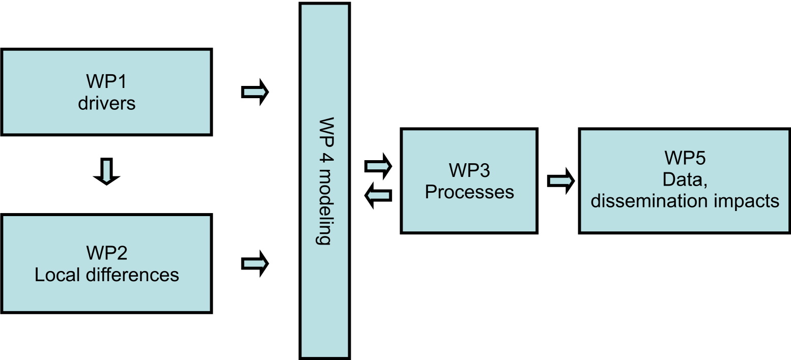
Fig. 1. Work packages organisational flowchart – WP1 provides archival data for the assessment of present day local differences between two sites (WP2), and both supply data for the modeling team (WP4), experimental works (WP3) are based on the previous work packages output and provide data for the assessment of the impact of changes and dissemination package (WP5).
Organisational flow chart – GAME
Individual budget plans
- WP11 12 13 Waldemar Walczowski
- WP14 21 Mirosław Darecki
- WP22 Alicja Kosakowska
- WP23 Agata Zaborska
- WP24 Marek Zajączkowski
- WP25 Maria Włodarska-Kowalczuk
- WP26 Sławomir Kwaśniewski
- WP27 Joanna_Szczucka
- WP28 Zofia_Legeżyńska
- WP29 Agata Weydmann
- WP31a Józef Wiktor
- WP32 Lech Kotwicki
- WP33 Jan Marcin Węsławski
- WP41 42 Jacek Piskozub
- WP43 Marta Głuchowska
- WP52 Marcin Wichorowski